3.3. Regional patterns and major sources of obsidian
Sources of tool-quality obsidian occur in discrete locations along the Western Cordillera in the south-central Andes. The spatial pattern of obsidian sources in southern Peru, spaced at an interval of approximately 100-300 km along an arc trending north-west to south-east, is evident from maps of these source distributions. It is volcanic processes at a continental scale that have resulted in emplacement of obsidian at 3000 and 5000 meters above sea level. As will be discussed in more detail in Chapter 4, obsidian sources appear to be regularly spaced paralleling the spine of the Western Cordillera, however geologists believe that "the complex tectonic and lithospheric variables at continental subduction zones preclude the development of any regular pattern of volcano spacing" (Clapperton 1993: 77-80). Nevertheless, volcanoes do occur at major crustal fractures and at fracture intersections.
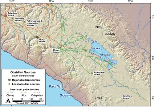
Figure 3-5. Known south-central Andean obsidian sources used in prehistory with least cost paths (Tobler's function on SRTM DEM data) from the three major sources to sites in the region.
In the prehispanic central and south-central Andes obsidian from three sources dominated the archaeological use of this material, followed by obsidian from a number of minor, local sources that were only used for tool production in the area of geological origin (Figure 3-5). Finally, there were countless sources of geological obsidian that were used negligibly, or not at all, by humans apparently due to the undesirable attributes of the glass. Outside of the study region, additional major Andean obsidian sources have been studied to the south in northern Argentina and surrounding terrain (Yacobaccio, et al. 2004;Yacobaccio, et al. 2002) and to the north in Ecuador (Burger 2003;Burger, et al. 1994).
The three most widely-circulated obsidian sources in Peru and north-west Bolivia are the Quispisisa, Alca, and Chivay types, and these three types will be investigated here in more detail. Burger et al. (2000: 348) argue that it is the large nodule size and the homogeneity of the glass that is the primary determinant of how widely obsidian was circulated in prehistory and by these criteria these three sources are exceptional in the Andes.
In the course of this research a relational GIS database has been assembled using published data on obsidian sourcing in the south-central Andes (Burger, et al. 2000;Craig 2005: 908-916;Frye, et al. 1998;Giesso 2000) and using these data a few summaries have been generated for the purposes of this study. The trends in these data show broad patterns in the use of obsidian by chemical type, but given the early stages of this kind of research, these values also reflect a sampling bias based in the history of research and the collections available for sampling. With further development of sourcing technologies, including the more widespread use of portable XRF units, obsidian from a wider variety of sites will be characterized in coming years.
|
Type |
Samples |
Sites |
Ave. Distance |
Ave. Time |
Max. Distance |
Max. Time (Hrs )** |
|
Chivay |
531 |
48 |
171.0 |
40.0 |
553.6 |
120.8 |
|
Alca |
305 |
50 |
249.6 |
66.0 |
988.7 |
260.7 |
|
Quispisisa |
525 |
63 |
260.3 |
66.7 |
846.7 |
208.5 |
Table 3-2. Three major Peruvian obsidian sources showing average and maximum distances and times. * based on straight-line distance measure, ** Least-cost path walking time based on Tobler's(1993) hiking function.
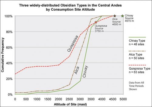
Figure 3-6. Cumulative frequency graph showing three major Peruvian obsidian sources by consumption site altitude.
As will be discussed below, the dominant pattern that has emerged for both the Chivay and the Alca obsidian types is one of highland interaction. Throughout the prehispanic period, artifacts of Chivay obsidian have never been found below an altitude of 1280 masl, and that was in the context of a Tiwanaku colony, at the site of Omo in Moquegua (Burger, et al. 2000: 338;Goldstein 1989). Alca type obsidian artifacts are similarly found mostly at high altitude; the coastal Quebrada Jaguay paleoindian finds are anomalous for Alca distributions. The next lowest altitude context for Alca is also at Middle Horizon Omo. Quispisisa, on the other hand, is commonly found at coastal sites from the Nasca area and northward, beginning with a strong representation at the cotton preceramic site of San Nicolas (Burger and Asaro 1978;Vaughn 2005).
One possible explanation for the lack of Chivay and Alca obsidian in low elevation contexts is that camelid caravans were less common in the low elevation coastal areas of southern Peru and northern Chile. While there is strong evidence of camelid corrals in northern coastal Peru (Shimada 1982), the examples of pastoral sites in the coastal areas of the south-central Andes are rare. Stanish (1992: 57) states that there no sites with corrals below 1,500 masl in the Moquegua drainage, and he presents other evidence for the scarcity of pastoral sites in southern coastal Peru. However, Wheeler et al. (1995) examine the remains of 26 camelids, both llamas and alpacas, at the Chiribaya site of El Yaral at 1000 masl in Moquegua. Moving northward in the Pacific coastal drainages, both Christina Conlee (2000) and Kevin Vaughn (2005) report evidence of domesticated camelids at low altitude in the Nasca area. Vaughn (2005: 92) describes a corral-like structure at the site of Marcaya at 1000 masl. As mentioned, the Nasca zone is rich in Quispisisa obsidian. A variety of factors may have contributed to the pattern of Quispisisa obsidian consumption on the coast and Alca and Chivay consumption in the highlands including the greater breadth of the altiplano in the Titicaca Area, the position of geological source relative to the coast, and the severe aridity in the Atacama area of southern Peru and northern Chile.
3.3.1. Obsidian and larger geographical associations
The specific cultural and temporal associations of these distributions are explored in a series of publications by Richard Burger, particularly in Burger et al. (2000). There appear to have been two overarching geographical associations that cut across the various distributions of obsidian in space and time.
Availability, demand, and mobility
Chivay was largely conveyed into the Lake Titicaca area by Titicaca Basin communities and polities that were organized around the lake and the adjacent broad altiplano. For sites in the Lake Titicaca Basin, the database shows that 453 obsidian artifacts have been sampled from all time periods, and 408 (90%) of the samples were of the Chivay obsidian type. Another interesting aspect to this pattern is that the proportion of Chivay obsidian holds true for the north Titicaca Basin as well as the south when the two areas are considered separately. Using Bandy's (2005: 92) division of the Titicaca Basin where the site of Camata and northward are considered the North Basin, and with the South Basin extending as far south as Khonkho Wankane and south-west to Qillqatani, all obsidian samples in the region were aggregated from the entire prehispanic period. The LIP site of Cutimbo, though slightly south of Camata, was joined with the North Basin sites while Incatunahuiri and the Ilave valley sites were counted with the South Basin.
|
Samples |
Sites |
Chivay Type |
Alca Type |
Other Types |
||||
|
NorthTiticaca Basin |
284 |
16 |
261 |
91.9% |
20 |
7.0% |
3 |
1.1% |
|
SouthTiticaca Basin |
231 |
13 |
205 |
88.7% |
5 |
2.2% |
21 |
9.1% |
|
Total |
515 |
29 |
466 |
90.5% |
25 |
4.9% |
24 |
4.7% |
Table 3-3. Obsidian in the north and south Titicaca Basin by counts and percents.
These patterns reveal that Chivay obsidian accounts for approximately 90% of obsidian from the Titicaca Basin, with a greater presence of Alca obsidian in the North Basin. It seems that the presence of obsidian from alternative sources, whether it was the Tumuku source (still unlocated) or other obsidian sources further to the south, counter balances the access to Alca type in the North Basin. This pattern, with heavy use of Chivay obsidian in the South Basin, reflects overall integration in the Titicaca Basin through prehistory as well as the lack of high quality obsidian sources with large nodules south of the Chivay source, until one arrives at the Zapaleri source close to the frontier of Bolivia, Argentina and Chile, located 700 km to the south of Lake Titicaca (Yacobaccio, et al. 2004: Fig. 1). It has been noted that, in cultural terms, the Chivay distributions are especially linked to areas integrated by the Tiwanaku state, the Pukara polity, and with their predecessors: the Middle Formative communities linked by Yaya-Mama stylistic features (Burger, et al. 2000). However, what is particularly compelling about the evidence from obsidian is that these social and economic links in obsidian exchange appear to predate the cultural-stylistic links and become defined in the Terminal Archaic roughly 1000 years earlier than regional evidence of the Yaya-Mama stylistic attributes that first appear at Chiripa in the southern Lake Titicaca Basin.
The distribution of Alca material is confined by the availability of Quispisisa on one side and Chivay on the other, but nevertheless Alca obsidian was transported the furthest with material during the Middle Horizon being conveyed as far as the Wari sites of Huamachuco and Marca Huamachuco near Cajamarca (Burger, et al. 2000: 336). Alca material was also transported the furthest distance at an early date, as it was conveyed 769 km to Chavín de Huantar during the Early Horizon where it was found in both elite and commoner contexts (Burger, et al. 2000: 313-314). Quispisisa predominates in Wari assemblages but it also circulated widely before the Middle Horizon, such as the 589 km to Chavín de Huantar during the Early Horizon.
Terrain adjacent to source
The altitudes of obsidian consumption sites (XFigure 3-6X) also reflect the terrain adjacent to each of the sources. The Quispisisa source is in an area with deep river valleys and a number of the sites sampled are from lower elevation or coastal contexts. The Alca source is similarly close to deep river valleys, but it also borders the altiplano and the much of the Alca samples came from the highlands of the Department of Cusco. The Chivay source is on the periphery of the broad altiplano and with no major altitude loss it was possible to transport material to a variety of sites that include Pikicallepata to the northeast and Qillqatani to the southeast. Further detail on these obsidian distributions are described below, and are published elsewhere (Burger, et al. 2000; cited in Craig 2005: 908-916;Frye, et al. 1998;Giesso 2000).

