4.1.3. High Puna: Block 2 survey and adjacent Blocks 4 and 5
This high altitude zone of the study area is dominated by the Pliocene lavas and Quaternary moraines, as will be described in more detail below in the geology section. Much of these survey blocks consisted of porous lava rock and sandy soils covered by a mantle of ash, lapilli (rock fragments between 2 - 64 mm across) and the occasional volcanic bomb (molten rock between 64 - 1000 mm). During the dry season surface water was available only sporadically across the area and, unsurprisingly, reliable water sources frequently have archaeological sites nearby. The renowned "Ventanas del Colca" tuff formations occur on the edge of the San Bartolomé survey area (block 2) at the point where the highway connecting Callalli with Arequipa climbs out of the Pulpera drainage and straightens out for its run across the open puna grassland.
This area is also remarkably wet, the environment is productive, and faunal density is relatively high. Even during the dry season the Block 2 area has reliable water.
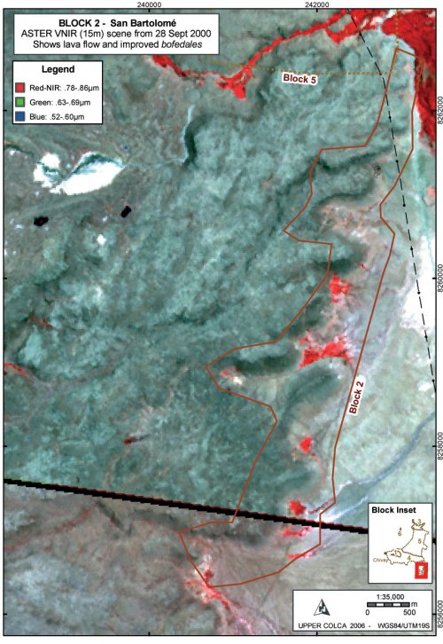
Figure 4-10. ASTER scenes with the terminus of volcanic breccia outcrop in green, photosynthesizing plant areas (bofedales) shown in red pixels, and ash in white. The black diagonal line is a seam between the two scenes.
Block 2 geography
Block 2 can be characterized as containing rich bofedales, reliable hunting opportunities, and access to lower Colca Valley resources only two-day's travel away. This area, known as San Bartolomé, can be considered a "puna rim" ecological area because animal and plant species are affected by the presence of lower elevation Colca Valley environments immediately downhill to the north and west, and warmer air rises from the lower valley affecting the local climate. The Pliocene eruption of the Barroso group vents of Huaracante, Hornillo, and Ancachita resulted in the predominantly silicic coulee flows of lava described as "Centro Huarancante" by the INGEMMET study (Palacios, et al. 1993: 139). On the eastern edge of the Huarancante Group the viscous lava flows terminate in breccia outcrops where they overlie crystalline ignimbrites (TBa-c) of older Pliocene age, also belonging to the Barroso formation. Below the toe of the lava the crystalline ignimbrites rich in dacite appear as light colored, sandy soils, where perennial surface water has created good grazing opportunities in this flat expanse to the east of the lava flows. Bofedales are found below each quebrada descending from the lava formations, a pattern that is perhaps the result of subsurface water moving through the lava flows and emerging at the contact zone with the ignimbrite formation.
A number of small rock shelters occur along the base of the upper lava flow. The rock shelters are typically dry, but the floors are sloping out onto talus slope below and so they offer little in the form of shelter inside the drip line. There are some notable exceptions, as will be reported in Chapter 7, and relatively dense occupations were found at few of the best rock shelters. On the whole, Block 2 follows along the eastern periphery of a lava flow where there is a concentration of resources. Water emerges from the lava onto the open pampa, grazing opportunities for wild and domestic herbivores on the bofedales and adjacent grasslands are good, and Andean geese and other puna bird species are seen in the greatest numbers. The lava flow provides topographic variability on the perimeter of a wide and often windy plain, providing shelter and occasional, small rock shelters.
Figure 4-11. View of San Bartolomé (Block 2) area during the dry season from atop a toe of Barroso lava looking northeastward. For scale, our white pickup truck is visible below. A rich bofedal is visible 3 km to the northeast.
Current environmental conditions suggest that the edge of the lava flow served as a rich ecotone with water, shelter, and numerous hunting opportunities for bird species, vicacha, tarucadeer, mammals, and probably the wild camelids guanacoand vicuñaat certain times in the past. We often observed a number of wildlife species in the course of research in this area including viscachaand geese, and perhaps the density of wildlife in this locale was due in part to lack of surface water elsewhere, on the adjacent lava beds and ashy soils. Even well into the dry season, parts of Block 2 area have reliable water and soft grasses.
Regional geography
Block 2 is a natural bottleneck for economic traffic moving between the Colca and the Titicaca Basin along what may be interpreted as the prehispanic trail system. Due to the steep descent to the Pulpera on the north side, and the glaciated volcano Nevado Huarancante on the south-west side, many travelers would probably have traveled through Block 2. The presence of a very large bofedal and rich hunting opportunities in the adjacent lava flows to the west probably made the Block 2 area an even greater attraction for travelers with caravan animals. This area lies on the periphery of the Colca valley and it is approximately one long day from the rich grazing areas of the Escalera access to the Colca valley, and about two days from the town of Yanque.

