4.3. Formations in the Upper Colca Valley
The volcanic terrain and the temperate lower valley in the Chivay area have largely conditioned human activity patterns in the region for the past 10,000 years. The local geological sequence will be summarized from text and maps from Palacios et al. (1993) the primary INGEMMET source for the region, as well as the ONERN (1973) geological study associated with the Majes Irrigation project, and the discussion will be supplemented with evidence from more recent specific studies in the region.
|
Figure 4-13 Rock groups in the Colca region (based on Palacios et al., 1993). |
The Colca region is dominated by late Cretaceous sedimentary rocks overlain by Tertiary flows and tuffs of basaltic to rhyolitic composition. Some Jurassic sedimentary strata are exposed consisting of sedimentary and metasedimentary rocks. The region has continued to be volcanically active during the Pleistocene and Holocene epochs in the form of stratovolcanoes that ring the Colca valley as well as exogeneous andesitic domes and flows occurring in the Colca River valley itself.
4.3.1. A geological descent of the upper Colca drainage
If one measures the river from its birthplace in Imata near the department of Puno, among a fan of tributaries that flow into Lake Jayuchaca at around 4500 masl, to its final exit into the Pacific Ocean at Camaná, the course of the Colca River is approximately 450 km (Parodi 1987: 31) with an average gradient of 1º. The river that begins in the low gradient marshlands of the Peruvian altiplano becomes increasingly steep as it descends into one of the world's deepest canyons, finally flattening out as it emerges on the littoral batholith only 48 km from the sea.
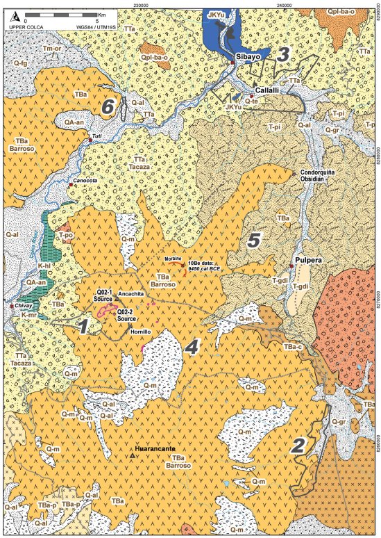
For the first 70 km from its origin the Colca River trends northwest at a low gradient, open channel descending towards the community of Huinco (3950 masl). This lower portion of this low gradient section of the Colca drainage is under the 250 million m3Condoroma reservoir, a product of the 1970s Majes Hydroengineering Project that, combined with water contributed by tunnel from the much larger Angostura reservoir in the Apurimac drainage, has resulted in a sustained year-around flow in the Colca between here and the Tuti diversion dam (Gelles 2000;Maos 1985). At Huinco, the river turns abruptly to the south-west where it continues to descend as a gentle channel, cutting through the Miocene lava formation known as Tacaza as well as wind-scoured river terraces. Immediately before entering the northern edge of Block 3 of our study area, the river cuts through strata of uplifted Cretaceous limestone striking west-north-west and forming outcrops and rock shelters on the edges of the upper river terraces (Figure 4-15). Downstream at the confluence with the Llapa River the Colca River returns again to the Tacaza formation for five more kilometers before entering the Inca formation, an andesitic exogenous dome dating to the Middle Pleistocene. This Quaternary formation fills the upper Colca valley from this point downstream to near the town of Coporaque and Yanque where fluvial conglomerates overlie it as a result of natural damming of the river by mudslides.
In its descent, 5 km below Sibayo, the incising of the Colca River begins immediately upon entering the recent exogenous dome of the Inca formation, an the river remains incised until it exits the Colca canyon approximately 100 km downstream. The Llapa River, which joins the Colca from river-left at Sibayo, emerges from the sandy tuff layers known as the Castillo de Callallituff formations (Noble, et al. 2003) and the Chalhuanca rhyolite dome fields to the south-east of Callalli. The entrenched Colca River descends more rapidly upon entering the Inca formation approximately 10 km downstream with perennial tributary streams entering primarily from glacierized stratovolcanoes that ring the Colca Valley. The first of these tributary streams are the creeks entering from the north upstream of Tuti draining the southern and eastern flanks of the Nevado Mismi volcano, while streams that form just on the other side of Mismi have recently been confirmed by a National Geographic expedition in 2000 to be the source of the Amazon. Immediately upstream of the town of Tuti a diversion dam was constructed across the Colca where the river is entrenched in a ravine 50m deep. At this point water collected by the Majes Project is diverted into a system of canals and tunnels along the south bank of the Colca that finally crosses into the fertile Pampa de Majes near the Pacific coast.
Below Tuti, the Colca river channel is deeply incised into Quaternary exogenous domes. Continuing downstream, the river turns west, again becomes entrenched, and begins dropping more steeply in the vicinity of Chivay. The geology, geomorphology and soils of the main Colca valley have been well-studied in the past several decades as a result of the "Colca Valley Terrace Project" organized by William Denevan (1986;1988;Denevan, et al. 1987) and more recent reviews of research in the main Colca valley can be found in dissertations by Wernke (2003: 34-66) and Brooks (1998: 57-84). In its steep westward drop to the Pacific littoral the river subsequently enters the 3,270m deep Colca canyon, the third deepest canyon in the world after the Yarlung Tsangpo (Tibet) and the Cotahuasi (Perú). Here the river cuts through folded sedimentary and metamorphosed layers predominantly belonging to the Yura group (Jurassic and Cretaceous) until it emerges as the Majes River on to the large alluvial plain that leads to the sea.
Cartographic sources:(Davila M. 1988;Davila M., et al. 1988;Ellison and Cruz 1985;Hawkins and Cruz 1985;Klinck and Palacios M. 1985;Palacios, et al. 1993), and 2003 field observations.
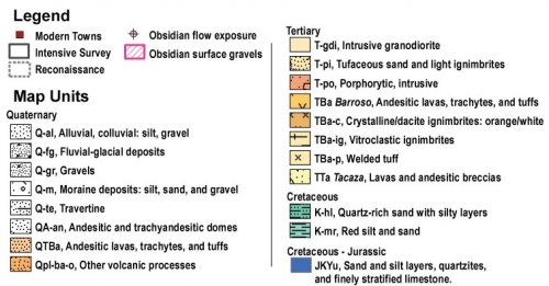
Figure 4-14. Legend showing geological map units in maps that follow.
Figure 4-15. Geological map units and 2003 Survey Block boundaries (in gray) for the Upper Colca project study area. Legend shown in preceding figure.
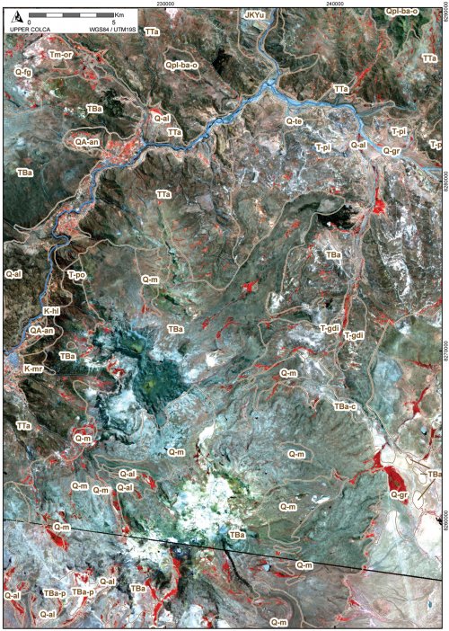
Figure 4-16. Geological map units shown on ASTER scene from 28 Sept 2000; legend is shown in Figure 4-14. In general, red pixels show areas of photosynthesizing vegetation (bofedales).
4.3.2. Yura and associated sedimentary strata
Starting with the oldest rock groups in the study region, the Yura group, the geological history of the Upper Colca region will be summarized through to the Holocene. The Jurassic and Cretaceous (> 66.4 Ma) sedimentary strata in the region include quartzite, shale to sandstone, dolomite, and limestone. The Yura sedimentary formation is exposed on both sides of the Chivay-Arequipa road around the Sumbay junction and to the 10 km to the east of the Llapa and Pulpera confluence. Quartzite outcroppings of the Yura formation appear to have provided material for the abundant artifacts made of quartzite observed in archaeological sites in the Callalli area. These quartzite Yura strata do not appear as cartographic units on the 1985 INGEMMET map (Ellison and Cruz 1985), but Parodi (1987: 47) notes that fine-grained quartzite outcrops occur west of Callalli and these features were encountered in recent fieldwork (JKYu west of Callalli on Figure 4-15 ). Quartzite outcrops form in metamorphic sandstone and occur in the oldest metamorphic strata in the Colca region. Similarly, chert, chalcedony, and quartz precipitate from diatoms in sedimentary contexts (Andrefsky 1998: 51-56;Luedtke 1994), and consequently exposures of these materials are found in the Mesozoic strata in the region and in cobbles form in many stream beds. Interestingly, cherts were noted in the Ichocollo creek in Block 6 of the survey, but an examination of the headwaters on the Cailloma (31-s) geology map (Davila M. 1988) reveals no layers older than the Tertiary in that watershed.
Steeply uplifted Cretaceous formations appear in two portions of the study area (Palacios, et al. 1993: 28-30, 36) and these formations, in addition to nodules found in riverbeds, may have provided the local sources of non-obsidian toolstone in the area. The thick calcareous Yura sedimentary exposures north of Sibayo are dramatic examples of uplift of these Cretaceous strata. Additionally, the slopes just east of Chivay below 4000m between the town of Canocota, close to Calera hot springs, and as far south as the Quebrada de los Molinos consist of Murco and Hualhuani formation sedimentary rocks that include siltstone, quartz-rich sandstone, and limestone layers. These areas, in addition to cobbles encountered in riverbeds, may have represented the local non-igneous sources of material for stone tool production that include chert and chalcedony.
4.3.3. Oligocene and Miocene lavas
Oligocene and Miocene lavasTacaza Group
Flows belonging to the Tacaza group are found throughout the south-central Andes, however the only portion that appears in the Colca region belong to the older Tacaza with dates in the range of 30.21±0.73 Ma and 26.51±0.6 Ma. At 1900m thickness these Colca lava flows are the thickest Tacaza layers in the larger region (Palacios, et al. 1993: 86).
Figure 4-17. Andesitic Tacaza deposits with breccias and tuff outcrops in the Quebrada de los Molinos drainage. The Chivay obsidian source in later Barroso deposits is found high above, on the right side of the photo.
In the Colca area, these deep deposits of lavas and breccias consist of andesites and trachybasalts (containing higher feldspar content) intercalated with tuff bands. The Tacaza layer appears predominantly on the western half of our survey zone.
Pichu Formation ash flows and the Castillo de Callalli
On the eastern side of the study area, the Tacaza formation is overlain with the Pichu formation consisting of sandy tuffs and white ignimbrites. Among these Miocene ignimbrites layers is the Castillo de Callalli formation, an ash-flow tuff that rises dramatically from Llapa river just upstream of Callalli and is a principal landmark in the Upper Colca region. In the INGEMMET study (Ellison and Cruz 1985) the Castillo de Callalli was assigned to the Pichu formation. This landmark is an approximately 400m hill of silicic ash-flow tuff ranging from densely welded to non-welded tuff. The layering in this formation has recently been subject to a more detailed study involving isotopic dating and phenocryst mineralogy (Noble, et al. 2003). The recent work shows that this formation is not a single stratigraphic unit, as presented in the INGEMMET study, but rather it consists of two layers separated by 16 Ma.
Figure 4-18. The lower section of the Castillo de Callalli is known as "Cabeza de León". Evidence of an LIP pukara was encountered on the summit [A03-935].
The lower part of Castillo de Callalli is adjacent to the main road to Callalli and follows the Llapa River. The Cueva de Quelkata, a rockshelter with a predominantly Terminal Archaic component (Chávez 1978) that was dynamited by the Majes Project road construction, is at the base of this formation. This lower section has well developed columnar jointing and is a densely welded, devitrified ash-flow tuff, and K-Ar dating on phenocrystic hornblende indicates that this lower flow is 20.7±0.6 Ma (Noble, et al. 2003: 33). The upper section is described as "partly welded vapor phase crystallized tuff with the physical characteristics of the distal part of an outflow sheet". Phenocrystic sanidine from this section yielded an40Ar-39Ar age determination of 4.72±0.02 Ma (Noble, et al. 2003: 35). The study suggests that the upper part of the Castillo de Callalli formation is associated with the Cailloma caldera to the north which erupted three times during the Pliocene. Further discussion of Miocene volcanism in the Orcopampa area of the Chila cordillera, between the Chivay and Alca obsidian sources, can be found in Swanson's (1998) geology dissertation.
4.3.4. Pliocene lavas - Barroso group
Barroso lavas in the Colca area include predominantly andesitic and trachyandesitic flows covering an area of approximately 320 km2. In the case of the Barroso group, the emplacements are contiguous lavas that occur as transversal flows, as andesitic domes, and occasionally as rhyolitic domes. At the Chivay source, two vents dating to the Barroso formation occur at Cerro Ancachita and Cerro Hornillo, and at the highest peak in the Centro Huarancante formation named Nevado Huarancante, to the south. Transversal flows and crests emanating from these flows created adjacent peaks such as Cerro Saylluta and Cerro Llallahue. Lavas, silicic coulee flows, and viscous volcanic breccias flowed from these vents and traveled up to 15km, into the Block 3 study area to the east. Curiously, in the Cailloma quadrangle study, immediately north of Chivay, Barroso group volcanism in the Cailloma caldera was dated to the Pleistocene rather than the Pliocene epoch (Davila M. 1988). The important distinction is that recent dating of Cailloma caldera deposits (Noble, et al. 2003: 35) appear to pre-date the Barroso group flows that are responsible for tool-quality obsidian formation in the western Cordillera.
At the Chivay obsidian source, Barroso group flows are superimposed on Tacaza levels, and both groups have been eroded and incised by later fluvial and glacial erosion. It is proposed by Burger et al. (1998: 205) that obsidian occurs at the Chivay obsidian source where silica rich magma from Barroso eruptions cooled rapidly when the flows contacted the older Tacaza group deposits. The emplacement of Barroso group obsidian flows will be discussed in more detail below.
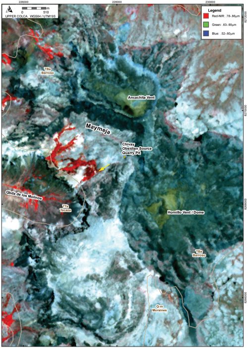
Figure 4-19. Detail of Chivay source, Maymeja area with INGEMMET geological map units shown on ASTER scene from Sept 2000. Contact between TTa and TBa on the west appears offset and likely conforms to the horseshoe shaped valley. Yellow arrow shows direction of glacial striations.Origins of the Maymeja volcanic depression
The Maymeja area is a depression surrounded by transversal flows and domes that appear to have been heavily glaciated in the Pleistocene epoch. The Maymeja depression contains certain features that resemble those of a volcanic caldera resulting from eruption-induced subsidence and collapse. However, further consultation with volcanologists indicates that the Maymeja depression is likely nota caldera. The characteristics that do suggest that Maymeja is a caldera include: a circular, steep-walled perimeter, occasional ignimbritic deposits, the Anchachita and Hornillo vents located along the margins, and remnant vent-like features in the center of the Maymeja area (Fisher and Schmincke 1984: 360;Karátson, et al. 1999;Szakács and Ort 2001). However, the small size (2 km diameter), an irregular southern and breached western margin, and overall paucity of ignimbritic materials in the region suggest, rather, that the margins of this area were defined by highly viscous rhyolitic lava flows from Ancachita and Hornillo that were subsequently eroded into the circular form of a cirque, particularly on the south-facing (heavily glaciated) slopes, as a result of abundant Pleistocene glaciation. An example of a large Pliocene caldera is the Cailloma caldera that dominates the Cailloma quadrangle immediately to the northwest of the Chivay area (Davila M. 1988). Rather, the Maymeja area can be more generally described as a volcanic depression that underwent significant glaciation during periods subsequent its Pliocene formation.
4.3.5. Pleistocene - Ampato group
Pleistocene - Ampato groupPleistocene Inca Formation
Named for the site of the Inka bridge over the Colca adjacent to Chivay, the Inca formation consists of Andesite and Trachyandesites that occur in exogenous domes and flows that appear to emanate from the north side of the Colca river, just north of the town of Chivay. These domes are composed of andesites and trachyandesites marked by a high percentages of alkali feldspars (Palacios, et al. 1993). Two Potassium Argon dates from these flows by Sandor (1992: 232-235) indicate that they formed during the Middle to Late Pleistocene (64,000 ± 14,000 bp and 172,000 ± 14,000 bp).
4.3.6. Holocene stratovolcanoes
Arequipa is a volcanically active region with a number of stratovolcanoes that have erupted repeated over the past 10,000 years. These peaks include Huayna Putina, Misti, Sabancaya, and Ubinas (Gerbe and Thouret 2004;Thouret, et al. 2002;Thouret, et al. 2002;Thouret, et al. 2001;Thouret, et al. 2005). The regular deposition of tephra from these peaks provides consistent strata that may aid in archaeological excavation work. Archaeologists working in the western cordillera will benefit from the tephrachronology sequences currently being developed by volcanologists in the region.
4.3.7. Glaciation
In modern times glaciers generally occur above 5,000 - 5,200 masl in Arequipa (Clapperton 1993;Dornbusch 1998;Fox and Bloom 1994), with differences in precipitation being the single largest contributor to variation in snowline altitude between the eastern and western cordillera. During the Last Local Glacial Maximum (LLGM) remote sensing studies of glaciated landforms suggest that there was a regional snowline depression of 600 - 800m in the western cordillera region of Arequipa during the Late Pleistocene (Clapperton 1993;Klein, et al. 1999). However glaciological studies show that the response of snowline to aridity is not uniform across the region, and that "as snowline rises in response to increasing aridity, it becomes less sensitive to temperature perturbations" (Klein, et al. 1999: 81). Recent evidence from ice and lake core studies in central and southern Peru (Smith, et al. 2005) have shown that the LLGM occurred in the tropical Andes around 21,000 cal years ago or over 10,000 years before uncontested evidence of human presence in South America.
The extent of glaciation during the Terminal Pleistocene and Early Holocene in the Colca region is of direct interest to this study of the Chivay source because the Maymeja source area itself was potentially glaciated into the Holocene epoch, and glacial geomorphology appears to have eroded high altitude obsidian deposits like Chivay. Lake and glacial core studies, as well as radiocarbon dates on vegetative material in deglaciated areas, indicate that despite the evidence for glacial advance during the Late Glacial, aka the "Younger Dryas" (9550 - 10,850 cal BCE) in the northern hemisphere, the glaciers of the tropical Andes appear to have retreated during this period (Rodbell and Seltzer 2000: 335;Seltzer, et al. 2002). The evidence suggests that the cooler temperatures were associated with a decline in precipitation, and that this precipitation decline resulted in glacial retreat.
Glaciation of the Chivay source area
These regional data on snowlines are corroborated by evidence of terminal glacial moraines in the Quebrada de los Molinos at 4400 masl and in the adjacent Quebrada Escalera at 4300 masl. On the east side of our study area glacial moraines were observed just west of the Ventanas del Colca feature on the south and east end of a dramatic U-shaped valley at 4350 masl on Quebrada Porhuayo Mayo. The INGEMMET map series (Palacios, et al. 1993) indicates that morainal deposits of silt, sand, and gravel are evident elsewhere in the study area (Figure 4-15), typically at or above 4300 masl, corroborating the evidence from the regional model with a local snowline during the LLGM at 4300 - 4400 masl, or approximately 700 meters lower than conditions evident in 2003.
A team from the University of Maine including professors Daniel Sandweiss and Harold Borns explored the question of the Early Holocene deglaciation of the Chivay Source area in the late 1990s. As shown on Figure 4-15, a10Be date of circa 10,00014C BP (9450 cal BCE) was acquired from a quartzite erratic on a moraine at 4650 masl to the east of the Chivay source area (data courtesy of Daniel Sandweiss, 2006). This sample suggests that the terrain surrounding the source was glaciated at this elevation and higher as late as the Early Holocene. Establishing the rate of deglaciation and the exposed areas at a given time period will require further glaciological study.
The evidence of glaciation in the Maymeja area of the Chivay source area is pronounced. Glacial erosion is evident on the south-facing slopes of the northern part of the Maymeja depression, as is expected in the southern hemisphere. The south and south-western slopes of Ancachita peak are steep and unstable, and at the base of this slope is a recessed glacial tarn that appears to retain water during the wet season. A moraine blocks the exit of this tarn feature, but on the slopes below lateral moraines parallel the path of the glacial tongue descending from below Ancachita. In the most deeply eroded part of this northern area contains the only continuous surface flow of obsidian encountered in the entire study area: the Q02-1 source which contained vertical, subparallel fractures and was unsuitable for tool production. Other effects of glaciation on obsidian distributions include the presence of transported obsidian nodules in parallel and terminal moraines in the Quebrada de los Molinos.
| Figure 4-20. Glacial polish and striations (aligned towards camera) on lava flows adjacent to Maymeja workshop on the southern end of the Maymeja area. |
In the southern portion of Maymeja a lateral moraine is similarly visible, and the striated and polished benches of lava dramatically attest to the extent of glaciation in the area (see yellow arrow on Figure 4-19). The direction of striation on the these lava flows is consistently south-west or dropping towards the Molinos drainage, and striations persist on high exposed benches suggesting that the glaciers were large as they were striating rocks over twenty meters above the base of the Maymeja area.
During the Middle and Late Holocene glaciers in the south-central Andes, on the whole, have retreated. Glaciological studies conducted in southern Peru and western Bolivia show that retreat is most notable during the time range from circa 10,000 to 3,000 BP (circa 9,000 - 1,000 cal BCE) (Clapperton 1993: 464-466), as well as in last decades of the twentieth century. There is evidence for small advances in glacial extent since 1000 cal BCE, most notably the Little Ice Age circa AD1500-1850. Currently Ancachita is slightly below an altitude permitting glaciation to flow downslope into the Maymeja area, though 5100 masl elevation is glaciated in drainages on peaks like Nevado Sara Sara with large glaciated expanses in the high altitude accumulation zone, and areas of peaks on the eastern side of the Andes like Carabaya (northern Puno) are currently glaciated as low as 4900 masl (Dornbusch 1998). The possible effects of this glaciation on obsidian exposure and weathering in the Chivay area will be discussed in greater detail below.


