4.3.4. Pliocene lavas - Barroso group
Barroso lavas in the Colca area include predominantly andesitic and trachyandesitic flows covering an area of approximately 320 km2. In the case of the Barroso group, the emplacements are contiguous lavas that occur as transversal flows, as andesitic domes, and occasionally as rhyolitic domes. At the Chivay source, two vents dating to the Barroso formation occur at Cerro Ancachita and Cerro Hornillo, and at the highest peak in the Centro Huarancante formation named Nevado Huarancante, to the south. Transversal flows and crests emanating from these flows created adjacent peaks such as Cerro Saylluta and Cerro Llallahue. Lavas, silicic coulee flows, and viscous volcanic breccias flowed from these vents and traveled up to 15km, into the Block 3 study area to the east. Curiously, in the Cailloma quadrangle study, immediately north of Chivay, Barroso group volcanism in the Cailloma caldera was dated to the Pleistocene rather than the Pliocene epoch (Davila M. 1988). The important distinction is that recent dating of Cailloma caldera deposits (Noble, et al. 2003: 35) appear to pre-date the Barroso group flows that are responsible for tool-quality obsidian formation in the western Cordillera.
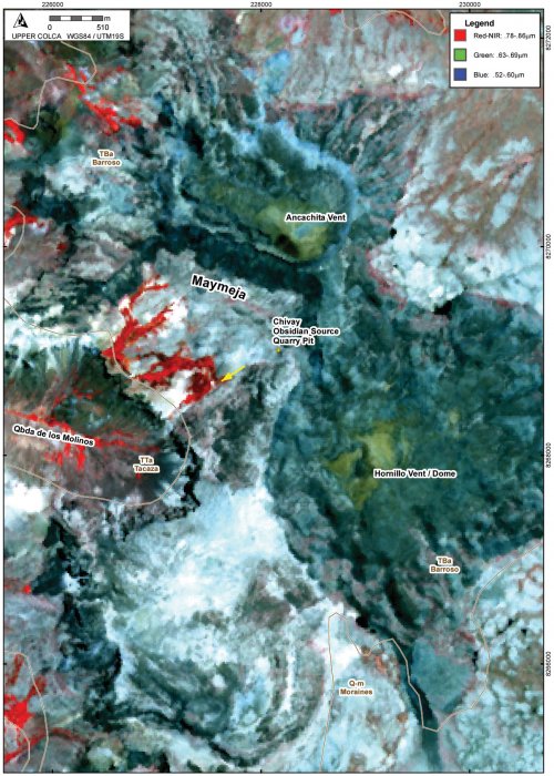
At the Chivay obsidian source, Barroso group flows are superimposed on Tacaza levels, and both groups have been eroded and incised by later fluvial and glacial erosion. It is proposed by Burger et al. (1998: 205) that obsidian occurs at the Chivay obsidian source where silica rich magma from Barroso eruptions cooled rapidly when the flows contacted the older Tacaza group deposits. The emplacement of Barroso group obsidian flows will be discussed in more detail below.
Figure 4-19. Detail of Chivay source, Maymeja area with INGEMMET geological map units shown on ASTER scene from Sept 2000. Contact between TTa and TBa on the west appears offset and likely conforms to the horseshoe shaped valley. Yellow arrow shows direction of glacial striations.Origins of the Maymeja volcanic depression
The Maymeja area is a depression surrounded by transversal flows and domes that appear to have been heavily glaciated in the Pleistocene epoch. The Maymeja depression contains certain features that resemble those of a volcanic caldera resulting from eruption-induced subsidence and collapse. However, further consultation with volcanologists indicates that the Maymeja depression is likely nota caldera. The characteristics that do suggest that Maymeja is a caldera include: a circular, steep-walled perimeter, occasional ignimbritic deposits, the Anchachita and Hornillo vents located along the margins, and remnant vent-like features in the center of the Maymeja area (Fisher and Schmincke 1984: 360;Karátson, et al. 1999;Szakács and Ort 2001). However, the small size (2 km diameter), an irregular southern and breached western margin, and overall paucity of ignimbritic materials in the region suggest, rather, that the margins of this area were defined by highly viscous rhyolitic lava flows from Ancachita and Hornillo that were subsequently eroded into the circular form of a cirque, particularly on the south-facing (heavily glaciated) slopes, as a result of abundant Pleistocene glaciation. An example of a large Pliocene caldera is the Cailloma caldera that dominates the Cailloma quadrangle immediately to the northwest of the Chivay area (Davila M. 1988). Rather, the Maymeja area can be more generally described as a volcanic depression that underwent significant glaciation during periods subsequent its Pliocene formation.
