6.3. Survey Results: Archaic Foragers Period (9000-3300BCE)
This temporal period spans the calendar years ~9,000 - 3,300 BCE and includes the preceramic periods of Early, Middle, and Late Archaic, but it specifically excludes the preceramic "Terminal Archaic" time when pastoralism began to constitute an important part of the economy. The Archaic Foragers period in the Upper Colca region refers to the time that begins with the first diagnostic artifact production in the region through to the adoption of a predominantly food-producing economy with the Terminal Archaic. This discussion will consider the first peopling of the region as well, although data from surface survey cannot address those events directly for lack of diagnostic materials. Survey results show that during this time all three survey blocks were important parts of the local economy, but the puna rim area of Block 2 appears to have presented the greatest opportunities for foragers.
In reviewing the survey results below, Archaic components encountered during survey are isolated by the following characteristics:
(1) The presence of lithic reduction debris
(2) The natural shelter potential or other locational characteristics
(3) An absence of ceramics
(4) The presence of projectile points diagnostic to an Archaic chronological period
(5) An absence of late (Series 5) projectile points
As was previously mentioned, because of the high incidence of multicomponent occupations at large sites in this volcanic region, it is relatively difficult to isolate the archaic component of larger sites.
6.3.1. Block 1 - Archaic Source and adjacent high puna
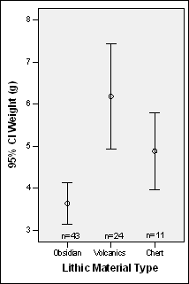
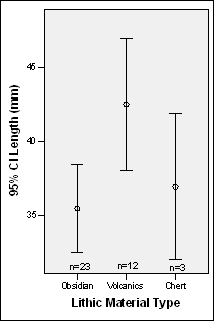
Figure 6-6. Projectile Point weights and lengths (when not broken) by material type for Block 1 and adjacent high puna areas of Blocks 4 and 5. Series 5 projectile point types excluded.
Relatively few Archaic Period projectile points were identified in the Block 1 area. The obsidian points that were found in Block 1 are, unsurprisingly, relatively large and nearly all are incompletely flaked. This is consistent with the relative paucity of obsidian points among the Series 1-4 projectile points overall where Series 1-4 obsidian points were only 25% by count of all the obsidian points as shown in Table 6-14. This pattern is even more pronounced when one considers that Series 1-4 point styles were used for over 7000 years while the Series 5 types were used for only 4800 years, or 7/10 as long. Furthermore, as was discussed above, many of these Series 1-4 obsidian points were Ob2 material which further reduces the probability that they were procured in the Block 1 Maymeja area.
The Archaic Forager sites in Block 1
In the Maymeja portion of the Chivay source all surface archaeological materials diagnostic to time periods prior to pastoralism belonged to multicomponent sites with a substantial pastoralist component. This settlement pattern reflects the exposed, windy nature of the Chivay source: all sheltered areas that may have had overnight occupation were reused. No sites that could be termed "residential bases", using the same criteria as the other blocks of the Upper Colca project survey, were identified in this area.
Projectile points dating to the Archaic Foragers period were located in course of the survey of Block 1. Unsurprisingly, these points were virtually all obsidian, and most appeared to have been broken during manufacture with longitudinal breaks and incomplete scar coverage. In addition, it appears that broken non-obsidian bases were occasionally abandoned at the obsidian source, perhaps in the process of reusing the haft with newly fashioned obsidian points. For example, the base of a chert point with evidence of pressure flaking [A03-122] was recovered on the southern slopes of the Maymeja area during the survey work.
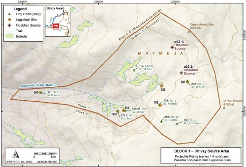
Figure 6-7. Possible Chivay obsidian source camps during Archaic Forager times.
Problems with isolating Archaic Foragers sites
One of the principal problems in isolating Archaic Foragers sites is that many of the artifactual indicators used in this research to designate sites as potentially belonging to the Early, Middle, or Late Archaic are not relevant in the obsidian source area. Of the three indicators that might potentially be used to designate sites from the Late Archaic or earlier, all three indicators have limitations.
(1) Aceramic sites.The use of ceramics in the high altitude obsidian source area appears to have been limited through the Formative Period (described in Section 6.4.1). Thus, the lack of ceramics is not evidence for a site dating to the preceramic.
(2) Material type ratios.A higher percentage of non-obsidian lithic material, primarily fine-grained volcanics, was used as an indicator of possible Archaic Foragers occupation in Block 3 of the survey area. This indicator doesn't apply to the obsidian source area, however, because virtually all flaked stone is obsidian in this area throughout prehistory.
(3) Diagnostic projectile points.Time sensitive projectile point styles continue to serve as indicators of temporal affiliation in the obsidian source area. However, as Block 1 consists of a lithic production area the projectile points found there were often incompletely flaked or broken during manufacture. As a result, a number of the projectile points did not belong to a particular point style.
The vast majority of scatters in the Maymeja area consisted of non-diagnostic scatters of obsidian with a high frequency of cortical flakes. It is possible that some of these scatters date to the period before the Terminal Archaic, and indeed many of these sites contain no ceramics. However, in this relatively high area remote from population centers, the fact that a site is a-ceramic cannot be taken as evidence that the site dates to the pre-ceramic. Given the intensification on obsidian production that occurred during the Terminal Archaic and onward, these non-diagnostic obsidian scatters are evaluated here as by-products of pastoral period intensification in the area.
Projectile Points
The human use of the Maymeja area dates to Middle Archaic (7000 - 5000 cal BCE) as is demonstrated by the presence of three transparent (one banded) obsidian projectile points of type 3b and one andesite point of type 3e depicted in Figure 6-6. The presence of 21 type 3b points in Block 2 (eight of them type 3b) indicates that the Middle Archaic occupation was predominantly a puna occupation. One of the type 3b points collected in the course of survey work was at "Molinos2" in the Quebrada de los Molinos at an elevation of only 4216 masl, suggesting that Molinos was used to travel between the lower elevation Colca Valley and the high altitude obsidian source and puna during the Middle Archaic.
Strong evidence of Early Archaic use of Chivay obsidian exists in the form of obsidian Early Archaic projectile points discussed among the data from the Block 2 and Block 3 areas of the survey, and in the early part of the Early Archaic at the site of Asana almost 200 km to the south-east. However, no Early Archaic projectile points were found in the Maymeja area of the Chivay source.
|
Figure 6-8. Middle Archaic obsidian projectile point from Maymeja area [A03-184]. |
The type 3B Middle Archaic obsidian point [A03-184] found on a moraine between two bofedales is the strongest evidence of early use of the Chivay source from the Maymeja area itself (Figure 6-8). A foliate point was identified that has one spine, pressure flaking, and it was found on a moraine at 4824 masl on the northern side of Maymeja that was perhaps glaciated during the Early Archaic. This projectile point represents the earliest date, judging from stylistic attributes, in Chivay source area. A10Be date was acquired from a quartzite sample collected from moraines at 4650 masl (Figure 4-15) that suggests that the entire Maymeja area was glaciated until circa 9000 cal BCE (Sandweiss, 2005 pers. comm.).
|
Period |
Point Type |
Obsidian |
Volcanics |
Chert |
|
Archaic |
3d |
124, 231.17 |
231.16, 780.3 |
|
|
M Arch |
2c |
110, 112 |
780.2 |
|
|
3b |
111, 184, 292, 586 |
780 |
||
|
3e |
539.25 |
|||
|
L Arch |
3f |
231.12, 537.2 |
||
|
4d |
260 |
|||
|
L2 - T Arch |
4f |
118, 266 |
Table 6-18. Diagnostic Projectile points Series 1-4 from Blocks 1, 4 and high altitude areas of Block 5, identifed by ArchID number.
Evidence from diagnostic projectile points suggest that during the Late Archaic, the use of Block 1 actually decreased because artifact counts drop from nine Middle Archaic projectile points to three Late Archaic points. Evidence from the entire survey area shows that the use of obsidian for projectile point production drops, beginning in the Late Archaic, from 65% to 52% of diagnostic projectile points. An alternative explanation for the reduced presence of diagnostic projectile points at the obsidian source is that the manufacture shifted to less advanced stages of reduction at the source such that diagnostic point styles were not recognizable in the source area.
|
Obsidian |
Volcanics |
Chert |
Column Total |
||
|
E., M., and L. Archaic (Series 1-4) |
No. |
13 (27.7%) |
4 (100%) |
1 (100%) |
18 (34.6%) |
|
mWt (g) |
11.0 (n=6) |
11.4 (n=1) |
5.0 (n=1) |
10.3 (n=8) |
|
|
sWt (g) |
6.2 |
- |
- |
5.6 |
|
|
by Sum Wt |
76 |
100 |
100 |
79.8 |
|
|
T. Archaic onwards (Series 5) |
No. |
34 (72.3%) |
- |
- |
34 (65.4%) |
|
mWt (g) |
1.74 (n=12) |
- |
- |
- |
|
|
sWt (g) |
1.1 |
- |
- |
- |
|
|
by Sum Wt |
24 |
- |
- |
20.2 |
|
Table 6-19. All Diagnostic Projectile Points from Blocks 1, 4, and Block 5 upper puna. Weights included for unbroken points only.
Comparing projectile points between the Archaic Foragers period and points belonging to the later periods demonstrates that, while counts are low for Series 1-4 points, the mean weight of projectile points (11g) is 6.3x larger than the mean weight of Series 5 projectile points. It should be noted that variability in Series 1-4 points is also much higher, with a standard deviation of more than one-half of the mean weight. This is consistent with size differences in the point types as described by Klink and Aldenderfer (2005) but it underscores the different quantities of material invested in point production at the obsidian source.
Site Type: Logistical Camps
Based primarily on the distribution of diagnostic projectile points and associated environmental data in the Maymeja area, it appears that "logistical camps" are prevalent in the settlement organization of the Chivay source area during the Archaic. Foragers likely visited the Maymeja area as an embedded strategy, combining obsidian procurement with hunting as the high relief area and talus boulders shelter a relative abundance of wildlife. Today, hunters visit the area to shoot viscacha, and a small population of vicuñaare occasionally seen in the area.
Site size estimates for logistical camps were not included in this portion of the study because all of these sites are multicomponent and, in most cases, obsidian scatter sizes more accurately reflect later periods with greater intensification of production.
|
Logistical |
Logistical Campss |
All Data |
All Data |
All data in B1m - Archaic Sitesm |
|
|
No. |
6 |
137 |
|||
|
Altitude (masl) |
4723.8 |
286 |
4806.8 |
215.1 |
-83 |
|
Slope (degrees) |
13.15 |
3.3 |
11.5 |
5.9 |
+1.65 |
|
Aspect (degrees) |
NW (83%) |
NW (45%), W (18%), SW (16%) |
|||
|
Visibility/Exposure |
8.5 |
7.1 |
15.1 |
11.9 |
-6.6 |
|
Dist. to Bofedal (m) |
257.7 |
223 |
219.7 |
275.3 |
+38 |
Table 6-20. Environmental characteristics of potentially Archaic Foragers logistical camps in Block 1.
The sites identified as possible Archaic Foragers logistical camps in this study are, on average, lower in elevation because the sample is small and one site in the low portion of Quebrada de los Molinos pulls down the average elevation. The sites are on slightly steeper slopes and they are predominantly on slopes with a northwest aspect at roughly twice the rate of the entire dataset of archaeological features in Block 1. The pattern of settlement location that prioritizes steeper slopes with a northwest aspect would ensure the maximum of afternoon sun and therefore higher temperatures. The viewshed analysis indicates that these locations are slightly lower visibility and exposure than is typical in the Block, although the standard deviation on these measures is quite high. Finally, the logistical camps are slightly further from bofedales than is typical in the Block 1.
The land-use patterns of these six potential logistical camps in the obsidian source area are consistent with models of forager behavior (Kelly 1992). In these models, access to water is not a top priority, as short stays at dry camps are common. Expedient shelters were probably used at these obsidian source logistical camps due to relatively high mobility and short stays. According to this locational model, places with higher ambient temperature would have been a top priority for logistical camps because of the generally cold environment and the limited built shelter offered in logistical camp construction. These settlements contrast with the later pastoralist settlement pattern that prioritizes access to pasture and water for the herd. It is sometimes difficult to differentiate small forager logistical camps from the common small pastoralist camps that were encountered on the tops of moraines and other exposed locations that have commanding views of bofedales where the herd was presumably grazing through much of the day.
However, as is apparent in Figure 6-7, only one pre-pastoralist projectile point style [A03-184] was identified on these exposed moraine sites in the center of the Maymeja zone, and this point was located relatively close to the obsidian exposures at 4900 masl. The point was found at an area later used by pastoralists (with good views of bofedales to the north and south), the site had no other features consistent with forager logistical sites in the area, and therefore it was not interpreted as such.
A03-580 "Molinos 2" [A03-580 - A03-586]
The lowest elevation site in Block 1 is "Molinos 2" [A03-580], at 4216 masl. It is located below a large breccia boulder that came to rest on a terrace on the south bank of Quebrada de los Molinos. The site is located along the principal trail that climbs up Molinos from the town of Chivay. The north side of the boulder serves as a small rock shelter with the following dimensions: width 5.5m, depth 2.1m, height 0.8m. The site has been bisected by a stream that has become heavily incised from torrential runoff events, perhaps most recently from the El Niño - Southern Oscillation of 1997-1998. The effect of this runoff on the archaeological site is twofold. First, the rock shelter has been filled in with debris, as is visible in Figure 6-9a, and the overall dimensions of the rock shelter have been greatly reduced as it was probably higher and perhaps deeper prior to the infilling. Second, the downcutting of the stream has revealed hundreds of flakes of obsidian and chert in profile in the terrace below (Figure 6-9b).
Figure 6-9. (a) Small rock shelter at "Molinos 2" [A03-580] is filled with debris from heavy runoff. (b) A density of flakes, predominantly of obsidian, are found in profile in the flood channel.
This site appears to have represented a regular travel stop between the obsidian source and the main Colca valley below. Projectile point evidence from the Early and Middle Archaic are relatively scarce elsewhere in the lower elevation portions of the survey, although 7% of the projectile points recovered during the Block 3 (Callalli) survey were characterized as Early and Middle Archaic. Steven Wernke's (2003: 541-542) survey in the main Colca valley found evidence of Early and Middle Archaic occupation at twelve sites in the form of diagnostic projectile points, and only one site (YA66) was below an altitude of 4000 masl.
A03-536 "Mamacocha 3" and A03-556 "Mamacocha 5"
These two sites share the characteristics of being located on lateral moraines that parallel the east-west direction of the Molinos drainage. Lithic scatters associated with large blocks of tuff that serve as small rock shelters are the principal features of these sites. A broken (longitudinally snapped) Middle Archaic 3e projectile point [A03-539.25] was found in one of these moraine sites; interestingly this point was made of andesite and was the only non-obsidian artifact found in this cluster of sites. A Late Archaic 3f obsidian point was also found in this area. Corral features and ceramics were identified here as well, indicating that the sites are multicomponent.
Figure 6-10. Lithic scatters are associated with shelter provided by large boulders located along moraines [A03-539]. One surveyor that is visible in blue provides scale.
The occupation of these sites was likely related to the use of resources in the upper Quebrada de los Molinos valley, although the moraines are not an obvious place for site locations. The sloping moraines are far from level and there is little open space between boulder, however the sites are probably located on these moraines due to factors that include insolation on these north-west trending moraines, the availability of water descending from Maymeja and the flanks of Hornillo, and the shelter offered by the large boulders.
A03-291 "Hornillo 9"
This high altitude site consists of an obsidian scatter that parallels a lava flow that trends northwest-southeast. The scatter is located in the sheltered area below the flow on ashy soil and while water is not presently available in this area, the site is level, it is relatively sheltered, and insolation is high.
Figure 6-11. Obsidian scatters were found on benches along the base of these viscous lava flows at 5040 masl [A03-291].
This site, and a neighboring site 70m downslope [A03-295] consist of obsidian scatters in areas sheltered by lava flows and the sites are adjacent to the lowest cost route out of the Maymeja area. The "Camino Hornillo" road [A03-268], described elsewhere, passes only 60m south-east of this area but, interestingly, no diagnostic artifacts were found that might connect these sites with the road. The only diagnostic artifact found at this site is A03-292, a possible 3b Middle Archaic projectile point with incomplete scar coverage made of clear Ob1 obsidian. At 5040 masl this projectile point represents the highest altitude diagnostic artifact found in the course of the survey. In some ways it is unsurprising that the only diagnostic point found at this site is from a time that predates camelid domestication: the camp offers no water or grazing and it would make little sense for herders to camp in this location when ample water and grazing opportunities lie on either end of Camino Hornillo.
A03-163 "Maymeja 4"
As shown in Figure 6-7, several diagnostic projectile points were found to the south-west of Maymeja. This access to the Maymeja area follows a trail that descends the lava flows from the western plateau of Cerro Hornillo. This trail is one of the most direct routes between the heavily traveled Escalera corridor to the south (in the Block 4 survey zone) and Maymeja. Just below the rim of the western plateau an obsidian scatter was found, along with one obsidian 3d projectile point [A03-124]; 3d is a style that is only diagnostic to the Archaic Period, generally.
At A03-255, another site approximately 500m to the south and on the broad rim of the Cerro Hornillo western plateau, another diagnostic obsidian projectile [A03-260] was found along with a number of ceramics. This area was a minor egress to the Maymeja area and perhaps was used by groups that were primarily interested in exploiting the bofedal in the lower part of Maymeja, and then crossing over to the Escalera area. It is also worth noting that the Camino Hornillo road [a03-268], along with a 4f Terminal Archaic projectile point [a03-266] were found just 500m east of here, but these features are interpreted as belonging to the Early Agropastoralist period described later.
Blocks 4 and 5 Reconnaissance Areas
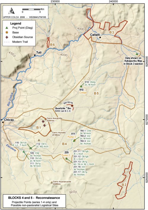
The expansive Block 4 and 5 areas were evaluated opportunistically rather than systematically in the course of the 2003 fieldwork; and these blocks were examined to a limited extent during preliminary research in 2002. The targeted nature of this work in these blocks precludes any systematic evaluation of site distributions and settlement patterns because of biased survey coverage, however hiking across these reconnaissance areas provides a measure of the variety in each block. Data from the survey of these reconnaissance blocks provide insight into the access that these zones offer to the Chivay source, as well as the initial obsidian production activities that occurred there.
Figure6-12. Map of project area showing Reconnaissance Blocks 4 and 5 with diagnostic projectile points and logistical sites from the Archaic Foragers period.
As with the settlement pattern in other lava rock areas of in the study zone, the arid and patchy environment of these blocks resulted in a relatively high rate of site reoccupation. The prevailing occupation pattern for the Archaic in Blocks 4 and 5 appear to consist of a few relatively large camps that are typically less than a few hundred meters from water, and often close to some kind of topographic prominence that offers both shelter and a view of the surrounding terrain. Isolated finds are also relatively frequent as should be expected of distributed subsistence, based on foraging.
The evidence points to an Early Holocene deglaciation of the Chivay Source area. A10Be date acquired from a quartzite erratic on a moraine to the east of the Chivay source area (data courtesy of Daniel Sandweiss, 2006), suggests that the terrain surrounding the source was glaciated at the 4650 masl level and higher as late as the Early Holocene (Figure 6-12and Figure 4-15). Establishing the rate of deglaciation for the different areas that may have been exposed in a given time period will require further glaciological study.
A03-229 "Puma 2" [A03-229 - A03-232]
This rock shelter, and the slopewash below it, is one of the more effective shelters occupied during the Archaic in this area. The shelter is above an active corral and immediately south of a medium sized estancia owned by the Puma family. At this rock shelter, a longer incidence of occupation is suggested by a higher density of lithics. The rock shelter itself is something of a tunnel with two entrances as a result of a collapse in the center portion of the shelter. Both entrances have had walls constructed across them, and the northern of the two walled entrances is visible in Figure 6-13.
Figure 6-13. Rock shelter [A03-229] passes behind the collapsed margin of the grey lava flow in the center of the photo. Walls are built to partially close off both of the two entrances.
This shelter faces the morning sun and perennial water is available in a stream approximately 300m east. Unfortunately the construction of a large corral, on a relatively steep (10°) slope (the upper wall of which is visible in Figure 6-13), has resulted in a great deal of disturbance for artifacts just below this shelter. The many projectile points identified here were found among the stirred-up debris at lower end of this sloping corral.
|
Ob1 |
Ob2 |
Volcanics |
Chert |
Total |
|
|
Biface |
1 |
1 |
|||
|
Biface Broken |
2 |
3 |
5 |
||
|
Flake Broken |
8 |
8 |
|||
|
Flake Complete |
1 |
1 |
2 |
||
|
Flake Retouched |
1 |
1 |
|||
|
Flake Retouched Broken |
1 |
1 |
2 |
||
|
Proj Point |
1 (3d) |
1 |
|||
|
Proj Point Broken |
5 (3f,3d,unk) |
1 (unk) |
6 |
||
|
Total |
9 |
5 |
1 |
11 |
26 |
Table6-21. Lithic artifacts from site A03-229 excluding eleven Series 5 projectile points.
This site contained a substantial number of points that are possibly Late Archaic, although the site also contained eleven Series 5 Term Archaic - Late Horizon points made from homogeneous Ob1 obsidian (that accounted for 60% of all projectile points by weight), but these were excluded from Table 6-1 because they are not Archaic. Based on the condition of the partially worked artifacts, much of this surface assemblage appears to have been abandoned during middle stage reduction in point production. One of the points was fine-grained volcanic, and had incomplete scar coverage. Of the obsidian artifacts, 45% of the projectile points and other bifacially flaked implements had incomplete scar coverage, and 66% were broken. These data suggest that this area, within a day's travel of the obsidian source, represented an intermediate stage in the lithic reduction trajectory as one departs the source. Interestingly, only 16% of the obsidian artifacts contained heterogeneities (Ob2) and these implements were nearly all classified as bifaces rather than as points. Ob2 obsidian was observed occurring as surface gravels only 4 km from this site, and the Maymeja source of Ob1 obsidian is nearly double that distance as the condor flies. Although this may be a signal from the later pastoral period, when shearing and other expedient uses for obsidian expanded, there appears to have been an emphasis on the use of Ob1 obsidian for point production while Ob2 obsidian was used for other bifacial tools.
Unfortunately, due to the disturbed state of the slope from the corral, and the artifact breakage that can result from animal trampling, further analyses of these data does not appear to be worthwhile. Future test excavations in the rock shelter may offer more insights into activities in this intermediate zone.
A03-777 "Puma 3" [A03-777 - A03-780]
As with the Puma 2 [A03-229] site higher in the valley, this site consists of a small shelter on the edge of a lava flow with improvements through the construction of rock walls.
|
Ob1 |
Ob2 |
Volcanics |
Chert |
Total |
|
|
Biface |
1 |
1 |
|||
|
Core |
4 |
4 |
|||
|
Flake Broken |
2 |
1 |
3 |
||
|
Flake Complete |
1 |
7 |
1 |
9 |
|
|
Flake Retouched |
1 |
1 |
|||
|
Heat-shatter |
1 |
1 |
|||
|
Proj Point |
1 (3b) |
1 |
|||
|
Proj Point Broken |
2 (2c,3d) |
3 |
|||
|
Total |
3 |
13 |
2 |
5 |
23 |
Table 6-22. Lithic artifacts from site A03-777 excluding 1 Series 5 projectile point.
Two patterns emerge from the lithic materials encountered at this site. First, the Pastoral period signature is weak as there is only one Series 5 point (and it was completely flaked, Ob1 material). The Archaic Foragers points are all Middle Archaic and they were made of volcanics and chert, not obsidian. A second notable pattern about these lithics is that it appears that there was reduction of primarily Ob2 obsidian at the site based on cores left at the site. These cores were not exhausted, one weighed 47 g and measured 4.5 x 4.1 cm. This is consistent with the evaluations of Ob2 obsidian more generally, in that it is used because it is widely available, yet there appears to have been a preference for Ob1 material and, in particular, for projectile point manufacture. This site is only 3 km from the exposures of surface gravels of Ob2 obsidian on the south-east flanks of Hornillo, but over 6 km from the Maymeja zone with the Ob1 material.
A03-910 "Collpa" [A03-910 - A03-925]
Collpa [A03-910] is approximately 9 km from the Maymeja area of the Chivay source, and it is also 8 km from Callalli to the north, therefore it is roughly equidistant between Block 1 and Block 3 survey areas. Collpa is an important site in this study because due to its position between the two survey blocks, it provides an opportunity to observe lithic consumption patterns midway between the obsidian source and the B3-Callalli zone. In fact, both the modern owner of Maymeja and his hired herder are from Callalli and this site of Collpa lies directly along their path from Callalli to Maymeja.
This site is located among a cluster of unusual-looking tuff outcrops that occur at the western extension of the Pichu formation to the south of Callalli (Ellison and Cruz 1985). This cartographic unit is described by the INGEMMET study as crystalline tuffs and ignimbrites. These outcrops are potentially in the same formation as the tuffs described and dated recently by Noble et al. (2003) as the ash flow sheets belonging to the "Upper Part" of the Castillo de Callalli section, a formation that was described above (Section 4.3.2). If so, then these tuff outcrops date to the Early Pliocene and are probably associated with volcanic activity at the Cailloma caldera to the north of the Colca valley.
Figure 6-14. Multicomponent site of A03-910 "Collpa" among crystalline tuff outcrops. Two dark figures are visible, standing apart in the right and center-right half of the photo, providing scale.
The site of Collpa [A03-910] contains predominantly Series 5 projectile points and is potentially, then, a pastoralist occupation however several projectile points dating to the Archaic Foragers were also found here. The reduction strategies applied in this area are summarized below, although it is difficult to establish if these data on reduction activities at Collpa reflect the Archaic Foragers time or to the later pastoralist period.
The site contains several small rock shelters but the principal lithic scatter is located on a high point in the grassy center of the Collpa area. The site has distinctive concentrations of obsidian and high intrasite variability, however the temporally diagnostic artifacts are not patterned such that one can differentiate components in these scatters. Thus, the site will be considered in one group here.
|
Ob1 |
Ob2 |
Volcanics |
Chert |
Quartzite |
Total |
|
|
Biface |
4 |
6 |
1 |
11 |
||
|
Core |
11 |
5 |
4 |
20 |
||
|
Flake |
98 |
32 |
8 |
29 |
2 |
167 |
|
Retouched Flake |
18 |
7 |
5 |
30 |
||
|
Hammerstone |
1 |
1 |
||||
|
Heat-shatter |
1 |
2 |
3 |
|||
|
Perforator Broken |
1 |
1 |
||||
|
Projectile Point |
6 (2c,unk) |
1 |
7 |
|||
|
Kombewa Flakes |
5 |
1 |
1 |
7 |
||
|
Bifacial Thinning |
8 |
1 |
1 |
10 |
||
|
Total |
190 |
10 |
42 |
2 |
244 |
Table 6-23. Lithic artifacts from site A03-910 excluding five Series 5 Ob1 projectile points.
The site contained a relatively high frequency of Kombewa flakes (also known as Janus flakes), a flake with bulbs of percussion on both ventral and dorsal surfaces that appears to have served as blanks for a Series 5 projectile point production. This is an artifact type that will be discussed in more detail in the discussion of the Q02-2u3 test unit at the Maymeja workshop in Chapter 7. Collpa contained a relatively high frequency of bifacial thinning flakes (n = 10) as per the calculated BTF index.
The material types in use at Collpa are consistent with the geographical position of this site as it lies half-way between the Maymeja zone of the Chivay source and Callalli. The Maymeja zone contains Ob1 obsidian, the eastern flanks of Hornillo contain Ob2 obsidian, and the area of Callalli in Block 3 contains abundant use of quartzite and chert that had often been heat treated. At Collpa [A03-910] a number of cores of both Ob1 and Ob2 chert were recovered.
|
No. |
mLength |
sLength |
mWeight |
sWeight |
|
|
Ob1 |
10 |
39.33 |
7.82 |
25.46 |
19.41 |
|
Ob2 |
5 |
34.26 |
13.67 |
15.98 |
19.72 |
|
Chert |
4 |
36.55 |
2.18 |
19.55 |
7.60 |
Table 6-24. Complete Cores at Collpa [A03-910].
Reduction in the Collpa site shows that there was provisioning occurring from both Maymeja and the eastern flanks of Hornillo where Ob2 obsidian is found, as well as chert being used that perhaps came from the Callalli area where chert is abundant. Ob1 cores are clearly dominant at this site. Ob1 is more common, larger, and heavier despite the greater distance to the Maymeja area where this study shows that Ob1 obsidian is found. It is difficult to establish the antiquity of the Callalli ownership of Maymeja, but if movement between Callalli and Maymeja is a pattern that has a long history, then perhaps the greater presence of Ob1 obsidian reflects this larger mobility pattern.
A03-109 through A03-118 "Escalera" Area
A number of Middle Archaic points, as well as other Archaic points, were identified along the major travel route climbing up from the Chivay area of the Colca valley to the puna; hence the name "Quebrada Escalera". This was a route out of the Colca valley that was widely used until the 1940s when alternative roads were improved. These projectile points are essentially isolates although the A03-109, 110, 111 projectile points were found in a small cache adjacent to a large corral - possibly due to salvaging and aggregation by the pastoralists that use the large corral.
Figure 6-15. Photo of moraines and bofedales of Escalera south-west of Chivay source.
The region of Escalera contains extensive moraines interspersed with large bofedales due to the runoff from the glaciers of Nevado Huarancante. A major thoroughfare that bypasses the Chivay source to the south climbs through this valley following the moraines. This area contains varied habitat that probably offered relatively rich hunting throughout Archaic, as well as serving as a transition zone between valley and puna ecological zones.
Discussion
Distributions of diagnostic projectile points present the strongest surface evidence of Early, Middle, and Late Archaic activities at the Chivay source, and therefore inference about this period is strongly influenced by the production and discard of Series 1-4 point types in prehistory. Many of the obsidian projectiles found in the Block 1 survey and the Block 4 and 5 reconnaissance area had incomplete scar coverage, which is consistent with the reduction pattern one would expect near the source. The preferential use of Ob1 over Ob2 obsidian is evident from the core discard and the tendency to use Ob1 for projectile point production. The presence of Chivay obsidian at consumption sites, both locally and regionally, during the Early Archaic suggest that the source area was accessible during this time, there is no evidence of the use of the Maymeja area until the Middle Archaic.
6.3.2. Block 2 - Archaic San Bartolomé
The Block 2 survey area parallels the edge of the Huarancante lava flow where geological features include the contact between the toe of a Pliocene lava flow and the open pampa. The pampa consists of ignimbrites weathering into a sandy soil and surface water in this area creates grassland with bofedales. Considering the study area on the whole, the greatest intensity of occupation during the pre-pastoralist Archaic appears to have taken place at San Bartolomé (Block 2). Sites in the area were surface collected in previous years by students from field classes at the Catholic University of Santa Maria in Arequipa (José-Antonio Chávez Chávez, Sept 2002, pers. comm.), but nevertheless a high density of projectile points was found in this area.
The evidence for long duration and diversity of activities comes primarily from the spatial distributions of projectile points and their material types. The San Bartolomé area was also an important zone during the subsequent pastoralist periods, due in large part to the rich bofedales mentioned above, that make differentiating pastoralist from Archaic Foragers (Early, Middle, and Late Archaic) occupations difficult. For foragers during the Archaic Period the area contains a rich mixture of reliable hunting opportunities and access to lower elevation vegetative resources in the Colca valley, two days travel away.
Projectile point distributions
Block 2 contained an abundance of projectile points diagnostic to the Archaic Foragers period. The wide variety of point types probably reflects the mobile strategies of Archaic foragers and the variable geology of the larger region.
|
Period |
Point Type |
Obsidian |
Volcanics |
Chalcedony |
Chert |
Quartzite |
|
Archaic |
3d |
489 |
449, 1019 |
394 |
||
|
E Arch |
1a |
355, 379, 380, 941, 1015, 1037, 1044.2 |
384 |
384 |
||
|
1b |
398, 411, 493, 522, 945, 956.3, 1026.3 |
444,514, 956.2 |
469, 1034 |
|||
|
E-M Arch |
2a |
512, 949 |
||||
|
L Arch |
3f |
490 |
390, 480 |
|||
|
4d |
960, 963, 964, 1017, 1018, 1024.4, 1024.5, 1048, 1067 |
|||||
|
Late Arch - T Arch |
4f |
407, 450, 463, 818, 943, 954, 1031 |
364, 1057 |
486 |
||
|
M Arch |
2c |
517, 873, 953, 1016, 1023, 1035, 1036, 1044, 1062 |
822, 1021 |
|||
|
3b |
386, 820, 944 |
958, 1051 |
509, 942 |
951 |
||
|
3e |
519 |
395 |
||||
|
MH |
4e |
472 |
Table 6-25. Diagnostic Projectile points Series 1-4 from Block 2 identifed by ArchID number.
Obsidian projectile points are extremely well represented in this area, but fine-grained volcanic material, primarily andesite, is also relatively abundant among the projectile point types except the Series 5 points. Chert and chalcedony points were present in Block 2, as well as chert knapping debris in low densities throughout the area, suggesting that chert nodules are available in relative proximity as well.
Figure 6-16. Projectile Point weights and lengths (when complete) by material type for Block 2. Series 5 points are excluded, chalcedony is included with chert, and quartzite is described separately.
Obsidian is well represented by count, but obsidian is typically smaller regardless of material type, even if the small, triangular Series 5 point types are excluded. An analysis of variance of material type showed that these differences between mean weights was extremely significant (F = 11.511, p> 05). Remarkably, even in this region, which is a day's travel from the Chivay source, obsidian appears to be used in the smaller size range of projectile points of the larger types.
Comparing the counts for weights and lengths in Figure 6-16 reveals that approximately one-half of the projectile points made from both obsidian and fine-grained volcanic materials are longitudinally snapped (and therefore no length measurement was taken). Thus, this difference in weights between obsidian and volcanics does not reflect differential breakage by obsidian points as it appears that the mean lengths of non-broken obsidian points are also roughly 8cm shorter than the mean lengths of fine-grained volcanic points. Other possible explanations for the smaller obsidian projectile points include the in-haft resharpening and other forms of recycling that would result in smaller sized obsidian points in the styles of larger types. The was evidence of resharpening noted on some projectile points, but a restudy would be required to examine resharpening evidence consistently in the collection.
Block 2 Archaic Foragers Settlement Pattern
Archaic Forager sites in the Block 2 portion of the survey fall into two major categories as indicated by the surface materials. One category of site consists of large sites that are sheltered in at least one sector of the site, and the other type of site appear as more diffuse scatters along the edge of the grassy plain that are largely intermingled with the pastoralist settlement pattern. These two kinds of sites will be discussed below, along with the characteristics of the artifacts found in each type of site.
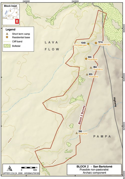
Figure 6-17. Archaic Forager sites in Block 2: Major sites described in the text.
Site Type: Residential Base
Archaic Forager period sites take two principal forms in this survey block. Residential bases, with what appears to be a great deal of redundancy of occupation, were encountered in a few locations with distinctive attributes (like shelter from wind). Projectile points styles diagnostic to Archaic Foragers time periods are encountered in a variety of contexts that include some areas near bofedales that were later intensely utilized by pastoralists, and some areas that show more spatially distributed occupational histories.
A03-1014 "Chiripascapa" [A03-1014 - A03-1057]
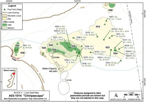
Chiripascapa was recorded as three sites due to variability in the artifact distributions and the differences in topography. Due to downslope movement in the steep talus zone in one portion of the site, and deflation in the lower site complex, the Archaic Foragers component of this site complex will be described as one group.
|
ArchID |
SiteID |
FileType |
Description |
Area (m2) |
|
1014 |
1014 |
Site_a |
"Chiripascapa" |
24,550,334 |
|
1023 |
1014 |
Lithic_a |
Medium Dens, 100 Obs |
38,785 |
|
1024 |
1014 |
Lithic_a |
Medium Dens, 89 Obs |
124,943 |
|
1025 |
1025 |
Site_a |
"Chiripascapa2" |
27,927,630 |
|
1026 |
1025 |
Lithic_a |
High Dens, 100 Obs |
2,470,331 |
|
1038 |
1025 |
Lithic_a |
High Dens, 30 Obs |
1,086,213 |
|
1041 |
1025 |
Ceram_a |
Painted LIP |
186 |
|
1043 |
1025 |
Lithic_a |
Medium Dens, 100 Obs |
9,484,728 |
|
1045 |
1025 |
Struct_a |
Wall Bases Only, Cave |
128 |
|
1052 |
1025 |
Lithic_a |
Medium Dens, 100 Obs |
888,906 |
|
1049 |
1049 |
Site_a |
"Chiripascapa3", Rock shelter |
3,657,074 |
Table 6-26. Loci in Chiripascapa
Description
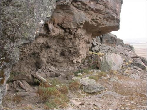
The upper part of Chiripascapa consists of one medium sized rock shelter and three small rock shelters at the base of an east-north-east facing portion of the Huarancante volcanic breccia lava flow escarpment. Below the rock shelters a sloping talus field (a 25° slope), littered with lithics as well as ceramics, leads to a small intermittent stream 20 vertical meters below the rock shelter. On the banks of this stream is a scatter of lithics and ceramics from a variety of time periods that extend downstream for approximately 300 m. The south bank of the stream has a modern estancia (Pausa) and a large corral below the associated buildings, seriously disturbing any artifact scatters on the south bank. The north bank of the stream is also disturbed. Large scars from bulldozers scraped off the topsoil in certain areas. The resident at the Pausa estancia explained that during the 1970s highway improvement for the Majes Project the road crews caused these impacts as they were looking for gravel sources in that area. Just north of this site complex is a large, active gravel pit.
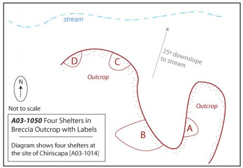
Figure 6-18. A03-1050 consists of four rock shelters: A, B, C, and D.
Figure 6-19. Chiripascapa [A03-1014], Archaic Foragers occupation.
A03-1050 - Four rock shelters of Chiripascapa
These rock shelters appear to be well situated with respect to the surrounding geography. The shelters face east-north-east and so despite being in a dark and slightly damp corner of the lava toe they catch the morning and midday sun. It is worth noting that the estanciadepicted in the center of the map appears to be deliberately built with the same aspect. The rock shelter is relatively well-hidden because it lies about 50m up a side quebrada and therefore goes unnoticed unless you climb the quebrada. Despite the concealed position, this location actually offers a partial view of the most important resource in the zone: the bofedal one km to the north-east. It would also be possible to monitor travel through the Ventanas del Colca access to the upper Colca from this hidden location. The stream below the shelters was dry at the end of the dry season, but probably flows most of the year.
Due to low GPS reception in the rock shelter area the four rock shelters were mapped as a single Struct-L line "A03-1050" and differentiated as A, B, C, and D. Only one shelter, the one designated as A03-1050B, had the characteristics of a residential shelter. The dimensions of this shelter are as follows. Height:2m, Depth:6.5m, Width:7m. Due to the overhanging roof formed from the lava flow, a considerable area is dry outside of the walls of the cave. This area shows signs of having been improved as a patio and the "patio" area extends the depth of the dry zone by another 12.5m. The rock shelter 1050A was large but wet, and 1050C and 1050D were very small but dry.
Below the rock shelters a talus slope extends approximately 20 vertical meters to the stream. A variety of lithics and ceramics were identified on this slope, though only one projectile point was diagnostic to a period that falls in the Archaic Foragers timespan. This point [A03-1051] was a Middle Archaic andesite point and it had a transverse snap and missing its haft element, suggesting that it was broken in use.
Features and Artifacts
The stream enters the open, sandy soils of the pampa and on either bank of the stream, though primarily on the north bank, projectile points from throughout the Archaic sequence were found. Preservation is relatively poor on this section of the pampa. In addition to the bulldozer impacts mentioned above, the soils appear deflated and this partly explains the high density of projectile points, from virtually every time period, found in this area. It seems possible that the entire site scatter was formerly more aggregated on the western part of this map, and with riverine transport the artifacts have been scattered over the pampa.
|
ArchID |
Artif. # |
Material |
Form |
Type |
Temporal |
|
1015 |
1 |
Obsidian |
Proj Point Broken |
1a |
Early Archaic |
|
1016 |
1 |
Obsidian |
Proj Point |
2c |
Middle Archaic |
|
1017 |
1 |
Volcanics |
Proj Point Broken |
4d |
Late Archaic |
|
1018 |
1 |
Volcanics |
Proj Point |
4d |
Late Archaic |
|
1019 |
1 |
Volcanics |
Proj Point |
3d |
Archaic |
|
1021 |
1 |
Volcanics |
Proj Point Broken |
2c |
Middle Archaic |
|
1023 |
1 |
Obsidian |
Proj Point |
2c |
Middle Archaic |
|
1024 |
4 |
Volcanics |
Proj Point |
4d |
Late Archaic |
|
1024 |
5 |
Volcanics |
Proj Point Broken |
4d |
Late Archaic |
|
1026 |
3 |
Obsidian |
Proj Point |
1b |
Early Archaic |
|
1031 |
1 |
Obsidian |
Proj Point |
4f |
Late-Term. Archaic |
|
1034 |
1 |
Chert |
Proj Point |
1b |
Early Archaic |
|
1035 |
1 |
Obsidian |
Preform |
2c |
Middle Archaic |
|
1036 |
1 |
Obsidian |
Preform |
2c |
Middle Archaic |
|
1037 |
1 |
Obsidian |
Proj Point |
1a |
Early Archaic |
|
1044 |
1 |
Obsidian |
Preform |
2c |
Middle Archaic |
|
1044 |
2 |
Obsidian |
Proj Point |
1a |
Early Archaic |
|
1048 |
1 |
Volcanics |
Proj Point |
4d |
Late Archaic |
|
1051 |
1 |
Volcanics |
Proj Point Broken |
3b |
Middle Archaic |
|
1057 |
1 |
Volcanics |
Proj Point Broken |
4f |
Late-Term. Archaic |
Table 6-27. Diagnostic Series 1 through 4 projectile points from Chiripascapa [A03-1014].
The temporal distribution of projectile points from Chiripascapa shows that virtually every time period is well represented. One distinction worth noting is that obsidian is used almost exclusively in the later time period, while about 50% of the projectile points (by count) are made from obsidian in the early time periods presented by Series 1 - 4 points.
|
Projectile Points |
Obsidian |
Volcanics |
Chalcedony |
Chert |
|
Series 1 - 4 |
10 (48%) |
9 (43%) |
1 (5%) |
1 (5%) |
|
Series 5 |
24 (96%) |
1 (4%) |
0 |
0 |
|
Total |
34 |
10 |
1 |
1 |
Table 6-28. Representative proportions of material types by projectile point styles.
The medium and high density lithic loci along the creek banks are difficult to temporally isolate because there are later period diagnostics, including twenty-six Series 5 projectile points and ceramics dating from the Middle Horizon, LIP, and Inka periods found in the A03-1038 lithic locus. Most of the flakes observed at this site were obsidian and chert. A small concentration of andesite flakes on the south bank of the stream in locus A03-1038 was observed, despite the fact that all andesite projectile points came from the north bank of the stream.
|
Material Type |
Obsidian |
Volcanics |
Chalcedony |
Chert |
Quartzite |
|
No. |
88 (62%) |
32 (23%) |
5 (4%) |
15 (11%) |
1 (0.7%) |
|
Mean Wt (g) |
5.05 |
18.28 |
16.7 |
10.91 |
11.5 |
|
% by Sum Wt |
34.5% |
45.6% |
6.7% |
12.3% |
0.9% |
Table 6-29. All lithic artifacts from Chiripascapa.
The surface materials included bifaces, cores, and flakes of all local material types except quartzite, which was rare at the site. Based on the mean flake size and the percentage of the total contribution by weight, fine-grained volcanics appear the most local to the area. Isolating any one of the lithic concentrations to a particular time period is difficult, but when viewed collectively including the point scatters in A03-1014 and A03-1025, and the rock shelters in A03-1049, the site complex is one of the oldest residential areas in the larger study area. The rock shelter A03-1050B and the built up patio has a high probability of containing a stratified intact deposit that extends into the earlier parts of the Archaic.
A03-900 "Huañatira"
Huañatira is a horseshoe-shaped valley with escarpments of lava flows of volcanic breccia on three sides and a small rise in the center where a single toe of lava extends down lower towards the pampa. The result is a sheltered, circular valley with a sloping ramp that climbs towards the top of the lava flow to the east of the valley. The Huañatira valley provides a moderately sheltered area with good views of the surrounding pampa, and it is defensive because it provides means of escaping to the higher lava flow terrain without being observed by pedestrians approaching from the pampa.
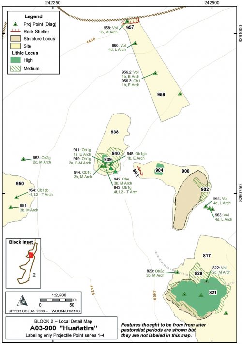
Figure6-20. Huañatira [A03-900] and vicinity, Archaic Foragers occupation.
Description
The area has evidence of occupation from virtually every time period from the Early Archaic to the modern period. A maintained estancia is found just to the west of the study area shown in Figure 6-20, and a small driveway is shown on the map accessing the area from the east. A worn trail departs the estancia to the west; a travel route that probably dates to the pastoral period if not earlier. Projectile points were found scattered around the valley that date to all periods, however most of the large scale archaeological features in this area appear to be from the pastoralist period. The circular or oval features shown as structural loci (not labeled on Figure 6-20) are most likely of pastoralist origin. A rock shelter offering partial protection was found in the center of site 900 overlooking the pampa [A03-903]. This immediate valley area belongs to a very small local watershed, and during the dry season there was no apparent surface water. This small watershed prevented a great deal of surface runoff; a factor has probably helped to maintain artifact positions in their original contexts in this local valley more than at other sites from the survey.
|
ArchID |
File Type |
ArchID (cont.) |
File Type |
|
|
817 |
site_a |
940 |
lithic_a |
|
|
820 |
site_p |
941 |
lithic_p |
|
|
821 |
lithic_a |
942 |
lithic_p |
|
|
822 |
site_p |
943 |
lithic_p |
|
|
823 |
site_p |
944 |
lithic_p |
|
|
824 |
site_p |
945 |
lithic_p |
|
|
825 |
site_p |
946 |
lithic_p |
|
|
826 |
site_p |
947 |
lithic_p |
|
|
827 |
site_p |
948 |
site_p |
|
|
828 |
lithic_a |
949 |
lithic_p |
|
|
830 |
struct_p |
951 |
lithic_p |
|
|
831 |
site_p |
953 |
lithic_p |
|
|
900 |
site_a |
954 |
lithic_p |
|
|
902 |
lithic_a |
956 |
site_a |
|
|
903 |
struct_l |
957 |
struct_l |
|
|
904 |
lithic_a |
958 |
struct_a |
|
|
905 |
lithic_p |
960 |
lithic_p |
|
|
906 |
site_p |
961 |
lithic_p |
|
|
907 |
site_p |
962 |
lithic_p |
|
|
938 |
site_a |
963 |
lithic_p |
|
|
939 |
lithic_a |
964 |
lithic_p |
Table 6-30. Non-consecutive ArchID numbers at Huañatira [A03-900], an Archaic Foragers site.
A03-957 - Rock shelter
This is a relatively large rock shelter overlooking the pampa and the valley of Huañatira. Contrary to most residential rock shelters in the region, this shelter faces south-east and it is therefore not exposed to the warming sun and was probably a shelter that was cool in temperature nearly all year reducing its potential as a residential structure in the altiplano. The shelter offers a relatively large amount of residential space inside the dripline; the rock shelter is 7m deep from the dripline, 12m wide, and over 3m high. Virtually all of the interior space of the shelter is clear of rubble and useable for residential activities. Four projectile points from the Early, Middle, and Late Archaic Periods were found associated with this shelter. A recessed tomb dominates this shelter today, but given the size of the feature and the pattern of cave burial during the Late Intermediate Period, the mortuary feature in this shelter is interpreted as a LIP cist tomb. These features are described in the Late Prehispanic - Block 2 discussion (Figure 6-76), close to the end of this chapter.
Figure 6-21. Rock shelter of Huañatira with circular mortuary feature visible inside. One meter scale showing on tape resting on rock along dripline (see also Figure 6-76).
Features and Artifacts
Some cases of disturbed artifact provenience are obvious, such as the three projectile points in a wash at the base of the valley shown as the three points on the eastern edge of Figure 6-20. Also the points below the Huañatira rock shelter on the north end ofthis site were found in the colluvial zone below the shelter and were apparently displaced.
|
ArchID |
Index# |
Material |
Form |
Type |
Temporal |
|
820 |
1 |
Obsidian |
Proj Point |
3b |
Middle Archaic |
|
822 |
1 |
Volcanics |
Proj Point |
2c |
Middle Archaic |
|
941 |
1 |
Obsidian |
Proj Point |
1a |
Early Archaic |
|
942 |
1 |
Chert |
Proj Point Broken |
3b |
Middle Archaic |
|
943 |
1 |
Obsidian |
Proj Point |
4f |
Late - Terminal Archaic |
|
944 |
1 |
Obsidian |
Proj Point |
3b |
Middle Archaic |
|
945 |
1 |
Obsidian |
Proj Point |
1b |
Early Archaic |
|
949 |
1 |
Obsidian |
Proj Point |
2a |
Early-Middle Archaic |
|
951 |
1 |
Quartzite |
Proj Point |
3b |
Middle Archaic |
|
953 |
1 |
Obsidian |
Proj Point |
2c |
Middle Archaic |
|
954 |
1 |
Obsidian |
Proj Point |
4f |
Late - Terminal Archaic |
|
956 |
2 |
Volcanics |
Proj Point Broken |
1b |
Early Archaic |
|
956 |
3 |
Obsidian |
Proj Point Broken |
1b |
Early Archaic |
|
958 |
1 |
Volcanics |
Proj Point Broken |
3b |
Middle Archaic |
|
960 |
1 |
Volcanics |
Proj Point |
4d |
Late Archaic |
|
963 |
1 |
Volcanics |
Proj Point Broken |
4d |
Late Archaic |
|
964 |
1 |
Volcanics |
Proj Point |
4d |
Late Archaic |
Table 6-31. Diagnostic Series 1 through 4 projectile points from Huañatira [A03-900].
Artifact proportions are consistent with other Archaic Foragers sites in the area, with approximately 50 of the projectile points and 65 of all collected lithic artifacts being of obsidian. A number of bifaces and flakes were found at this site, primarily of fine-grained volcanic stone and obsidian, and one obsidian core.
|
Material Type |
Obsidian |
Volcanics |
Chalcedony |
Chert |
Quartzite |
|
No. |
50 (64%) |
14 (18%) |
3 (4%) |
9 (12%) |
2 (3%) |
|
Mean Wt (g) |
4.97 |
99.8 |
31.4 |
49.5 |
111.1 |
|
% by Sum Wt |
10.4% |
57.8% |
4.2% |
17.6% |
9.9% |
Table 6-32. All lithic artifacts from Huañatira.
As with other residential areas in Block 2, it is difficult to differentiate the Archaic Foragers component in this area of heavy reoccupation. The area contains a large rock shelter and it provides a measure of shelter on the border of the pampa, as do the other shelters in the area. Several Late Archaic projectile points are dark fine-grained volcanic rock, akin to the Late Archaic (4d) points found at that Chiripascapa [a03-1014] a short distance to the north.
Site Type: Sites with majority non-obsidian lithics
A substantial Archaic presence in Block 2 takes the form of diffused, low density scatters with associated diagnostic projectile points along the edge of the pampa and frequently close to water sources. These finds are very difficult to differentiate from the pastoralist site occupation pattern and therefore these features will be described as a group, followed by generalizations about the characteristics of the environmental and cultural features of sites of this type in Block 2.
While the Archaic Foragers use of space largely overlaps with pastoralist occupation areas in Block 2, the use of lithics appears to differentiate the two. As was discussed in Chapter 3 (Section 3.4.4), the use of obsidian for projectile points expands dramatically at the end of the Archaic Foragers period both near the Chivay source and in the consumption zone.
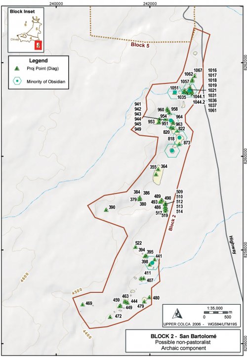
Figure 6-22. Block 2 Archaic Foragers component from lithic evidence.
Method
The criteria used here for sites isolating through the dominance of particular material types are as follows for both lab analysis Lithics_I and Lithics_II. First, the lab results by SiteID (or isolated ArchID), showing count and percent, were shown in a table against material type in Arcmap. This table was joined to the All_ArchID_Centroids point geometry [link to Processing in Ch 5] so that lab results for lithic material types were aggregated by site or isolate. These features were then filtered by constructing a query where the artifact count for a geographical feature had to be greater than 5 so that relative percentages were meaningful. Finally, the index symbolized inFigure 6-22 is the Lithics_I lab results (the most comprehensive table) where Percentage of Non-obsidian lithic artifacts is greater than or equal to 50%.
Results
The use of non-obsidian materials such as chert, chalcedony, and especially fine-grained volcanic materials, dropped precipitously during the Terminal Archaic at sites in Block 2. While all lithic material types persist in use during the pastoral period, the herd management tasks of butchery and shearing appear to have been largely conducted using obsidian. Reviewing the percentages of sites with strong evidence of a pastoralist occupation (only Series 5 projectile points, a corral, water, and grazing opportunies) these sites commonly have between 20% - 40% non-obsidian flaked stone. Thus, the distinction between pastoralist and forager components based on material type is not firm, but the distributional pattern is reinforced by non-series 5 projectile point distributions, and this evidence is shown together in Figure 6-22.
Six sites have been identified with a relatively robust Archaic Foragers component in Block 2 and the environmental characteristics of these six sites will be compared with all locational characteristics of B2 sites in order to look for patterning among the environmental criteria of Archaic Foragers sites. These six sites include the following A03- 396, 884, 894, 900, 1014, 1049 and while diagnostics from the Archaic Foragers period were widely encountered throughout the region, these sites are selected as representantive for the larger Archaic Foragers time period and life way based on inference. Clearly the boundaries of the "site" are probably not coterminous with the Archaic Foragers component of these sites, nevertheless these measures serve as a general indicator of changes in the environment context of settlement through time.
|
Selectedm |
Selecteds |
All B2 Sitesm |
All B2 Sitess |
All B2 Sitesm - Selectm |
|
|
Altitude (masl) |
4382.6 |
12.69 |
4393.2 |
25.7 |
-10.6 |
|
Slope (degrees) |
7.86 |
8 |
8.33 |
6.34 |
-0.47 |
|
Aspect (degrees) |
146.5 |
96.4 |
138.4 |
58.23 |
8.1 |
|
Visibility/Exposure |
33.6 |
13.1 |
40.1 |
25.53 |
-6.5 |
|
Dist. to Bofedal (m) |
497.3 |
212.2 |
307.5 |
261.5 |
189.8 |
Table 6-33.Environmental characteristics of selected Archaic Foragers sites in Block 2.
The high standard deviation values in the Table 6-33 "Selected sites" underscores the variability and inconsistency in these estimates. This comparison shows that the Archaic Foragers sites tend to be more sheltered/lower visibility than the pastoralist sites. As was previously noted, the Archaic Foragers sites are often adjacent to overlooks but the sites often do not occupy the high exposure area specifically. Archaic Foragers sites are considerably further than average from bofedales. This strong tendency in the data is probably accentuated by the intensification and maintenance of pastoral resources that has occurred in recent years. That is to say, as pastoralism is today the principal economy activity in the area, bofedales and attendant pastoral facilities have been well-maintained in the recent past, which is the criteria from which bofedales were selected from the ASTER satellite imagery for this measure. A further issue with respect to distance to water is the fact that many of the potential forager sites are adjacent to small streams that were probably seasonal and appear as dry in the modern dry-season ASTER imagery.
Discussion
Block 2 survey area represents a transition from the rugged lava flow topography on the west side of the block to the open pampa on the east side of the block. In addition, residents in the Block 2 area are able to exploit the higher density off resources in the puna while maintaining access and, perhaps, social relationships with residents in the adjacent lower altitude portions of the Colca valley.
A number of obsidian projectile points in this area were produced in the same general forms as chert points and, particularly, as fine-grained volcanic points. These forms are most akin to those documented at Sumbay, 30 km to the south. Given the greater local variability in point forms during the Late Archaic (Klink and Aldenderfer 2005: 53), the data from the Block 2 area provides an opportunity to study the local projectile point styles, best known from the Sumbay style points, in conjunction with the regional interaction documented through obsidian distribution data.
6.3.3. Block 3 - Archaic Callalli and adjacent valley bottom areas
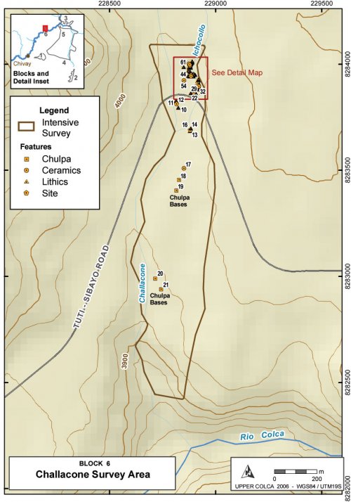
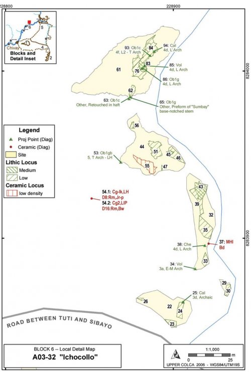
The 2003 field season evidence shows that the Archaic Foragers period use of the river valley and adjacent puna appears to have been relatively light in comparison with the occupation in the B2 - San Bartolomé area. Diagnostic projectile points and aceramic sites represent the only strong evidence of Archaic Period occupation in Block 3 since only test excavations in B3, at the site of Taukamayo [A03-678], were dated to the early part of the Middle Horizon.
Projectile point distributions
The strongest evidence of human activity during the Archaic in the Upper Colca valley segment of the survey comes from projectile point distributions.
|
Period |
Point Type |
Obsidian |
Volcanics |
Chalcedony |
Chert |
|
Archaic |
3d |
599, 1080 |
25 |
10, 670, 810 |
|
|
E-M Arch |
2a |
1078 |
599.4 |
||
|
3a |
1001 |
34 |
|||
|
M Arch |
2c |
790.3 |
|||
|
3b |
1007 |
810.2 |
|||
|
Latter part of M Arch |
2b |
1002 |
|||
|
L Arch |
3f |
1099 |
|||
|
4d |
86 |
85, 1008 |
94 |
38 |
|
|
L2 - T Arch |
4f |
93, 809 |
Table 6-34. Diagnostic Projectile points Series 1-4 from Blocks 3, 6 and the valley portion of Block 5 identifed by ArchID number.
Projectile point counts shown in Table 6-34 include the Upper Valley areas of Block 3 and Block 6, and the counts also include projectile points from Kakapunku [a03-1000] that lay in the valley bottom segment of Block 5 on the perimeter of Block 3. The Upper Colca valley segment of the survey had relatively low numbers of Early, Middle, and Late Archaic Period occupation evidence as compared with other segments of the survey. As is evident from projectile point counts, only 26 of the 56 projectile points (46%) from this Upper Valley derive from the Archaic Foragers period, a 5700 year long time period.
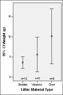
Obsidian projectile points are well-represented throughout prehistory, although over half are Series 5 points from the Terminal Archaic and onwards. It is notable that obsidian is so well-represented in finished projectile point material types because evidence of production or maintenance in the form of obsidian flaking debris is far less common than chert in this area. Chert is found in the riverbeds in Block 3 and therefore it is the predominant local material. However, among projectile points in Block 3 obsidian predominates in all point styles except type 3D where obsidian is a close second. By count, obsidian is most frequent, but by weight obsidian points are smaller even if Series 5 point types are excluded.
Figure 6-23. Projectile Point weights and lengths (when complete) by material type for Block 3, Block 6 and adjacent valley areas of Block 5. Series 5 points are excluded and chalcedony is included with chert.
The projectile points made from the immediately-available chert material type are larger than points of either obsidian or fine-grained volcanics (andesite). The difference in mean weights was assessed using the Kruskal-Wallis non-parametric test because the distributions were not normally distributed. The Kruskal-Wallis test showed that the observed difference in means between the three groups is significant (c2= 8.235, .01 > p> .05).
Block 3 Archaic Foragers Archaic Settlement Pattern
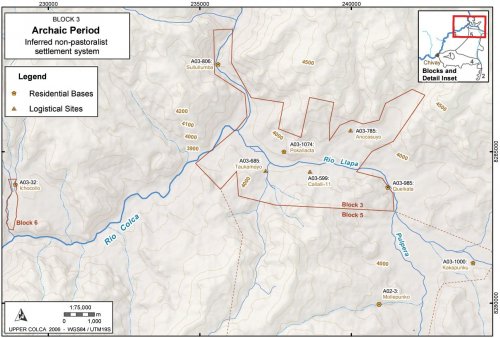
Archaic Foragers sites in the B3 portion of the survey can be grouped into three categories of sites. For Archaic sites these categories generally correspond with socio-economic activity and lithic provisioning, as indicated by lithics observed during fieldwork and representative grab samples collected from the surface. The three categories of sites include: (1) large, sheltered base camps; (2) small logistical camps, and (3) chert provisioning and initial reduction locations along river banks. These three groups will be discussed, along with the specific characteristics of major sites in each group, and subsequently the isolated or uncategorized sites will be described.
Figure 6-24. Archaic Period in Blocks 3, 6 and 5 (valley): Sites described in the text.
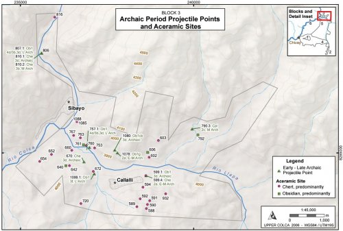
Figure 6-25. Block 3: Early, Middle, and Late Archaic projectile points and Aceramic sites.
A number of aceramic sites were difficult to differentiate from ceramic period sites and thus an comprehensive map, showing all of the potentially pre-pastoral sites, is depicted in Figure 6-25. Inclusively, this group includes most aceramic sites and locations with projectile points diagnostic to the Early, Middle, or Late Archaic Periods.
Site Type: Sheltered base camp
A03-1000 "Kakapunku" [A03-1000 - A03-1013]
The site of Kakapunku [A03-1000] (a.k.a. C'oponeta) is located on the south side of the Río Llapa on a north facing bluff just upstream of the confluence of the Río Llapa and the Río Pulpera. This site consists of three rock shelters spaced about 15m apart along the base of a 10m high irregular cliff band that lies approximately 30m up the hill and south of the high-water line on the Río Llapa. There is a colluvial ramp below the rock shelters and on a terrace below that ramp lie number of lithic loci and some ceramics. The rock shelters are generally north facing so that they are oriented to the mid-day sun and the shelters are warm and well-lit.
|
ArchID |
SiteID |
FileType |
Description |
Area (m2) |
|
1000 |
1000 |
Site_a |
"Kakapunku" |
3400.0 |
|
1004 |
1000 |
Lithic_a |
High Dens, ~70 Obs |
1771.3 |
|
1010 |
1000 |
Lithic_a |
High Dens, ~70 Obs |
76.7 |
|
1013 |
1000 |
Lithic_a |
Medium Dens, ~70 Obs |
148.6 |
Table 6-35. Loci in Kakapunku [A03-1000].
|
ArchID |
Description |
Height |
Depth |
Width |
Width Entrance |
|
A03-1001 |
Mortuary, looted. MNI=7 |
1.6 |
3.2 |
5.2 |
1.9 |
|
A03-1002 |
Domestic, warm rock shelter |
4 |
3.5 |
6 |
5.1 |
|
A03-1003 |
Mortuary, looted. MNI=14 |
1.6 |
~8 |
1.4 |
1 |
Table 6-36. Rock shelters at Kakapunku [A3-1000], dimensions in meters.
Figure 6-26. Site of Kakapunku [A03-1000].
A03-1001 -East rock shelter at Kakapunku
This is a looted mortuary context. The rock shelter is moderately difficult to access on a cliff face, and the entrance appears to have been formerly walled off. The original rock shelter height is difficult to determine because cist tombs in the floor of rock shelter have been excavated by looters. A number of complete crania and long-bones were present. The crania and long bones were examined in the field by Mirza del Castillo, a team member who is a physical anthropologist. From her in-field visual assessment she cautiously suggests that a number of the crania had female metric proportions, and that a number of the crania appeared to have hypoplasia of the bone marrow on the posterior edge of the parietal bones which is a possible indicator of anemia.
Figure 6-27. The entrance of A03-1001 with looted cist tomb visible inside the rock shelter.
A03-1002 - Center rock shelter at Kakapunku
This rock shelter is relatively shallow but other characteristics made it appear to be to be an inviting residential location for a small group of foragers or pastoralists. The shelter is dry inside the dripline, north facing, flat interior, defensible, a short distance from water, and immediately south of a terrace for open-air activities where loci a03-1004 through 1013 are located.
A03-1003 - West rock shelter at Kakapunku
This rock shelter is a lava tube sloping upwards into the cliff face. It appears to contain many disturbed interments. Undisturbed human remains perhaps exist here but they were not visible on the surface.
Discussion
Kakapunku is another case of a multicomponent site where discerning the Archaic component is difficult. Five projectile points were identified belonging to different Archaic Periods, and combined with the ceramics (described later), there is a some affiliation with virtually all time periods at this site.
|
ArchID |
Index |
Material Type |
Form |
Type |
Temporal |
|
1001 |
1 |
Obsidian |
Proj Point |
3a |
Early-Middle Archaic |
|
1002 |
1 |
Obsidian |
Proj Point |
2b |
Latter part of Middle Archaic |
|
1004 |
1 |
Obsidian |
Biface |
n/a |
|
|
1004 |
2 |
Obsidian |
Biface |
n/a |
|
|
1004 |
3 |
Obsidian |
Proj Point Broken |
5 |
Late |
|
1005 |
1 |
Volcanics |
Core |
n/a |
|
|
1007 |
1 |
Obsidian |
Proj Point |
3b |
Middle Archaic |
|
1008 |
1 |
Volcanics |
Proj Point |
4d |
Late Archaic |
|
1009 |
1 |
Obsidian |
Preform |
5a |
Late |
|
1010 |
1 |
Obsidian |
Proj Point Broken |
5d |
Late |
Table 6-37. Selected Lithics from Kakapunku [A03-1000].
On the terrace below the rock shelter [A03-1002] the largest concentration of artifacts were noted. Samples collected from the medium and high density lithic loci on the terrace are approximately 50% obsidian materials with the non-obsidian primarily consisting of aphanitic volcanic stone. The northern high density locus, A03-1010, is eroding down the cutbank caused by erosion and it is possible that this terrace was significantly larger but has been truncated by fluvial erosion of the terrace. In sum, Kakapunku appears to have served as a regular residential area with three relatively small rock shelters.
A03-985 "Quelkata"
This rock shelter lies just below the confluence of the Río Llapa and Río Pulpera along a sweeping bend in the river channel where the Río Llapa first approaches the Castillo de Callalli formation. This rock shelter is well situated and probably served as a residential base through most of prehistory, however surface collections by Jose-Antonio Chávez Chávez (1978) for his Bachelor's thesis revealed primarily preceramic occupation levels with late, Series 5 projectile points. By the time Chavez was able to systematically investigate the materials in the rock shelter it had been largely destroyed in 1976 by the road construction crews associated with the Majes Project (Chávez 1978: 3). The rock shelter was dynamited because it is unfortunately located precisely at a point of the Río Llapa where the project planned to build a bridge on the road to the Condoroma reservoir. What remains today of the rock shelter is a concavity in the tuff with a shelter dry zone measuring approximately 150m wide inside the dripline. Chávez systematically collected and analyzed projectile points from this rock shelter but, curiously, the artifactual evidence available shows an occupation sequence going only as far back as the Terminal Archaic.
Figure 6-28. Cueva de Quelkata was dynamited by Majes Project road crews in 1976. Two people are visible for scale inside the shelter to the left of center.
Figure 6-29. Quelkata in 1975 redrawn from Chavez (1978: 20). Red dotted line shows estimated border of the portion of the rock shelter that remains after the dynamiting for road widening.
Description
The rock shelter was significantly larger in the recent past. Chavez (1978: 20-21) estimates that the dry portion of the rock shelter was 7m deep, 50m wide, and 2.65m high at the mouth. The sheltered area amounted to a 365 m2area with the bulk of cultural debris concentrated in the south portion of the rock shelter. Chávez estimated that the stratigraphy included up to 3m of cultural material. During the 2003 season a great abundance of cultural material was not observed in the slopewash between the highway and the river, as one might expect if the highway were constructed on such quantities of cultural fill, but the area has been much disturbed in recent years.
Figure 6-30. Quickbird satellite image of Quelkata area in 2005. The shelter is under the tuff outcrops immediately to the left of the bridge. Data courtesy of Google / Digital Globe.
Quelkata is located at a major cross-roads in the local transportation network and it has probably been a significant landmark among people in the Upper Colca since the earliest human occupation of the region. The rock shelter mouth opens east-north-east and deposits still evident in the back of the rock shelter are approximately 5 vertical meters above the river and 2.5 meters above the modern highway. As the rock shelter is on a bend in the river the shelter appears to have been scoured out of the outcrop of welded tuff by the waters of the Río Llapa until the river channel was sufficiently incised that it not longer entered the rock shelter proper. Recently Noble (2003) collected a K-Ar sample from precisely this location and the resulting age of 20.7±0.6 million years indicates that the formation dates to the Early Miocene.
Geographical attributes of this location can be summarized as follows.
(1) Quelkata is a large, sheltered site close perennial to water source that probably provides year-round fishing opportunities.
(2) The east-north-east aspect results in warming by the morning sun.
(3) It is located at major intersection in local travel routes which suggests that many were familiar with the site, but also exposes the occupants to anyone traveling in this portion of the valley.
(4) Summits of the "Castillo de Callalli" tuff outcrops immediately above are defensible and appear to have been fortified during the LIP.
|
Figure 6-31. A 65cm column of cultural deposits still exists at the back of Quelkata at a height of approximately 1.8m above datum (at head height between the gravels and the tuff in photo). |
Preservation of Quelkata
Road crews associated with the Majes Project dynamited the rock shelter in 1976 but this was not the first important disturbance in this high traffic area. Significant impacts on preservation at Quelkata are the following
(1) Although the rock shelter lies approximately 5 meters above the dry season water level of the Río Llapa, the rock shelter has probably been scoured repeatedly by high water in past millennia. Quelkata is located on the outer edge of river bend precisely at a channelized portion of the river where 1000 year or even 100 year floods potentially entered the rock shelter and disturbed the contents.
(2) As noted by Chávez (1978: 17) a road has long existed in this area due to the fact that it is a crossroads location and, as a channelized portion of the river, it probably has had bridges prior to the modern bridge construction. With the mining history in the Cailloma area, a road was likely constructed to connect this ore-rich province with the Sumbay railroad sometime in the early 20thcentury. The dynamiting by the Majes crew was intended to widen the road at the bridge and the intersection, and it significantly impacted the rock shelter. However, the downslope colluvial outwash from the rock shelter, which are frequently deposits of great archaeological interest from a rock shelter, had long been disturbed by road construction and by fluvial erosion prior to the destruction by the Majes crew.
(3) The construction crews dynamited the site in 1976 and largely destroyed the southern portion of the rock shelter, the portion that Chávez (1978) describes as having the deepest deposits. There are still significant deposits at the back of the rock shelter, however. As part of the archaeological reconnaissance of the Llapa valley materials systematically surface collected from the rock shelter as will be described below.
(4) The intersection and bridge at Quelkata was a principal junction in the Arequipa highway network until 2002 when the highway connecting Arequipa with Juliaca was paved. Until the asphalting of the Arequipa-Juliaca highway virtually all of the highway traffic between Arequipa and Cusco passed directly in front of this rock shelter where one of the few restaurants and gas stations along the route was located. Thus, a relatively high number of travelers probably visited the rock shelter and its surroundings while waiting for transportation. Fortunately, the dynamiting of the shelter created a sheer 2 m wall so that a brief segment of 4thclass rock climbing is required to enter the rock shelter, discouraging casual visitors.
There are still cultural deposits in a broad but thin and shallow section at the back of Quelkata. While much of the strata along the back of the rock shelter are disturbed sand and river gravels, a cultural level approximately 60cm deep is found across a swath approximately 40m wide at the back of the rock shelter.
Figure 6-32. Profile of extant deposits at Quelkata shown in terms of relative collection units.
Proveniencing
As GPS cannot function in rock shelters, a collection strategy was devised using a datum inside the rock shelter. First, the shelter area was mapped expediently using tape and compass from a semi-permanent datum established on large rock on the north end of the occupation area near the road cut. Artifacts were surface collected from Quelkata in four horizontal collection units that were given ArchID# 986, 987, 988, and 989 to conform to the horizontal collection strategy throughout the survey. The deposits in the back of the rock shelter occurred on natural shelves and the vertical provenience was retained by collecting these shelves from the top (level 1) to bottom (level 5). The lowest level, the shelter floor, appeared to contain a mixture of materials that had cascaded down from above.
Site Collection
In the 2003 fieldwork season 22 flakes and retouched flakes from the rock shelter were collected. These consisted primarily of chert, chalcedony, and andesite. Of the 22 flakes 10 (45%) were made from obsidian, but these obsidian artifacts amount to only 7% of the flaked stone artifacts by weight. A number of bones and goat horns were among the faunal materials collected from the upper levels of the rock shelter, above the rock ledge. It is possible that the horns were placed in this location to dry out.
Chávez Collection
In his Bachelor's thesis José-Antonio Chávez (1978: 52-70) describes and analyzes surface collections that he conducted shortly after the dynamiting of the cave. Chávez includes photographs and drawings of projectile points that appear to be primarily of Type 5B and 5D forms. Chávez reports that he collected 36 projectile points and that the largest group was the concave base form (n = 17) that are probably Type 5B or Type 5D, diagnostic to the Terminal Archaic through the Late Horizon. Of these concave base forms 15 of them were made from obsidian (88%) and the remaining two were chert. Pressure flaking was noted on 16 of the points (Table 6-38).
|
Obsidian |
Non-obsidian |
Totals |
|
|
Unmodified |
434 |
150 |
584 |
|
Modified |
121 |
57 |
178 |
|
Total |
555 |
207 |
762 |
|
Percent |
72.8% |
27.1% |
100% |
|
P.Pt Base: Convex |
7 |
1 |
8 |
|
P.Pt Base: Flat |
8 |
0 |
8 |
|
P.Pt Base: Concave |
15 |
2 |
17 |
|
Probable Concave Base |
12 |
0 |
12 |
|
Cores |
2 |
3 |
5 |
|
Flakes - cortical |
4 |
12 |
16 |
|
Flakes - noncortical |
141 |
93 |
234 |
|
"Blades" |
57 |
40 |
97 |
|
"Choppers" |
5 |
5 |
Table 6-38. Counts of Material types by Artifact Form from 1977 Quelkata surface collections (Chávez 1978: 50-72).
A relatively large proportion of the points are non-diagnostic using Klink and Aldenderfer's typology. Three points described as "convex base" appear to be type 3D, a style which persists throughout the Archaic. Chávez notes that a large percentage of the artifacts were made of obsidian, although the identification of the Chivay source, 20 km to the south-west and 1000 meters in elevation above Quelkata, would not occur for another 15 years. Chávez attributes the relatively large percentage of obsidian to the many very small flakes of obsidian that were included in his sample. Had his analysis included weight of artifacts, the relative presence of obsidian by weight would have been considerably lower than that of other material types. It is apparent that obsidian was being transported to Quelkata and worked at the rock shelter from one of the Chivay obsidian source exposures in the study region.
Another notable pattern in these data is the lack of non-obsidian projectile points. This pattern is consistent with the predominantly base-notched (and Series 5) nature of this assemblage. However, results from the 2003 fieldwork show that this is anomalous in the region, even for the Terminal Archaic and onwards.
Discussion
Several of the projectile points that were noted on the top level of the rock shelter (in unit A03-988-level I) during a preliminary visit to the shelter in 2001 were gone from the rock shelter by the fall of 2003. The points required more careful study, but unfortunately this did not occur, and it was hoped that the points would have been retrieved during the course of the 2003 fieldwork.
It is notable that, despite the apparent importance of Quelkata in the regional settlement pattern, there were relatively few Archaic projectile points found in this rock shelter. Based on the evidence from Chávez and the 2003 examination of the rock shelter, the only definitive projectile point styles encountered at Quelkata are from the Terminal Archaic and onward. One parsimonious explanation for the lack of earlier projectile point styles is that the location of this rock shelter, only 5 m above the dry season water line, was insufficient to prevent particularly intense flooding during the Terminal Archaic which removed evidence from earlier time periods. Given data encountered at the site, this description of the Quelkata rock shelter perhaps belongs in the Early Agropastoralist discussion rather than the Archaic Foragers section of this dissertation. However, due to the centrality of this rock shelter in the settlement pattern, the shelter was likely a prominent settlement throughout the prehispanic period and thus it was included here.
A02-3 "Mollepunco"
The rock shelter of Mollepunco (aka Mollepunku, Cueva de Pirita) is one of the principal tourist destinations in the Upper Colca area (Cardona Rosas 2002: 143-147;Hostnig 2003: 52;Linares Málaga 1992: 287, 290, 291, 298) and it probably receives visitation by about ten groups of tourists per week during the high season. Formerly known as "Pirita" the shelter was renamed "Mollepunco" by Eloy Lináres Malaga in 1984 (1990;1992). This dry rock shelter at the base of a partly welded tuff outcrop consists of two principal cavities and with flat floors and sloping ceilings, and a dry outdoor activity area. The principal cavity is 7m deep, 4m wide, and 5m tall. The shelter is approximately 100 vertical meters above the Pulpera valley floor and it is adjacent to a small perennial stream. The shelter features pictographs and petroglyphs of camelid, bird, and humanoid figures that Augusto Cardona (2002: 143-147) argues are significant because they show the transition from pictographs to petroglyph techniques, and the art is believed to have been executed by herders and is therefore no older than 3000 BCE. The art has been interpreted as dating to relatively late periods because plump camelid figures are often shown in herds, and one solitary camelid has what appears to be a rope around its neck. The shelter was excavated by Linares (1992) and despite the gate blocking the entrance of one sector, it appears that the shelter was significantly looted. An open burial chamber probably dating to the LIP is evident high in the southern end of the rock shelter.
Figure6-33. Cueva de Mollepunco (A02-3).
Figure 6-34. Petroglyph of camelid on wall of Mollepunco.
Lithic debris is predominantly chert but a significant portion of the flaked material is obsidian. Bone and LIP ceramics are also evident at the site, perhaps resulting, in part, from the looted burial. Given the heavily visited and previously collected nature of this site surface the 2003 Upper Colca project field crew did not attempt a systematic recording of surface artifacts.
A03-1074 "Pokallacta"
This is a small, sheltered site that has evidence of occupations in both the Archaic Foragers period and subsequent times. The site is immediately to the west of a steep tuff outcrop approximately 100m high. The site is in the shadow much of the day, but it is a sheltered location that is protected and yet offers large views of the river valley.
The rock shelters are fronted by a flat area that today is a corral. This flat activity area is mapped as two Structure Loci though they are essentially one terrace. The two loci delimit the artifact spill zone for each respective rock shelter and each structure locus was assigned the same ArchID number as the rock shelter above it.
|
ArchID |
SiteID |
FileType |
Description |
Area (m2) |
|
1074 |
1074 |
Site_a |
"Pokallacta" |
4,342.7 |
|
1075 |
1074 |
Struct_a |
Southwest shelter |
63 |
|
1076 |
1074 |
Struct_a |
Northeast shelter |
45 |
Table 6-39. Loci in Pokallacta [A03-1074].
|
ArchID |
Description |
Height |
Depth |
Width |
Height At Back |
|
1075 |
Residential, pastoral |
2.5 |
9 |
10 |
1.2 |
|
1076 |
Residential |
2.2 |
6 |
5.3 |
0.9 |
Table 6-40. Rock shelters at Pokallacta [A3-1074], dimensions in meters.
|
ArchID |
Index |
Material Type |
Form |
Type |
Temporal |
|
1074 |
1 |
Obsidian |
Proj Point Broken |
5d |
TA - LH |
|
1074 |
2 |
Obsidian |
Biface Broken |
n/a |
|
|
1074 |
3 |
Obsidian |
Proj Point Broken |
5a |
Term Archaic |
|
1074 |
4 |
Volcanics |
Biface Broken |
n/a |
|
|
1075 |
1 |
Chalcedony |
Proj Point |
5 |
TA - LH |
|
1076 |
1 |
Obsidian |
Proj Point |
5b |
TA - MH |
|
1078 |
1 |
Obsidian |
Proj Point |
2a |
Early - Middle Archaic |
|
1080 |
1 |
Obsidian |
Proj Point |
3d |
Archaic |
Table 6-41. Selected Lithics from Pokallacta [A03-1074].
The bifacially flaked items are largely obsidian but notably the bulk of the grab sample of unmodified flakes was of chert and chalcedony. This reflects the location of the site on the north side of the Río Llapa, and is consistent with a raw material use pattern observed elsewhere on the survey.
A03-1075
This rock shelter has a very thick dung cap and it is difficult to see the ground. The slanting roof and open west side provides a large but only partly sheltered area. It appears that a protective wall was constructed on the west side in the past.
A03-1076
This rock shelter is the more protective residential shelter of the two, offering a view of the river valley and the surrounding terraces.
Site Type: Small logistical site / hunting blind
Given the weak evidence of Archaic occupation in the Block 3 area, traces of early logistical sites and hunting blinds were difficult to discern from the well-distributed pastoral period evidence. As described above, archaeological sites were judged to contain pre-pastoral components belonging to logistical sites and hunting blinds when assemblages were of low diversity and long term site occupation evidence was slight. Often such sites are hard to definitely characterize as "archaic logistical sites" because the sites were found in places that appeared to be either predominantly later occupation period, or they were situated in were from ridgelines and other relatively exposed, steep, and waterless locations that were judged to be relatively unsuitable for long-term residential occupation.
A number of sites fall into the category of logistical sites and hunting blinds because it is essentially a catch-all category of potential pre-pastoral behaviors that do not contain definitive evidence for later occupation, such as ceramics. However, during the wet-season herders in the Upper Colca area return to the valleys (Markowitz 1992) and the slopes above the city of Callalli become suitable grazing land. A herder tending the flock high on the slopes might knap stone and create an aceramic site far from pastoral facilities or bofedales. Thus, it is difficult to conclusively say that the Block 3 aceramic sites (shown in Figure 6-25) predate the Terminal Archaic; the aceramic distribution is presented here conditionally.
|
Sitem |
Sites |
Block 3m |
Block 3s |
Block3 m - Sitem |
|
|
Altitude (masl) |
3947.2 |
83.7 |
3984.5 |
87.45 |
+37.3 |
|
Slope (degrees) |
9.8 |
5.5 |
12.3 |
8.5 |
-2.5 |
|
Aspect (degrees) |
SE |
SE |
SW |
SE |
NE |
|
Visibility/Exposure |
38.3 |
24.2 |
39.1 |
23.4 |
+.8 |
|
Dist. to Bofedal (m) |
1420 |
600 |
1024.8 |
567.9 |
-395.2 |
Table 6-42. Environmental characteristics of aceramic sites.
An exploration of the environmental circumstances of these aceramic sites shows that the sites are found in higher altitude areas, relative to the terrain in Block 3, and the distribution are on relatively steep slopes for site locations. The highly variable aspect measure is not particularly informative, though it shows a slight tendency towards south-east exposures in a block that trends to the south-west. These sites are found in relatively exposed, high visibility areas, and they tend to be farther than average from bofedales, though on the whole bofedales are not widespread in Block 3. Examples of such sites would include a few that contain diagnostic pre-pastoral Archaic projectile points, but also appear to contain evidence of later occupations.
A03-599 "Callalli 11"
This site is on the east edge of Callalli just beyond a quebrada. A relatively dense scatter of flaked stone and projectile points from two Archaic styles and two later (Type 5) styles were found here, but the artifacts were not sufficiently dense to merit mapping as a low density lithic locus. The site is heavily disturbed by the construction of two roads on either side of it: the modern Callalli access road to the north and a narrow, steep road accessing the soccer field to the west and south of the site.
Figure 6-35. View westward from "Callalli 11" across quebrada shows the eastern edge of Callalli.
This deflated terrace edge area contained flakes approximately one half chert and one half obsidian by count, and 1/4 of the obsidian was cortical. A ground andesite hammerstone weighing 294 g and stained with ochre was also found here. This open air site area offers partial shelter in the form of the quebrada and associated lower terraces that are now destroyed by road construction. The quebrada probably contained water for part of the year.
Figure 6-36. Callalli 11 [A03-599] on terrace on the east edge of the town ofCallalli.
A03-785 "Anccasuyo"
Another possible logistical site was found away from the principal river channel in the area of the colonial site of Anccasuyo. A single type 1A (Early Archaic) or 2C (Middle Archaic) projectile point of chalcedony, broken at both ends, was found here. The temporal assignment is ambiguous because of the broken base. This location is adjacent to a small tributary to the Río Llapa and where an outcrop of tuff creates a small pool that has been developed into a stock pond.
|
Figure 6-37. Chalcedony projectile point [A03-790] from Anccasuyo [A03-785]. |
There were two obsidian flakes here, and five non-obsidian flakes. While the Archaic evidence from this site is small, a single point (that could have been scavenged from elsewhere by the colonial occupants), if the context is intact it represents a kind of peripheral, hidden habitation that one might expect to complement the larger residential bases elsewhere in the valley.
A03-675 "Taukamayo" (A02-26)
This area meets the criteria for a possible short term camp or logistical camp during the Archaic Foragers period. A red chert foliate projectile point was found just outside of the principal site of Taukamayo, a site that will be discussed in detail below. The chert point is probably type 3D (incomplete scar coverage) and it is of a style that is only diagnostic to the preceramic period. This location is a bench terrace that is relatively exposed topographically but, as with site A03-599 Callalli-11 there are opportunities for shelter nearby. This site is classified here this as a possible logistical camp during the Archaic because the immediate occupation appears relatively small and exposed for a residential base, but the evidence is conflated with quantities of flaked stone and pottery from later occupations. The site is positioned at the base of a principal access trail to the high country to the south, and close to the biggest river confluence in the region. In other words, there is not a lot of evidence of long term occupation or diversity of activities during the pre-pastoralist period at this site, but the location appears to be positioned strategically with respect to local travel corridors and the monitoring of the river confluence, and the site thus appears to have more than merely a chert procurement location.
Site Type: Chert provisioning site
A final site type category to be considered in this section is that of Archaic Period Block 3 provisioning and initial reduction sites. A relatively large number of sites are found on the lower terraces of major watercourses. The sites can be characterized as exposed, open air sites featuring cortical reduction debris where the majority of material is chert or chalcedony, and the tools are discarded bifacial tools and points. The process appears to have consisted of obtaining chert cobbles from the river bed during low water seasons and opening the cobbles in the riverbed to evaluate the knapping quality of the material. Some percentage of cobbles deemed suitable for further reduction were then transported to the terrace above, where knapping occurred. Sites rich in chert were not exclusively encountered on these river bank areas, but these production sites were abundant in cortical material and the mean flake sizes were relatively large.
These kinds of sites were encountered most frequently on the very edges of terraces but this was perhaps due in part to the greater visibility from erosion along the terrace margins. The sites are otherwise exposed and appear to have been an unlikely place for residential occupation. The profiles of cut banks were investigated at some of these sites and stratified deposits were rarely observed eroding from the cutbanks. The 2003 season survey did not encounter chert raw material in its original geological context, it was only found in the bed of streams in the Block 3 area. As a consequence, it appears that most of the chert artifacts recovered during the 2003 season were probably knapped along these river terrace margins, and it is difficult to assign a time period to these early production sites. There was no strong patterning with the temporally diagnostic point styles and the material types used in Block 3 during the Archaic Foragers period. Points were made from chert and obsidian in Block 3 throughout the Archaic and obsidian points were frequently found on river terrace margins surrounded by chert knapping debris.
A03-806: Sullullumba
A good example of a river terrace provisioning site with evidence of multiple Archaic Period occupations is "Sullullumba" [A03-806]. This site was the only site with purely Archaic occupations in Block 3. It is located up the Colca river from the confluence at Sibayo, and is therefore one of the areas furthest in the study area from the Chivay obsidian source. The site is located on a pronounced terrace edge on the inside bank of a broad bend in the Colca river. Under modern conditions, the area is exposed both to valley winds and by the fact that it lies on the edge of a 40 m steep downslope to the annual high water mark in the river channel.
Figure 6-38. Map of the Sullullumba [A03-806], an Archaic Foragers site showing lithic loci on terrace edge 40m above the annual flood line. Image courtsey of Quickbird DG / Google.
Figure 6-39. Sullullumba [A03-806] along terrace edge above the upper Río Colca. Yellow notebook and scale bar are visible in the center-rear of photo.
|
ArchID |
SiteID |
FileType |
Description |
Area (m2) |
|
806 |
806 |
Site_a |
Sullullumba |
366.6 |
|
807 |
806 |
Lithic_a |
Medium Dens, 10 Obs |
169.6 |
|
808 |
806 |
Lithic_a |
High Dens, 10 Obs |
21.3 |
Table 6-43. Loci at Sullullumba [A03-806].
Artifact analysis from Sullullumba
As one of the only single component Archaic Forager sites, seventy-four artifacts collections from this site were given thorough attention in lab analysis. The items below indicate the kind of lithic reduction that occurred on river terraces some distance from the Chivay source.
Obsidian
Obsidian material consisted of two types: clear and clear-banded flakes with no heterogeneities, and grey and black shaded obsidian with heterogeneities. Two broken projectile points and one broken biface were made from obsidian that is presumably of Chivay type material. A single flake of clear obsidian was found highly rotated and with 20% dorsal cortex, placing it at a mid-stage reduction. This obsidian flake was perhaps struck from the biface or the projectile point collected from this site.
Chert and Chalcedony
No pattern was discerned in the color of chert used at Sullullumba, but there was a relatively high percentage of chert and chalcedony in the surface assemblage. From the collection of 74 artifacts from the site, 50% were made of chert or chalcedony. Sixty-five percent of the chert showed signs of heat treating. Interestingly, about half of the chert flakes showed signs of rotation indicating that the potential of chert cores was maximized despite the probable availability of chert in the Colca river. None of the flakes, however, were bifacial thinning flakes and only six flakes had more than 20% cortex. No correlation was noted between (1) the flakes with high rotation index and (2) heat treatment or chert color. Thus, it appears that chert was being procured and preforms were being produced but the final, thinning stages of point production were not occurring at this site or these smaller flakes were not recovered from the surface context.
A number of interesting projectile points were collected here that include a type 4f (Terminal Archaic) point made from clear banded Ob1 obsidian that includes pressure flaking around the haft Figure 6-40. Another point is a likely type 3b (Middle Archaic) point made from red chert with several spines on the haft margin.
Figure 6-40. Projectile points from Sullullumba [A03-806]. These include (a) an obsidian Ob1 4F (Terminal Archaic) point [A03-809.1] and (b) and the base of a probable 3b (Middle Archaic) chert point with shoulder spines [A03-810.2].
Figure 6-41. The high density lithic locus A03-808 consisted of aphanytic volcanics and chert.
Complete flakes from this site show highly variable attributes that result from a complete reduction sequence having occurred in the area. A high density locus of flakes made of fine-grained volcanics, chert flakes, and chert heat-shatter [A03-808] perhaps result from a single knapping event. In sum, this site presents evidence of Archaic Period open-air activities a greater distance away from the influence of the Chivay source.
A03-32 "Ichocollo" site cluster in Block 6
Approximately 10 km down stream from Block 3 a cluster of open-air sites along a tributary to the Colca was encountered in a smaller survey area called block 6. This block contains a large fraction of diagnostic Archaic projectile points along with ceramics and projectile points dating to the later Prehispanic period. In the modern geography of the region Block 6 lies immediately above the portion of the Colca valley with intensive agriculture. The Río Challacone descends from the north-east flanks of the glaciated Nevado Mismi (5556 masl) on the north side of the Colca valley, while the Ichocollo drains the south side of Cerro Chungara (5286 masl), a peak that was probably glaciated on its southern flank approximately in the same period of time as the Chivay obsidian source area contained glaciers.
|
SiteID |
FileType |
Description |
Area (m2) |
|
22 |
Site_a |
"Ichocollo 3" |
400.1 |
|
29 |
Site_a |
"Ichocollo 4" |
36.4 |
|
32 |
Site_a |
"Ichocollo 5" |
527.5 |
|
44 |
Site_a |
"Ichocollo 6" |
729.9 |
|
61 |
Site_a |
"Ichocollo 7" |
1375.5 |
Table 6-44. Site sizes in Ichocollo [A03-32].
This glaciation may have provided steady water to residents along the eastern tributary stream named Ichocollo. Today, the western of the two, the Challacone drainage, appears to be the larger stream channel and is more scoured out (see geology map in Figure 4-15), a feature perhaps related to the geologically recent large mudslide visible in the geology map as "Ladera Tinday" with the Qr-desymbology.
Figure 6-42. Block 6 Challacone - Ichocollo overview map
Figure 6-43. Ichocollo complex along Quebrada Ichocollo.
Artifacts from Ichocollo complex
Several clusters of lithics and ceramics were identified and divided into sites in this confluence area between the two drainages. The greatest density of artifacts were found on the west bank of Quebrada Ichocollo between the two streams, in an area that is relatively low lying compared to other creek banks in the zone. The area was occupied in numerous episodes in prehistory, as is evident in the diagnostic artifacts that belong to styles spanning all time periods from the Early Archaic to the Inka period. There are a number of environmental characteristics that would suggest that this area would be reused frequently in prehistory. On a local scale, the position of these sites between the two creeks perhaps provided the residents with greater opportunities in both water sources and in lithic raw materials, as cobbles occur in the creek beds. In terms of the position of this survey block in the valley, as was noted previously, the Challacone drainage is at nearly 4000 masl but it is geographically only 3 km to the east of Tuti zone that includes the warmer reaches of the Colca valley below 3900 masl and the beginning of intensive agriculture in modern landuse patterns.
A number of chert and chalcedony nodules were observed in the Ichocollo streambed and the chert was predominantly red in color and was a consistent, homogeneous material with moderately good fracture characteristics. The predominantly red-orange chert nodules in the river are evident in material used for the bifacially flaked lithics found in this site cluster, and 30 of these bifacial tools showed signs of heat treating. Relatively few of the artifacts of any material type, including chert, contained exposed cortex. One chert core had 3 rotations, and chert flakes were predominantly in advanced stages of reduction. Obsidian was of both grey and clear varieties and 27% of the obsidian in the collections had heterogeneities.
Figure 6-44. Photo looking northwest across Ichocollo creek in the foreground, the site cluster that includes "Ichocollo" [A03-32], and Challacone creek below the structure in the background.
|
Biface |
Retouched Flake |
Proj Pt |
Core |
Total |
|
|
Obsidian |
14 |
2 |
5 |
21 |
|
|
Volcanics |
3 |
1 |
2 |
6 |
|
|
Chalcedony |
1 |
1 |
3 |
5 |
|
|
Chert |
10 |
5 |
1 |
1 |
17 |
|
Quartzite |
3 |
3 |
|||
|
Total |
31 |
9 |
11 |
1 |
53 |
Table 6-45. Bifacially Flaked Lithics from Ichocollo by Material Type
|
Length (mm) |
Total |
||||||||
|
15-20 |
20-25 |
25-30 |
30-35 |
35-40 |
40-45 |
45-50 |
>50 |
||
|
Obsidian |
4 |
8 |
3 |
3 |
1 |
1 |
20 |
||
|
Volcanics |
1 |
1 |
1 |
3 |
|||||
|
Chalcedony |
1 |
2 |
1 |
1 |
5 |
||||
|
Chert |
1 |
1 |
3 |
3 |
2 |
5 |
15 |
||
|
Quartzite |
2 |
1 |
3 |
||||||
|
Total |
4 |
10 |
5 |
6 |
4 |
7 |
4 |
6 |
46 |
Table 6-46. Bifacial Lithics at Ichocollo showing Counts of Material Types by Length
An examination of lengths of bifacially-flaked artifacts from the Ichocollo area by material type shows that the immediately-available chert and chalcedony materials are found in bifaces in a range of sizes. Together with the lack of high rates of cortex, these data suggest that the Ichocollo site cluster is associated predominantly with middle-stage reduction. Potentially, decortication occurred in or near the stream bed, while middle and more advanced reduction occurred closer to the residential sites.
Block 3 Archaic Period discussion
The evidence reviewed here has shown that the pre-pastoral Archaic occupation of the Block 3 survey area was light and appears to have consisted of many relatively shortterm occupations. The Archaic Forager period in this region perhaps involved passing through through the river valley while traveling between the puna and the lower elevation Colca valley.
Based on this appraisal of modern resource distributions, the Block 3 section of the landscape presents relatively few opportunities for foragers that are not available in greater abundance elsewhere in the region. Hunting opportunities were likely to have been good in the smaller stream channels and atop the transversal lava flows and the tuff outcrops, but the Block 3 area falls between two rich areas that probably had greater natural abundance: the rich, rain-fed grasses of the puna above, and the lower elevation vegetative productivity of the main Colca valley where berries and herbs probably became available. Gathering opportunities may have been more abundant in the lower elevation parts of the Colca valley downstream, while the economic focus in the puna would have been on hunting.
Problems in isolating Early Agropastoralist sites
As was mentioned in the discussion of the pre-pastoralist Archaic occupation of Block 1, nearly all sites of significant size were multicomponent sites, and the difficult in differentiating components by time period is severe. The strongly pastoralist occupation will be described here, as well as the intensification on obsidian procurement in the Maymeja area that appears to have occurred with the onset of pastoral lifeway in the Terminal Archaic. Some of these sites discussed here may, in fact, date to later pastoralist periods but if the site does not have ceramics diagnostic to later periods, then it was not possible to differentiate the later occupation from mere surface artifacts. Architectural remains, such as chulpas, also serve to differentiate some Early Agropastoral from Late Prehispanic (particularly LIP and LH) occupations.
The problems associated with differentiating the Early Agropastoralist component in the study area can be characterized as follows.
(1) Persistence of pastoral economy. Areas with rich pasture have been consistently occupied since the early pastoral period until modern times, and in many cases the pasture has been enlarged through landscape modification such as expanded irrigation to the margins of bofedales.
(2) Projectile points. The projectile point typology proved to be very useful during the earlier Archaic Foragers period, but the typology is largely non-diagnostic to time period from the Terminal Archaic onward (Series 5 types).
(3) Ceramics. Formative Period ceramics are poorly defined in the Arequipa highlands and this limits the ability of archaeologists to differentiate Formative wares from utilitarian wares from later periods. Furthermore, utilitarian wares may be encountered more frequently at remote pastoral bases.
(4) Architecture. The defining features of pastoral settlement in the region, estancias and corrals, are generally not diagnostic to time period. Architectural features specific to the Collagua during the LIP, such as square structures with round corners and tall narrow doorways did become established in the main Colca valley, but the pastoral structures encountered in the course of this research showed no evidence of this kind of architecture.


