6.5.1. Block 1 - Source
The 2003 Upper Colca project evidence from diagnostic artifacts indicate that Late Prehispanic activity in the obsidian source area principally took the form of pastoral activities, construction of mortuary architecture, and possible water control projects. Evidence from the Late Prehispanic in this area depends largely on the presence of diagnostic ceramics and architecture, but if the example provided by modern pastoralists in the area may serve as an indicator, architecture was likely akin to the traditional herder's shelter, and vessels were probably non-diagnostic utilitarian cooking vessels. A few utilitarian vessel sherds were observed in the Block 1 area, but the overall presence of pottery was relatively low. Another pattern that can be safely extrapolated into prehistory is that the residents of Maymeja were probably not wasteful with the pottery that they had transported up to the grazing area, because pottery is relatively scarce in this area. Thus, the ability of archaeologists to perceive activities during the period termed "Late Prehispanic" depends to some degree on recovering diagnostic features that differ from the well-established herder pattern that had predominated in the Maymeja area for probably 5000 years. Other good evidence of Late Prehispanic procurement and processing by local groups would come from consumption patterns observable in adjacent settlements during that time period, principally in Blocks 2 and 3 of the 2003 survey.
From the evidence of Chivay obsidian distributions, the quarry and the associated workshop may be expected to have continued use through the Tiwanaku period or LIP, and then it would decline in use during the Inka and the Colonial period. In the Colonial period with the widespread availability of metals and bottle glass, obsidian use was largely abandoned, except for minor applications by local pastoralists. Therefore, during the Hispanic period the quarry pit may have been abandoned and the quarry and workshop features would perhaps be covered by soil accumulation and ash deposits from nearby volcanoes after more than 500 years with little use.
As will be presented below, the 2003 survey found no diagnostic evidence of Tiwanaku, and no Colla (non-local LIP) materials in the quarry area. Limited Inka and Collagua-Inka pottery were encountered, and these Late Horizon ceramic distributions appear to have been primarily related to mortuary features and to the focus on the water and the grazing opportunities in the Maymeja area.

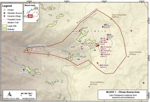
Figure 6-67. Block 1 Late Prehispanic features.
Pastoral activities
Grazing activities appear to have persisted during the Late Prehispanic in Block 1 as they did during the Early Agropastoralist period. Low densities of non-diagnostic sherds from utilitarian wares are found in association with colonial and modern sherds near the estancia in Maymeja A03-570. Pottery is otherwise relatively scarce in the Maymeja area. It is notable that no diagnostic MH, LIP, or LH sherds were found in association with the estancia at A03-570, or at other pastoral occupations in Maymeja, except for the A03-126 workshop area. One can also expect the later occupants of Maymeja to have continued to make use of the "Camino Hornillo" [A03-268] route leading to the quarry pit from the Escalera thoroughfare. However, if Late Prehispanic peoples did make use of this route, they left virtually no ceramics associated with it that would indicate that the quarry pit road was a regularly used feature.
A03-275 "Maymeja 5"
Just southwest of the area of the obsidian workshop, on the south perimeter of Maymeja, an extensive construction area (1 Ha) was encountered on the rocky slope along the edge of the bofedal that was generally terraced although heavily eroded. This area is shown in more detail on the map in Figure 6-54.
Figure 6-68. Three levels of terracing in [A03-275] below glacier polished rhyolite flow. Yellow tape shows 1m.
The construction along the margins of the bofedal was curiously devoid of ceramics, as were the other terraces immediately adjacent to the A03-126 Maymeja workshop. A light scatter of obsidian flakes is found throughout the terraced area, however, and obsidian flakes are concentrated along the base of the slope although these concentrations probably reflect downslope movement of artifacts. In this sector, on the south-west edge of the bofedal, several Late Horizon "Collagua-Inka" plates were encountered, and it is possible that this entire sector was constructed at a later time. The corner of a structure with a possible niche that appears to be built using the Inka-influenced cut-stone masonry technique was found 70m southwest of the obsidian workshop [A03-126] inside the larger terraced site area [A03-275]. Unfortunately, the remaining sides of this structure are too eroded to permit an estimate of the structure size, or to discern if it was a residential or mortuary construction. A pattern discussed by Wernke (2003) in the Colca valley was for circular residential structures to be dominant among pastoral settlements above 3900m. Given this architectural pattern, the structure at A03-339 is perhaps a square chulparather than a residential structure.
Figure 6-69. (a) Cutstone masonry [A03-339] from site A03-275 close to the workshop area at the Chivay obsidian source. Yellow tape shows 50cm. (b) Rim sherds from an 18cm diameter Inka-Collagua plate were found adjacent to this corner.
The presence of diagnostic Late Horizon materials in the obsidian source area was somewhat unexpected because during the Late Horizon the regional distribution of Chivay obsidian was relatively restricted in comparison with any time period since the Terminal Archaic. It is possible that the Late Horizon occupation in this area, particularly the painted plates, result from ritual functions associated with the abundant spring that irrigates the bofedal in the southern of Maymeja area, and that spring emerges very close to this location. However, if the structure [A03-339] is a looted Late Horizon chulpa, then the plate could have been one of the grave goods.
A03-240 "Molinos 1"
The only local Middle Horizon evidence from Block 1 close to the Chivay source comes from a pastoral area part of the way up the Quebrada de los Molinos climbing up from Chivay, 350 vertical meters above the town. This site is found adjacent to several large breccia boulders near a bofedal where the trail climbing from Chivay levels out after a steep pitch. A partially eroded rim sherd [A03-242.1] was found here that is diagnostic to the local Middle Horizon style. The sherd is made of burnished brown paste and with traces of paint on the rim, but the rim was too small to take a measure of the vessel diameter.
Mortuary features
Several chulpaswere identified in the Maymeja portion of Block 1, the locations of these features is shown on Figure 6-67.
A03-215 "Saylluta 1" appears to be a relatively large chulpa(2m in diameter). A mortuary function for this structure is suggested by the doorway which is only 70 cm high. No diagnostic materials were found. The base of a square structure was located just to the east that is possibly an old corral or a shelter, but it appears to be too large to be a roofed space.
A03-274 is a small crevice west of A03-201 with remnants of a wall inside and several small bones that appear to have been animal bones. A diagnostic Inka rim sherd of non-local design [A03-274.1] was found here.
A03-578 is circular chulpamade with double-walled construction, but without mortar. The chulpameasures approximately 2m in diameter. A site consisting of a light scatter of obsidian [A03-575] surrounds the chulpaand extends out onto a large promontory overlooking the Quebrada de los Molinos and the access to Maymeja from the trail climbing up from Chivay. There was also a medium density lithic locus here [A03-576] consisting primarily of flakes in tertiary stages of reduction (0-50% dorsal cortex). This site conforms to the pattern of lithic reduction atop the bluff on the western edge of Maymeja with very high observation potential. Visibility/exposure at this site is 39 by the visibility index, while the mean for sites in Block 1 is 18.5. This high visibility reduction pattern is discussed in Section 8.3.3.
In addition, the corner of the eroded structure at A03-339, described above, is perhaps a LH square chulpa(Figure 6-69).
Possible Late Prehispanic canal route
As agricultural intensification and terrace construction accelerated during Late Prehispanic times, the volume of water entering canal systems from the high altitude headwaters would have become increasingly important to the farmers below. The Huarancante canal system that irrigates the southern half of the Colca valley has been discussed in more detail elsewhere (Brooks 1998: 203-213;Wernke 2003: 235-246). This canal irrigates some of the most productive farm land in the main Colca valley, including the area around Yanque, the dominant community during the LIP and LH. Any additional water contributed into the Huarancante canal system would have been of great utility downstream.
While no glaciers are found in the Maymeja area and the precise date of deglaciation of Cerro Ancachita and Hornillo are not known, the spring that irrigates the southern half of Maymeja has a relatively high volume of flow. This flow is particularly notable in this porous volcanic landscape, where much of the surface water disappears underground. The substantial volume of water that descends from here to Chivay was sufficient to justify the construction of a mill during colonial times (the apparent namesake of Quebrada de los Molinos). Today, this water powers a small hydroelectricity plant for Chivay.
According to Sr. Mamami (2005, pers. comm.), the owner of "Tambo", a rich estancia between Chivay and Cerro Hornillo, a canal existed that connected Maymeja with Huarancante in the past and it traversed high above eastern edge of his land. Upon further discussion with S. Wernke (2005, pers. comm.), the significance of a possible extension to the modern Huarancante canal is explored here, as this extension would have been an important asset had it connected the abundant perennial spring in Maymeja to the Huarancante canal.
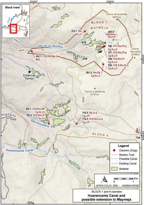
A possible route using contours derived from the ASTER 30m topographic DEM layer is presented here. Following Brooks' (1998: 203) estimate of 1° or less downslope for the canal, the canal is extended up from the point at which the existing canal departs from Quebrada Huanta Occo at 4745 masl on the north slopes of Nevado Huarancante. The contour distance to the Maymeja bofedal is approximately 10.5 km, which, at a 1° slope, would require a vertical change of 183m, indicating that the canal would have had to begin at around 4928 masl. The altitude of the Maymeja workshop in site A03-126 is 4902m, therefore when extrapolated over more than 10km the gradient potential exists for such a canal, but it would have required losing very little altitude across difficult terrain. No specific cliff bands block the construction of such a canal, but a steep lava cliff passes immediately above the canal route and the slopes below this loose cliff consist of an incline of sand and talus at approximately 45°. These features would have presented a difficult obstacle to canal construction.
Under Inka rule, the Collagua extended their agricultural production through projects such as canal expansion, and the construction of such a canal would serve to explain, in part, the predominance of Late Horizon Collagua-Inka ceramics over LIP Collagua ceramics in the Maymeja area. Unfortunately, due to fieldwork time constraints, the Upper Colca survey project was not been able to conduct a pedestrian survey along this potential canal route. The route contours around an extremely high colluvation zone below the lava outcrops of Cerro Llalluhue, and a canal in this area would have required significant maintenance.
The possible canal route shown on Figure 6-67 and Figure 6-70 is 11 km long and drops from 4905 to 4745 masl at a gradient of 0.83°. No features definitively related to canal construction were observed, but further fieldwork could confirm Sr. Mamani's account. Another possibility is that the Inka-Collagua presence in the Maymeja area results from a work-in-progress where feasibility study measurements and initial work were perhaps underway for the construction such a canal in the 16thcentury when the Spanish arrived. A scenario such as this would have left somewhat ambiguous evidence in the Maymeja area.
Figure 6-70. Blocks 1 and 4 overview showing possible route of Late Prehispanic canal.
Block 4 and 5 Reconnaissance Area
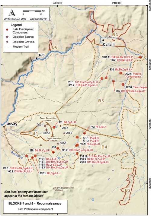
During the Middle Horizon, LIP and Late Horizon in the high altitude reconnaissance area near the Chivay source, several clusters of sites were observed that testify to the variety of lands used by pastoralists in this period. During the 2003 survey non-local Inka ceramics were encountered even in small, distributed pastoral sites, a higher frequency of use of obsidian with heterogeneities (Ob2), and a spatially distributed occupation pattern. These distributions perhaps reflect the growing herd sizes in the Collagua domain during the Late Prehispanic, and the need to exploit the resources in the puna as they become seasonally available.

Figure 6-71. Blocks 4 and 5 Reconnaissance - Late Prehispanic component.
An example of this distributed occupation pattern was apparent in the arid area on the south-east flanks Cerro Hornillo. Surveying across this arid area, the 2003 survey team encountered a settlement close to two ponds A03-738 "Lecceta 1" consisting of two small rock shelters and open air sites containing LIP and LH ceramics. The site includes a light scatter of obsidian flakes over the larger region, and two sectors with medium and high density obsidian scatters. The interesting thing about this site is the high incidence of use of Ob2 obsidian.
Between 500m and 1000m north of this settlement surveyors encountered surface obsidian lag gravels eroding from the base of the south-east flank of Hornillo in a formation that appears to represent a secondary obsidian quarry area. In fact, on further investigation of the source materials, it was noted that much of the obsidian on this side of Hornillo had heterogeneities (Ob2) consisting of <1 mm air bubbles trapped in the glass, as well as what appear to be ash particles. The nodules in this area were as large as 15cm long, but the typical large nodule for the area was only < 8 cm on a side. It seemed like the larger nodules had more Ob2 heterogeneities, as if perhaps there had been a preferential collection of large Ob1 nodules from this area.
The site of Lecceta 1 [A03-738] had unusually high levels of use of Ob2 obsidian. The Ob2 material was being knapped more extensively than anywhere else in the survey area.
|
Form |
Ob1 - homogeneous |
Ob2 - heterogeneous |
||||||
|
At site A03-738 |
Project surface collection |
At site A03-738 |
Project surface collection |
|||||
|
Tools |
2 |
100.0 |
290 |
92.7 |
- |
- |
23 |
7.3 |
|
Cores |
17 |
70.8 |
201 |
84.5 |
7 |
29.2 |
37 |
15.5 |
|
Flakes |
17 |
60.7 |
201 |
84.5 |
11 |
39.3 |
101 |
21.4 |
|
Total |
36 |
66.7 |
861 |
84.2 |
18 |
33.3 |
161 |
15.8 |
Table 6-55. Ob1 and Ob2 obsidian use at A03-738 "Lecceta 1" compared with entire project.
While there were more Ob1 cores, flakes, and tools collected at A03-738, there was a fair amount of reduction was occurring on the Ob2 material that was available near this camp. In particular, Ob2 cores and flakes are used at a much higher percentage in this site on than on average for the project on the whole. Given the Late Horizon evidence from this site, these data could be interpreted as supporting the notion that during the Late Prehispanic the acquisition of "high quality" obsidian, represented by Ob1 material, was deprioritized because obsidian was primarily used for the basic pastoral functions of butchering and shearing.


