6.5.3. Block 3 - Callalli
In the Block 3 area, in the upper Colca valley, a significant increase in population and land use intensity is apparent from the distribution of settlement, mortuary features, and fortifications encountered in this region.
Block 6
Block 6 is located along the Challacone drainage just upstream from the town of Tuti, on the western edge of the study area. A map showing this survey block appeared in Figure 6-42. In addition to an interesting Archaic component, this area contained local MH, LIP, and local LH ceramics. Furthermore, the bases for five chulpaswere encountered along the ridgetop just east of Quebrada Challacone.
Discussion
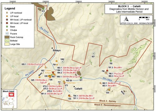
The evidence from the Late Prehispanic occupation of Block 3 suggests that a significant population increase occurred during this time in the upper Colca valley. The evidence from the Tiwanaku period and the Middle Horizon appear to show small settlements with an economy focused primarily on pastoralism. Despite the wide circulation of Chivay obsidian during this period, there is no evidence in Block 3 of outside contact during the Middle Horizon except for the Wari influence in the local Middle Horizon ceramic technology, as described by Malpass and de la Vera Cruz (1986) and by Wernke (2003). During the Late Intermediate Period, dramatic changes are notable in a variety of forms of archaeological evidence in a pattern that is consistent with that observed by Wernke in the main Colca valley. Some limited agricultural cultivation appears to have been practiced given the association of LIP ceramics with cultivated areas. Pukara construction and some types of chulpaburial monuments are further evidence of LIP period occupation.
Late Horizon
In the Block 3 area the Late Horizon appears to involve the settlement of larger communities along the wide terrace margins of the Río Llapa. Sites associated with cultivated areas that had a slight Middle Horizon component and a stronger LIP component, appear to be the most extensively occupied under Inka dominance in the Late Horizon. The LH pattern of large settlements adjacent to agricultural lands is consistent with the pattern observed elsewhere in the highlands of southern Peru. In the Lake Titicaca Basin, Stanish notes that the settlement hierarchy for sites under 2.5 Ha remained mostly unchanged with the onset of the LH, but under Inka rule new large administrative sites were founded (Stanish 2003: 253-258). In the main Colca valley, Wernke (2003: 217-224,439-441) concludes that Inka administrative strategy involved ruling through local elites using the pre-existing ayllustructure of community organization. The effect on the settlement system was to promote a single administrative center, Yanque, to the top of the settlement hierarchy and other LIP sites became second-tier centers.
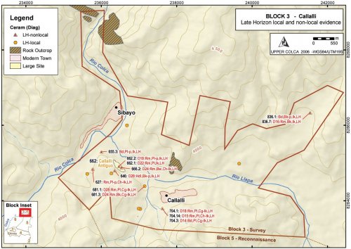
In the Callalli area, Late Horizon diagnostic ceramics were appear to have been concentrated along the south margin of the confluence area, known as Callalli Antiguo, and a small concentration of Late Horizon materials were found on the south-western edge of modern Callalli. The town of Sibayo, on the north side of the river confluence, was outside of the 2003 survey boundary, but it is possible that a Late Horizon settlement exists in that area as it complements Callalli Antiguo on the south. It is worth nothing that a principal prehispanic road along the Upper Colca valley lay on the south bank of the river where the route passes through to Canocota en route to Chivay. This road appears to have passed by the confluence area in the vicinity of Callalli Antiguo and as a major thoroughfare it is an appropriate place to position an administrative center.
Figure 6-80. Block 3 Late Horizon diagnostic materials
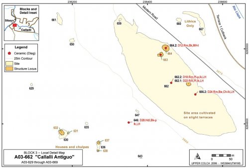
To the west of Callalli the 2003 survey encountered a settlement that is known locally as "Callalli Antiguo" (F. Windischhofer 2003, pers. comm.). The site sprawls over the natural terraces just south of the confluence of the Colca with the Llapa, across from Sibayo. An extensive part of the site is located adjacent to the main road, while a cluster of collapsed structures, including houses and chulpas, are located just on the southern side of a ridge that divides the site in half. One might expect to find an Inka administrative site in this area. If this were an administrative site, however, it would also be fitting to encounter a number of well-constructed structures with Inka features, such as trapezoidal doors and cut-stone masonry as observed by Wernke (2003) at a number of sites in the main Colca Valley
Figure 6-81. Callalli Antiguo [A03-662] and surroundings.
Figure 6-82. A03-662 north sector of Callalli Antiguo agricultural sector, with two individuals walking together in the center of the photo providing scale and the Río Llapa and the town of Callalli in the background.
Vestiges of terraces are apparent in this larger, 4.2 hectare cultivated area of A03-662, and the sector appears to have been in agricultural production at one time where it is may have been involved in dry land production of high altitude seed-plants Chenopodium. Old natural terraces of the Río Llapa, slight terraces visible in the site overview photo below (Figure 6-82), were plowed and planted using field boundaries that follow terrace edges accentuated by the rocks that were thrown along the margins during field clearing. Some suggestion of eroded canal features were evident as well, implying that some form of irrigation was achieved, although such irrigation would likely have required diverting water from Quebrada Taukamayo to the east (adjacent to A02-26, see Figure 6-62)
Middle Horizon and Late Intermediate Period
As has been discussed above, the role of regional states in the Colca valley during the Middle Horizon is somewhat enigmatic. Wari influences are apparent in architecture and ceramic attributes, but direct evidence of Wari control has not been encountered. No evidence of Tiwanaku, a principal consumer of Chivay obsidian, has been encountered in the region. The local Middle Horizon ceramic type defined by Wernke (2003) was encountered in low densities in Block 3, although generally in spatial association with LIP sherds suggesting a continuity of economic and settlement patterns.
During the Late Intermediate Period there appears to have been a significant increase in population in the Block 3 region. The founding myth of the Collagua people, as recorded by a Spanish ethnohistoric source, has them conquering the Colca valley upon their descent from the Mount Collaguata near Velille in Espinar (Cusco) 120 km north of this region (Ulloa Mogollón 1965 [1586]; cited in Wernke 2003: 80). Data is not available from this surface survey to test the alleged population replacement, but some continuity in land use pattern is apparent from the occupation of areas with both local Middle Horizon ceramics and LIP ceramics.
One site that shows ceramics from throughout the sequence that includes the possible Formative Period (Chiquero), the Middle Horizon, LIP, and Late Horizon, is the site of Taukamayo [A02-26] discussed in more detail in Early Agropastoral section (seeFigure 6-60). This site has been partially destroyed by a creeping landslide that has resulted in shuffling of stratigraphy within the displaced slump deposit and the exposure of a variety of artifacts from the prehistoric sequence. In the creep debris there are concentrations of stone associated with LIP and LH ceramics that suggest that chulpas, perhaps similar to the one observed at a site immediately to the north [A03-673], were built along the terrace that has since collapsed in the creep.
 Figure6-78. Block 3 Middle Horizon and Late Intermediate Period features.
Distinctive features from the LIP include a number of shared features from the Titicaca Basin mentioned previously. These consist of pukaras, chulpasand distinctive types of cave burials. Pukaras are fortified hilltops settlements usually occupied only for short-term, defensive purposes (Arkush 2005;Stanish 2003: 209-218;Wernke 2003: 251-265).
Agricultural production
While agriculture is very limited in the modern economy of the Callalli area, evidence of relatively extensive past agriculture is apparent along the Terrace 1 and 2 margins of the Río Llapa. In the vicinity of A03-785 and A03-797 on the east side of Block 3, extensive areas of previously furrowed agricultural lands are evident. Artifact associations with these agricultural lands primarily belong to the Late Intermediate Period and Late Horizon, but the remains of a colonial site near A03-785 is apparent as well.
Structures
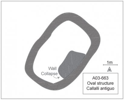
On the north side by the road an agricultural sector was encountered with a half-dozen collapsed rock structures including three structures of rounded rectangular form that may have been domestic. These three structures have walls that were constructed using a double coursed design with mortar, and the walls tilt slightly inward. Wernke (2003: 197-199) describes circular houses as being common for pastoral peoples in the higher altitude portions of the Colca valley beginning at the site Laiqa Laiqa near Tuti around 3900 masl. Rounded-rectangular structures are therefore unusual at this altitude in the valley. The double coursed walls of A03-663 measured approximately 90cm in thickness. Other possible explanations for these structures are that they served as storage silos (although the Late Horizon Qolqa storage silos are not found in the Colca valley), or these buildings could have been large burial towers. The ceramics collected in the immediate vicinity of these buildings span the Late Prehispanic with a single local Middle Horizon sherd, several LIP Collagua sherds, and Collagua-Inka LH sherds.
|
Figure 6-83. Base of walls of structure |
Figure 6-84. Collapsed wall of A03-663 structure. |
Ceramics
Surface collections of pottery from the area of Callalli Antiguo reveal that the site is a multicomponent occupation, but that the area appears to have been primarily a Late Horizon settlement. No brushed, unslipped pottery similar to the Chiquero Formative described by Wernke (2003) for the main Colca valley was found in this area.
|
Period |
Style |
Beaker |
Bowl |
Pitcher/Jar |
Plate |
Unknown |
Total |
|
LH |
Chucuito-Inka |
1 |
1 |
||||
|
LH |
Inka |
1 |
2 |
3 |
|||
|
LH |
Collagua-3 |
2 |
2 |
4 |
|||
|
LH |
Collagua-Inka |
1 |
1 |
||||
|
LIP-LH |
Collagua |
1 |
1 |
1 |
3 |
||
|
LIP |
Collagua-2 |
3 |
3 |
||||
|
MH |
Local MH |
1 |
1 |
Table 6-57. Diagnostic ceramics from Callalli Antiguo [A03-662] and vicinity.
The ceramics data suggest that this area, which does not have a pukara adjacent to it, was settled following the Inka conquest in the Late Horizon.
Lithics
A relatively large percentage of obsidian cores were observed at this site, particularly in the southern sector by the houses and chulpasshown on Figure 6-79. It is notable that one half of the fifteen Ob1 cores found in Block 3 were found here, and they are relatively large cores for Block 3.
|
Callalli Antiguo Cores |
Block 3 Surface Collection |
|||||||
|
Material |
No. |
m % Cortex |
mWt |
sWt |
No. |
m % Cortex |
mWt |
sWt |
|
Obsidian |
7 |
10 |
35.9 |
6.82 |
17 |
5.0 |
23.2 |
13.1 |
|
Volcanics |
1 |
20 |
117.8 |
- |
2 |
7.5 |
87.7 |
42.6 |
|
Chalcedony |
1 |
20 |
27.1 |
- |
4 |
16.7 |
47.5 |
18.1 |
|
Chert |
3 |
42.1 |
61.6 |
32.3 |
18 |
32.1 |
57.17 |
33.8 |
|
Total |
12 |
32.1 |
48.4 |
29.0 |
41 |
21.6 |
43.6 |
31.3 |
Figure 6-85. Cores at Callalli Antiguo [A03-662] and vicinity compared with all of Block 3.
It appears that obsidian cores were being transported here from the Maymeja area disproportionately to the rest of Block 3. The other site with a large number of Ob1 obsidian cores (n=6) is Taukamayo [A02-26] that was tested with the A02-26u1 unit and the u2 profile.
Mortuary features
Chulpaburial towers (Stanish 2003: 229-234;Wernke 2003: 225-233) are found throughout the Block 3 area on promontories and sometimes in caves or niches in cliff faces. Chulpaswere constructed during the LIP and LH in this region, while cist tombs are known to date from the preceding Middle Horizon. Few Block 3 chulpasare standing, and many of the stones appear to have been reused in nearby modern field walls. Cave burials were also encountered where the interments were "cocoon bundle" burials (de la Vega, et al. 2005;Wernke 2003: 233-234); this kind of interment was evident in the partially looted cave burial of A03-815 on the north end of the Block 3 survey area.
|
Figure 6-79. Recently looted cocoon-type interment from A03-815. |
Pukaras
A number of pukaras were encountered in the Block 3 area survey. Several of these [A03-607 and A03-796] include only small construction efforts on single walls, while a few pukaras had two or three defensive walls and structures on top, such as A03-1082. The most extensive evidence of pukara construction in Block 3 comes from A03-935, a large pukara on top of the lower sector of the Castillos de Callalli (the lower formation is also known as Cabeza de Leon) with natural escarpments over 50m high that were supplemented by four rows of walls on various areas of the hill. Three rows of walls were also encountered blocking access via the gullies close to Quelkata cave. This pukara represents a large, defensible zone.
Another relatively large pukara, Condorquiña [A02-6] was encountered in 2002 just over 5 km south along the west side of the Pulpera drainage (shown in Figure 6-69). Pukara Condorquiña has three major rows of walls and the remains of 10 oval structures on the summit the majority of them measuring about 1.8 x 2.3 m across.


