Late Horizon
In the Block 3 area the Late Horizon appears to involve the settlement of larger communities along the wide terrace margins of the Río Llapa. Sites associated with cultivated areas that had a slight Middle Horizon component and a stronger LIP component, appear to be the most extensively occupied under Inka dominance in the Late Horizon. The LH pattern of large settlements adjacent to agricultural lands is consistent with the pattern observed elsewhere in the highlands of southern Peru. In the Lake Titicaca Basin, Stanish notes that the settlement hierarchy for sites under 2.5 Ha remained mostly unchanged with the onset of the LH, but under Inka rule new large administrative sites were founded (Stanish 2003: 253-258). In the main Colca valley, Wernke (2003: 217-224,439-441) concludes that Inka administrative strategy involved ruling through local elites using the pre-existing ayllustructure of community organization. The effect on the settlement system was to promote a single administrative center, Yanque, to the top of the settlement hierarchy and other LIP sites became second-tier centers.
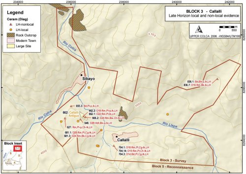
In the Callalli area, Late Horizon diagnostic ceramics were appear to have been concentrated along the south margin of the confluence area, known as Callalli Antiguo, and a small concentration of Late Horizon materials were found on the south-western edge of modern Callalli. The town of Sibayo, on the north side of the river confluence, was outside of the 2003 survey boundary, but it is possible that a Late Horizon settlement exists in that area as it complements Callalli Antiguo on the south. It is worth nothing that a principal prehispanic road along the Upper Colca valley lay on the south bank of the river where the route passes through to Canocota en route to Chivay. This road appears to have passed by the confluence area in the vicinity of Callalli Antiguo and as a major thoroughfare it is an appropriate place to position an administrative center.
Figure 6-80. Block 3 Late Horizon diagnostic materials
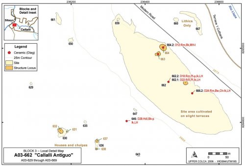
To the west of Callalli the 2003 survey encountered a settlement that is known locally as "Callalli Antiguo" (F. Windischhofer 2003, pers. comm.). The site sprawls over the natural terraces just south of the confluence of the Colca with the Llapa, across from Sibayo. An extensive part of the site is located adjacent to the main road, while a cluster of collapsed structures, including houses and chulpas, are located just on the southern side of a ridge that divides the site in half. One might expect to find an Inka administrative site in this area. If this were an administrative site, however, it would also be fitting to encounter a number of well-constructed structures with Inka features, such as trapezoidal doors and cut-stone masonry as observed by Wernke (2003) at a number of sites in the main Colca Valley
Figure 6-81. Callalli Antiguo [A03-662] and surroundings.
Figure 6-82. A03-662 north sector of Callalli Antiguo agricultural sector, with two individuals walking together in the center of the photo providing scale and the Río Llapa and the town of Callalli in the background.
Vestiges of terraces are apparent in this larger, 4.2 hectare cultivated area of A03-662, and the sector appears to have been in agricultural production at one time where it is may have been involved in dry land production of high altitude seed-plants Chenopodium. Old natural terraces of the Río Llapa, slight terraces visible in the site overview photo below (Figure 6-82), were plowed and planted using field boundaries that follow terrace edges accentuated by the rocks that were thrown along the margins during field clearing. Some suggestion of eroded canal features were evident as well, implying that some form of irrigation was achieved, although such irrigation would likely have required diverting water from Quebrada Taukamayo to the east (adjacent to A02-26, see Figure 6-62)


