7.4.1. Q02-2, Test Unit 2
The broader context of Q02-2 and a map of the quarry pit vicinity are shown in the Early Pastoralists section of Chapter 6 (see Figure 6-45). Few concentrations of cultural artifacts were found on the surface of the quarry pit that would have aided in selecting a location for the 1x1m test unit. There was a great quantity of fractured obsidian, but as will be described below, the test excavation showed that geologically fractured obsidian was the rule and culturally produced flakes were rare in this area. Lag gravels consisting of small, 1-5cm obsidian nodules were observed in a very light tephra-rich soil that formed the context of the quarry pit. The area had little evidence of cultural activity except the excavated pit itself, the associated debris pile, and the greater concentration of dozens of 5-15cm nodules in the bottom of the quarry pit.
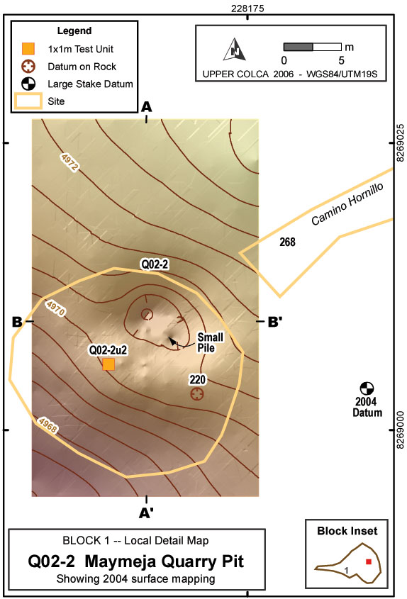
Figure 7-4Map of quarry pit showing topographic surface acquired using a total station.
Figure 7-5. (a) Perspective view of quarry pit, (b) Perspective view bisected with an inferred natural slope.
The Q02-2 pit is a depression that measures approximately 4m by 5m, with a depth of 1.5m despite evidence that this pit, excavated into sandy soils, has collapsed margins and has been partially refilled over the years (Figure 7-4). If the area that deviates from the natural slope, including the accumulation pile downslope, is included the disturbed area grows to measure 10m by 12m. Oblong quarry pits ringed by semi-circular debris piles are described at obsidian sources in central Mexico by Healan (1997) and by Darras (1999: 80-84), although this quarry pit falls in the medium size range by Mexican standards.
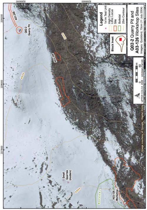
Figure 7-6. The quarry [Q02-2] and workshop [A03-126] are 600m apart. In this image snow blankets most south-facing slopes but the quarry pit debris pile is visible protruding through the snow mantle.
The deepest part of the Maymeja quarry pit at Chivay tends to retain snow (see photo in Figure 6-45), and in the southern half of the quarry depression it was evident that more recent disturbance had occurred. A small mound of light, sandy soil and many small nodules of obsidian are labeled as "small pile" in Figure 7-4. This small mound measures 1m by 1.5m and is 30cm in height. This small pile appears to be the result of recent excavation work and perhaps resulted in the exposure of the 5-15cm nodules currently visible in the pit.
History of study of quarry pit Q02-2
During a preliminary visit in 2002, I climbed to the Maymeja area using the description and GPS-derived UTM coordinates provided in Burger et al. (1998:205) where I spoke with a herder named Mattias Sarallasi who was working for the land owner from Callalli, Eliseo Vilcahuaman Pambra, and living in the estancia at the base of Maymeja. Sarallasi grabbed a shovel and led me up across the moraines past several small and shallow (1-2m diameter) quarry holes that he indicated to me, and finally to the Q02-2 quarry pit.
In Burger, et al. (1998:204) the authors write that in their 1995 visit Burger and Salas "encountered a local farmer who had been collecting quantities of obsidian from these deposits for future sale." Further, they note that "according to a local farmer, a German resident of Bolivia had visited this obsidian deposit in order to collect obsidian for export to La Paz where it was transformed into craft products". An initial concern for the Upper Colca Project was establishing that the extant pit was not the result of this modern quarrying in the Maymeja area. Directly datable materials were not located in the 2003 research to confirm the antiquity of the pit, but the integrity of the stratigraphy in the test unit, and the presence of cores and bifaces in the excavation, strongly suggest that the quarry pit feature is not a recent excavation. The conclusion here, based on the soil characteristics and the small quarry pits along the ridges below Q02-2, is that recent quarrying work was responsible for the small pile of light soil inside the q02-2 quarry, and for the small quarry pits downslope. The small pile encountered inside the quarry pit feature resembles the level 2 soil encountered in the test unit, suggesting that this modern quarrying entered at least as far as the stratum that was found 15cm below the surface in the 1x1m test unit.
The regional context of this quarry pit, including the relationship between the quarry pit, a Precolumbian road leading to the quarry, and other archaeological features, are described in Section 6.4.1. A discussion of the quarrying methods that may have been used at this location can be found in Ch..
Testing in the debris pile in 2003
In the course of the 2003 Upper Colca Project a 1x1m test unit was placed at Q02-2 in the debris pile immediately downslope of the quarry pit. The unit was aligned to true north and placed on the uphill side of the summit of the debris pile with the aim of bisecting the widest range sizes of pre-existing debris piles as the pile had accumulated below the quarry during ancient use. In the course of the test excavation, the team avoided filling the quarry pit feature with soil or other materials and instead positioned the backdirt piles and screened dirt on the south-east end of the quarry feature.
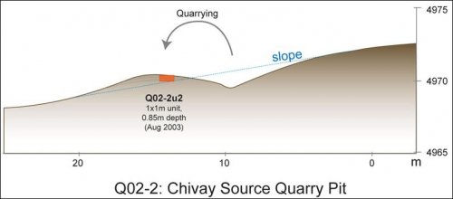
Figure 7-7. Diagram of Q02-2 quarry pit and position of the Q02-2u2 test unit relative to quarry debris layers and natural slope. By virtue of the quarrying history, levels are inverted in the 1x1m test unit so upper levels came from lower (earlier) levels in the quarry pit.
The quarry pit debris pile included relatively few culturally modified artifacts. While thousands of obsidian "flakes" with conchoidal fracture were encountered, closer inspection revealed that a very small minority were fractured by the human hand. Cortex is sometimes very thin on many of the flakes and nodules at the Chivay source (Section 4.5.1), which complicated the task of differentiating cultural and non-cultural flakes. Non-cultural flakes had no clear bulb or striking platform, or the geometry of the bulb was such that the force responsible for fracturing the rock was evidently far away and was geological in scale. In other words, one would see bulbs of percussion that appeared to have been initiated on adjacent rocks by geological or environmental processes, and the force of the fracture transferred through the obsidian matrix.
Figure 7-8. Q02-2, view of quarry pit and u2 test unit from the north.
Characteristics by level
While the test unit did not expose diagnostic artifacts or datable material, such as carbon, that would have facilitated identifying the culture group associated with the quarrying, it revealed changes in stratigraphy and material that contribute to understanding the prehistory of the Chivay source. Provisional estimates, based on comparisons with dates from the adjacent workshop test unit Q02-2u3, suggest that the bulk of quarrying at Q02-2u2 occurred in the Early Formative. It should be stressed here that because the test excavation is into a debris pile in Q02-2u2, levels are invertedso higher levels in the test unit came from lower in the Q02-2 quarry pit.
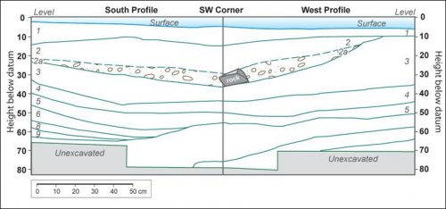
Figure 7-9. Q02-2u2 quarry pit south and west profile diagrams showing excavation levels.
Figure 7-10. South profile of Q02-2u2 at quarry pit at the top of levels 11/12.
The test unit Q02-2u2 stratigraphy indicates that episodic filling events occurred in this location. In the profile figure, excavation levels are represented approximately as indicated by strata lines. The profile photo (Figure 7-10) shows the south profile wall, therefore the quarry pit is located off of the left side of the photo frame. As expected, the stratigraphy generally slopes downwards towards the right. However, in level 2 and to a lesser extent in level 3 the stratigraphy levels out and even rises slightly, indicating there was major deposition on the quarry debris pile. These profiles suggest that the quarrying took place in two major episodes with what appears to have been some minor quarrying activity before and after each larger episode. The soil characteristics and artifact evidence provides more insights in to the circumstances surrounding the quarrying.
|
Level |
HBD* |
Comments / Interpret. |
Soil |
Photos #s |
|
1 |
5 |
Pale brown 10YR6/3, Sand, Fine grain, Poorly sorted, .5/.1 |
2010 |
|
|
2 |
15 |
Intensive quarrying |
Very pale orange 10YR8/2, Sand, Med grain, Poorly sorted, .7/.5 |
2014 |
|
2a |
21 |
Obsidian nodules ~7cm |
Concentration of larger nodules in v. light sandy soil. |
|
|
3 |
24 |
Intensive quarrying |
Light brownish grey 10YR6/2, Sand, Coarse grain, poorly sorted, .5/.5 |
2025 |
|
4 |
35.5 |
Pale brown 10YR6/3, Sandy loam, Fine grain, Poorly sorted, .5/.3.Ave grain size: .25, subangular to rounded. |
2026-2028 |
|
|
5 |
46.5 |
Very pale brown 10YR7/3, Sand, Fine grain, Poorly sorted, .5/.3.Ave grain size: .25, subangular to rounded. |
2029-2030 |
|
|
6 |
56 |
Increased moisture in soil, reduced frequency of larger obsidian pieces. |
Pale brown 10YR6/3,Sand, Med. grain, Poorly sorted, .7/.3.Ave grain size: .25-.5mm, subrounded. |
2030 |
|
7 |
59 |
Less obsidian, greater moisture. |
Pale brown 10YR6/3, Sand, Med. grain, Poorly sorted, .7/.3.Ave grain size: .5mm, subrounded. |
2031 |
|
8 |
66 |
Greater compaction, less rocky. Possibly entering natural slope. Small: .5-1mm, Med: 1-2mm |
Light yellowish brown 10YR6/5, Sand, Med. grain, Poorly sorted, .7/.3 |
2033-2036 |
|
9 |
69 |
Pale brown 10YR6/3, Sand, Coarse grain, Poorly sorted, .7/.7 |
2084-2085 |
|
|
10 |
72 |
Pale brown 10YR6/3, Sand, Coarse grain, Poorly sorted, .7/.7 |
2086 |
|
|
11 |
74 |
Pale brown 10YR6/3, Sand, Coarse grain, Poorly sorted, .7/.3 |
2087 |
|
|
12 |
85 |
Light brownish grey 10YR6/2, Sand, Fine grain, Poorly sorted, .3/.5 |
2090-2091 |
|
|
* HBD = mean height below datum in centimeters for the top of each level based on five depth measurements. |
||||
Table 7-7. Q02-2u2 Excavation levels from test unit at quarry pit. Excavation photos available online.
|
Level |
Flakes |
Cores |
Biface |
Ret'd Flake |
Preform |
Total |
|
1 |
6 |
6 |
||||
|
2 |
16 |
16 |
||||
|
3 |
8 |
8 |
||||
|
4 |
11 |
1 |
12 |
|||
|
5 |
13 |
1 |
14 |
|||
|
6 |
1 |
1 |
2 |
|||
|
7 |
2 |
2 |
||||
|
8 |
6 |
6 |
||||
|
10 |
7 |
1 |
1 |
9 |
||
|
11 |
10 |
10 |
||||
|
Total |
80 |
2 |
1 |
1 |
1 |
85 |
Table 7-8. Q02-2u2 lithic technical class by test unit excavation level.
The vast majority of obsidian fragments at Q02-2 were non-cultural in origin. The artifact data show that culturally derived flakes were found as low as level 11, and cores and retouched items were found in level 10. These data suggest that the quarry pit area was being exploited for obsidian production with in-situ production before it was being excavated on the scale of the later pit. The distributed nature of the cores, flakes, and retouched artifacts in a stratigraphic profile that is predominantly made up of excavation debris, points to a general focus on procuring whole nodules from this location.
|
Level |
Ob1 |
Ob2 |
% Ob2 |
Clear-Banded |
Clear |
Grey-Banded |
Grey |
|
1 |
4 |
2 |
33.3 |
1 |
2 |
2 |
|
|
2 |
16 |
0.0 |
4 |
4 |
2 |
5 |
|
|
3 |
8 |
0.0 |
2 |
2 |
1 |
2 |
|
|
4 |
11 |
1 |
8.3 |
3 |
4 |
1 |
3 |
|
5 |
12 |
1 |
7.7 |
5 |
5 |
1 |
1 |
|
6 |
1 |
0.0 |
|||||
|
7 |
2 |
0.0 |
1 |
||||
|
8 |
4 |
2 |
33.3 |
2 |
4 |
||
|
9 |
0.0 |
||||||
|
10 |
9 |
0.0 |
1 |
5 |
2 |
||
|
11 |
10 |
0.0 |
3 |
4 |
2 |
1 |
|
|
Total |
77 |
6 |
7.2 |
19 |
27 |
9 |
20 |
Table 7-9. Q02-2u2 quarry pit obsidian artifact material type and color by level.
A principal question concerning the ancient excavation of the quarry pit is: why excavate for obsidian when it is available on the surface? What desirable characteristics of subsurface obsidian justify the effort expended in digging this quarry pit? Here, the consistency and visual qualities of the obsidian artifacts excavated from Q02-2u2 are examined in order to determine if there were patterns in those characteristics of the material. As shown in Table 7-9, Ob2 obsidian accounted for 7.2% of the artifacts analyzed from the test unit at Q02-2u2, which is comparable to the ratio of projectile point use in the project overall where just 7.8% of the obsidian projectile points observed in the course of 2003 fieldwork were produced on Ob2 obsidian.
|
Color of obsidian |
Artifacts from Q02-2u2 |
All Obsidian Projectile Points from 2003 Fieldwork |
||
|
Clear |
27 |
36.0% |
43 |
35.3% |
|
Clear_Banded |
19 |
25.3% |
23 |
18.9% |
|
Grey |
20 |
26.7% |
35 |
28.7% |
|
Grey-Banded |
9 |
12.0% |
21 |
17.2% |
|
Total |
75 |
100.0% |
122 |
100.0% |
Table 7-10. Q02-2u2 Color in quarry pit artifacts compared with all obsidian projectile points from fieldwork.
These data indicate that obsidian from the quarry pit had variability in color of material that was comparable to obsidian use over the entire region. In other words, quarrying individuals at the Q02-2 quarry in the past could expect a relatively low percentage of Ob2 material and color distributions that are consistent with the percentages used for tool production. However, as obsidian was acquired from a number of surface sources, the material quality and color of obsidian from the Q02-2 quarry pit does not appear to have been a principal motivation for excavating in that location. It appears that the quarry pit was relatively typical of the tool characteristics in the region.
However, a difference in cortical flake size from the quarry pit was noted.
|
Flake Length in mm |
|||||||
|
Level |
10 - 20 |
20 - 30 |
30 - 40 |
40 - 50 |
50 - 60 |
60 - 70 |
Total |
|
1 |
1 |
1 |
2 |
||||
|
2 |
1 |
2 |
1 |
3 |
7 |
||
|
3 |
1 |
1 |
2 |
||||
|
4 |
1 |
1 |
2 |
1 |
5 |
||
|
5 |
4 |
4 |
|||||
|
8 |
2 |
2 |
|||||
|
10 |
1 |
2 |
1 |
4 |
|||
|
11 |
1 |
1 |
2 |
||||
|
Total |
1 |
3 |
11 |
6 |
6 |
1 |
28 |
Table 7-11. Q02-2u2 quarry pit: Lengths of flakes and cores with >20% cortex.
Because production appears to have been largely conducted elsewhere, the counts for cortical flakes are relatively low. The pattern here suggests that larger nodules were available in deeper in the quarry. Again, levels are invertedin the test unit because the excavation is into a secondary debris pile (Figure 7-7), so higher levels in the 1x1m test unit came from lower levels in the original Q02-2 quarry. It appears that there was an abundance of large nodules and limited flaking was occurring later in the use of the quarry, and therefore larger flakes were being discarded. In a later discussion below, these data are compared with data presented in Table 7-26, from test unit Q02-2u3 at the A03-126 quarry workshop, in order to explore the connection between the quarry pit and the workshop.
A natural slope has been estimated from the surface map created using a total station in 2004 (Figure 7-7). Subtracting the surface map elevation from the calculated natural slope elevation at the location of the Q02-2u2 test unit allows for an estimate of depth at which one would encounter the sterile natural slope in the excavation unit.
|
Surface elevation |
- |
Natural slope |
= |
Depth of |
|
4980.10 |
- |
4979.27 |
= |
0.83 |
Table 7-12. Calculated depth of strata in Q02-2u2.
This independent calculation is confirmed by the Q02-2u2 excavation because sterile soil was encountered at approximately 85 cm depth. Based on the thin strata in the test unit profile, it appears that quarrying in this location was initially low-intensity, but that two episodes of large scale quarrying appear to have occurred in level 3, and especially level 2, of the strata profile which correspond to later episodesin the history of the quarry pit.


