7.5. Block 2 Test Excavations at Pausa A02-39
7.5.1. A02-39, Test Unit 1 and 2
The local context of A02-39 is described in Section 6.4.2 and Figure 6-58. Two test units were placed along the perimeter of two separate oval features [A03-557 and A03-559] on the southern portion of A02-39 "Pausa". The Test Units 1 and 2 were essentially sterile. In TU2 non-diagnostic bone and charcoal were found in an ash layer that appeared level to the built-up oval wall just to the east of TU2. Some carbon samples were retrieved from TU2 level 4 (33cm below datum) and the carbon returned a date of 1586BP±35 (AD 400-570), an Early Tiwanaku period date following Stanish's (2003) date of AD 400 for the onset of the Tiwanaku period. This would be an Early Intermediate Period date following the Ica chronology.
Discussion
Evidence from TU2 (A02-39u2] suggests that this secondary rock oval structure [A03-557] to the south-west of the main Pausa ovals, was perhaps an overflow area. As the test unit was placed at the bottom-most portion of the oval (presumably a corral structure) much of the bone and charcoal that was encountered was perhaps fill that was swept to the lowest point in the corral by animal activity. It appears that during the Early Tiwanaku period the enclosed area was relatively level and charcoal and bone were swept to the bottom of the corral area.
7.5.2. A02-39, Test Units 3 and 4
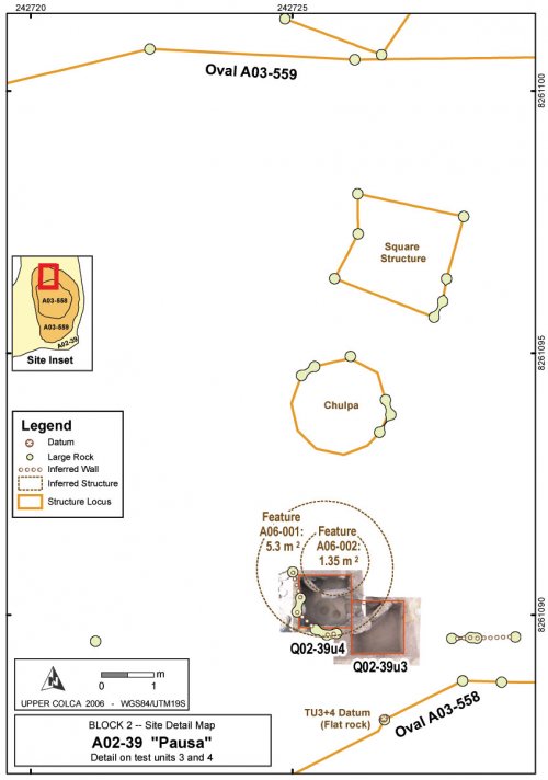
Test Units 3 and 4 are adjacent 1x1m test units placed immediately outside of the northern edge of structural features A03-558 (see Figure 6-58 and Figure 7-32) where a curved alignment of rock slabs appears to delimit a residential structure.
Figure 7-30. A02-39u3 (upper unit in photo) and u4 (lower) at basal levels. Top of photo is east.
Figure 7-31. Circular hearth (F1) in A02-39u4, level 5. Top of photo is north, unit is 1m on a side.

Figure 7-32. A02-39 "Pausa" - north, with Test Units 3 and 4, ovals, and inferred features. Compare with larger map showing ovals in Figure 6-58.
Excavations revealed that inside the curved wall feature [A06-001] was another wall consisting of two slab rocks [A06-002] floating above the depth of the six large rocks that make up A06-001. Circular features have been extrapolated from these two structures and they are shown in Figure 7-32. The circular inference of the smaller feature [A06-002] is more speculative, as only three large slab rocks were found and the rocks seem displaced.
Stratigraphy
The local test unit datum for both of these units was placed on a large, flat rock that is part of the A03-558 oval that lies just to the south of TU3. This mapping station, as well as the site datum north, are shown in Figure 7-32 in the positions where they were mapped with a total station in 2004.
|
Level |
H.B.D.* |
Contents |
Soil |
Photo # |
|
1 |
5 |
Top surface. Roots |
Fine sandy volcanic soil, roots from low brush |
2638 |
|
2 |
12.5 |
F1: NW of rocks, 0a: matrix. Roots |
V. Dk Grey/Brown 10YR3/2, fine grain, sub-angular,poorly sorted .7/.5 |
2641 |
|
3 |
17.5 |
F1, F2, 0a. Roots |
Dark brown 7.5YR4/2, subangular blocky, med grain, poorly sorted, .7/.3 |
2646 |
|
4 |
32 |
F1: midden, indoor? F3: light, sterile Roots, lithics, ceramics |
F1: V. Dk Grey/Brown 10YR3/2 Fine grain, subrounded, well-sorted, .9/.7; F3: Brown 7.5YR4/3, med grain, poorly sorted, .9/.5 |
2650-2651 |
|
5 |
44 |
F1 |
Dark brown 7.5YR4/2, subangular blocky, med grain, poorly sorted, .9/.5 |
2661-2663 |
|
6 |
56 |
F1a, F3 Lg chert flake lying flat, organic soil |
F1a: Dark brown 7.5YR3/2, med grain, well sorted, .9/.7; F3: Brown 7.5YR4/3, med grain, poorly sorted, .9/.3 |
2664, 3035-3414 |
|
* HBD = mean height below datum in centimeters for the top of each level based on five depth measurements. |
||||
Table 7-27. A02-39u3 test unit. Excavation levels, overview, and soil description.
|
Level |
H.B.D |
Contents |
Soil |
Photos |
|
1 |
3 |
S1: Top surface Rocky soil, obsidian and non-diagnostic ceramics |
Compacted, roots. |
2649 |
|
2 |
14 |
S2: F1: N side; F2: S side Rocks and roots, fewer artifacts |
F1: Dark brown 7.5YR3/2, silty sand,med grain, poorly sorted, .7/.5 |
2665 |
|
3 |
23 |
S3: F1, F2 Yellowish grey wall mortar. Black-on-red sherd in wall. |
Dark brown 7.5YR3/2, silty sand, subangular blocky, med grain, poorly sorted, .9/.3 |
2680 |
|
4 |
32 |
S3: F1, F2 Small charcoal pieces. Greyish brown poss. Midden.14C: 1822±37 bp |
F1: Alluvial, V. Dk Grey/Brown: 10YR3/2, silty sand, med grain, poorly-sorted,.9/.3. F2: Dk brown 7.5YR3/2, silt, subangular blocky, fine grain, poorly-sorted, .9/.3 |
3012 |
|
5 |
37 |
S4: F1,F2,F3 Less compact, carbon, ceramic, bone, charcoal, much obsidian. |
F1: V. Dk Grey 7.5YR4/1, subangular blocky, coarse, poorly sorted, .9/.7 |
3016 |
|
6 |
49 |
S5: F1,F2,F3 Less compact, carbon, ceramic, bone, charcoal.14C: 1698±31 bp |
Dark brown 7.5YR3/2, silty clay, subangular blocky, poorly sorted. F1: fine grain .9/.3, F2: coarse grain, .9/.3, F3: med grain, .9/.3 |
3033-3034. 3416-3417 |
|
7 |
58 |
S5: F4. Hearth only. Compact, fine clayey soils around hearth. |
Dark brown 7.5YR3/2, silty clay, fine grain, subangular blocky, poorly sorted, .5/.5 |
3423 |
|
8 |
68 |
S5: F4. Hearth only. Compact, fine clayey soils around hearth. Torquoise. |
Dark brown 7.5YR3/2, silty clay, fine grain, subangular blocky, poorly sorted, .5/.5 |
3424-3425 |
|
9 |
80 |
S5: F4. Hearth only. Compact, fine clayey soils around hearth. |
Dark brown 7.5YR3/2, silty clay, fine grain, subangular blocky, poorly sorted, .5/.5 |
3426-3427 |
|
* HBD = mean height below datum in centimeters for the top of each level based on five depth measurements. |
||||
Table 7-28. A02-39u4 test unit. Excavation levels, overview, and soil description.
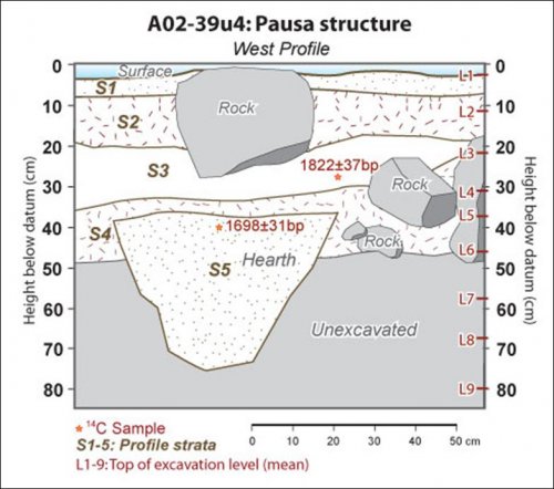
Figure 7-33. A02-39u4 Pausa test unit west profile diagram showing strata and levels.
Radiocarbon dates recovered from levels 3 and 5 of Unit 4 are temporally inverted, but they overlap in the 2-sigma error ranges. These dates place the later use of the hearth in the vicinity of AD200, or the Upper Formative. At units 3 and 4 at Pausa showed a relatively high percentage of obsidian by count throughout the sequence (83%), although by weight obsidian was somewhat less dominant (58%), while volcanics became more prominent (33%).
Artifacts by level
|
Level |
Proj Points |
Bifaces |
Cores |
Flakes |
Flakes Retouched |
Groundstone |
|
1 |
7 |
2 |
2 |
90 |
1 |
|
|
2 |
1 |
63 |
2 |
|||
|
3 |
4 |
1 |
1 |
67 |
2 |
|
|
4 |
3 |
59 |
1 |
|||
|
5 |
2 |
3 |
134 |
3 |
||
|
6 |
6 |
1 |
2 |
55 |
1 |
|
|
7 |
1 |
16 |
||||
|
8 |
2 |
|||||
|
Total |
24 |
7 |
5 |
486 |
9 |
1 |
Table 7-29. A03-39u3/u4 counts of lithics by level.
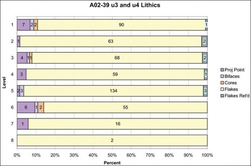
Figure 7-34. A02-39u3/u4 Bar graph showing counts of lithics classes by excavation level.
Classes of lithics from A02-39u3 and u4 show that demonstrable variability was occurring in activities in this area. All of the diagnostic projectile points were Series 5 points, all points were made from Ob1 obsidian except for one Ob2 point, and 80% of the points were broken. The complete points were found scattered in every level, and the series 5 types are consistent with the Late Formative dates from radiocarbon dating. Some of the points were extremely small, including one beautifully pressure flaked point [L03-60.3] that measured only 12.9mm long by 5.2mm wide, and 2.9mm thick weighing 0.1 g. The other points were all very small, with a mean weight of 0.6 grams, which suggests that the size of the projectile is not necessarily related to material abundance as obsidian was abundant at this location in the Late Formative and yet the projectile points were extremely small.
|
Level |
Complete Flakes |
Pressure |
% Pressure by Row |
Observed BTF |
Calculated BTF |
% Calculated |
|
2 |
46 |
1 |
2.1 |
1 |
5 |
10.9% |
|
3 |
45 |
2 |
4.3 |
1 |
8 |
17.8% |
|
4 |
41 |
0 |
2 |
10 |
24.4% |
|
|
5 |
97 |
1 |
1.0 |
3 |
18 |
18.6% |
|
6 |
36 |
0 |
1 |
2.8% |
||
|
7 |
6 |
0 |
2 |
33.3% |
||
|
Total |
271 |
4 |
- |
7 |
44 |
- |
Table 7-30. A02-39u3 and u4: Obsidian flake types by excavation level.
In level 5, between 50 and 60 cm depth and associated with the F1 hearth feature in south half of Unit 4, a distinct increase in obsidian reduction activity was encountered that suggests more advanced reduction activity was occurring in this period. Focusing only on complete obsidian flakes, reveals a much higher count of complete flakes per unit volume of dirt, a quantity that was more than double the number in other levels.
Leaving out level 1 due to surface contamination, the evidence from complete flakes suggests that while bifacial reduction was occurring in level 5, pressure flaking was relatively rare. Bifacial thinning flakes were noted by one of the analysts (Mackay) in the process of labwork (observed BTF column) but because other analysts were not making note of BTF during analysis, additional candidates for inclusion in the BTF category based on the BTF calculation model presented above appear in the column labeled "Calculated BTF". Both observed BTF and calculated BTF values suggest that during level 5 distinctive reduction activities occurred.
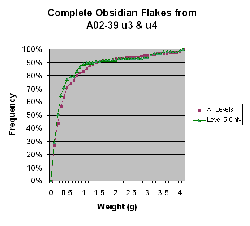
Figure 7-35. Cumulative Frequency of A02-39 u3 & u4 showing Level 5 reduction against reduction for all levels.
Figure 7-35 shows that there was a larger number of very small flakes in level 5, where over 75% of the complete flakes weighed less than 0.6 grams. Evidence of the conservation of material appears in levels 4 and 5, where complete flakes have a higher mean number of rotations and much smaller platform sizes. Finally, the mean coverage of dorsal cortex on flakes decreased from 6.9% in level 5 to 4.3% in level 4, while 6.4% is the mean for these units. In other words, there was a slightly greater range of reduction levels occurring in level 5 where there was more cortex but also a great many small flakes. By the next level, level 4, there was primarily decorticated material in use, and relatively little cortical obsidian.
Other artifacts include bone and ceramics throughout the sequence, and a few tiny pieces of turquoise in level 6 at the bottom of the hearth. Ceramics were found in every level in these excavation units, but few of them were diagnostic. Of the 38 sherds only four were rim sherds and two were handle pieces. One sherd found in level 5 had an incised line parallel to the rim, but was otherwise non-diagnostic. Five sherds from the lower levels (level 3, 5, and 7) resemble the "Chiquero" style described by Wernke (2003) with a brushed interior and no slip. Bone fragments were found in every level but none were diagnostic. Burned bone and charcoal in grey soil were found in particularly high density in hearth F1, along with a broken piece of groundstone and fire-cracked rock.
Discussion
Evidence from these test units suggest that the small hearth was built between windscreens and walls made of standing slab rocks. Based on the small size of the hearth and the structure size, the hearth seems to have been a residential feature. Assuming the overall site configuration at Pausa involved two large ovals of rocks that may be observed today, the structure that was encountered in unit 3 and 4 pits would be immediately north of the internal oval. These ovals may have been herd control features, such as large corrals with well constructed wall bases on slightly raised mounds, and this residential structure would have been constructed against the north perimeter of the inner circular corral feature. Evidence from lithic reduction show that advanced stages of lithic reduction were occurring here, and while the evidence of bifacial production and pressure flaking absent from the Chivay workshop area, such activities appear to have been occurring with greater frequency in Block 2.


