Stratigraphy
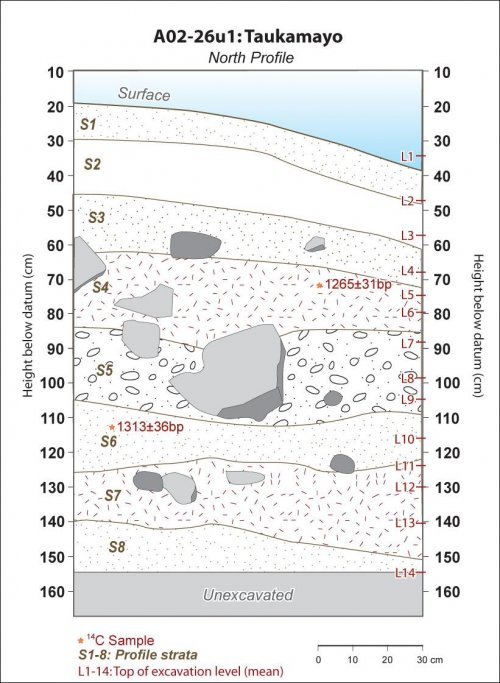
Inspection of the slope cut and the stratigraphy of the test unit confirmed that the site had not slid in the past and the stratigraphy was largely intact. There are signs of increasing angle of deposition through time. Sloping, colluviated soils gave way to level, well-sorted gravels near the bottom of the cultural levels. Radiocarbon dating indicated that the deposit is largely synchronic as the two sigma error of the radiocarbon samples overlap.
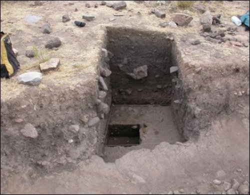
Figure 7-36. Test unit A02-26u1 is a 1x1m test unit placed on the edge of a creeping landslide with an irregular extension area (1x) on the south edge of the unit. Top of the photo is north.
The TU1 was placed immediately north of the cut slope, but because it was oriented to true north there was a small irregular, extra section to the south of the unit that dubbed A02-26u1 x. As a cut profile was available it was possible to observe that the ~60cm of overburden above the charcoal, bone, lithic, and ceramic layer in the profile was virtually sterile. The overburden was excavated relatively expediently by only screening only one-quarter of the dirt through 1/16" screen, the rest went through 1/4" screen only. By level 3 (58cm below datum) everything was screened through 16" screen.
|
Level |
H.B.D.* |
Contents |
Soil |
Photo # |
|
1 |
30 cm |
S1: All: 1/4" screen, Quad D: 1/16" screen. Few artifacts. |
Top of unit, grass, roots, light brown soil. |
3528 |
|
2 |
47 |
S2: All: 1/4" screen, Quad D: 1/16" screen. Few artifacts. |
Dark grey 7.5YR4/1. Compacted, organically rich, poorly-sorted, subangular .3/.9. |
3529 |
|
3 |
58 |
S3: All quads through 16" screen from here downward. Few artifacts. |
V. Dk Grey 7.5YR3/1, subangular blocky, med grain, poorly sorted, .7/.3 |
3532 |
|
4 |
65 |
S3, S4: 1, 0a (matrix). Rocks, roots, charcoal, bone, yellow clay blob. 14C: 1265±31bp (AD660-830) |
F1: Alluvial, V. Dk Grey/Brown: 10YR3/2, med grain, well-sorted,.5/.3. F2: 7.5YR3/1, med grain, well-sorted, .7/.3 |
3538-3541 |
|
5 |
75 |
S4: F1,F3. Bone, ceramics, many lithics, charcoal. |
F1: V. Dk Grey 7.5YR4/1, subangular blocky, coarse, poorly sorted, .9/.7 |
3546 |
|
6 |
80 |
S4, S5: F1. Bone, ceramics, many lithics, charcoal. Top of hoe. |
V. Dk Grey 7.5YR3/1, subangular blocky, med grain, poorly sorted, .7/.3 |
|
|
7 |
88 |
S5: F1, F3. Much bone on west side of unit, lithics, andesite hoe |
F1 and F3: V. Dk Grey 7.5YR3/1, coarse grain, poorly sorted, .7/.3 |
3573-3576 |
|
8 |
98 |
S5: F1, F4. Bone, ceramics, many lithics, charcoal, midden. |
F1: Alluvial, V. Dk Grey/Brown: 10YR3/2, med grain, well-sorted,.5/.3. F2: 7.5YR3/1, med grain, well-sorted, .7/.3 |
3600 |
|
9 |
105 |
S5, S6: F1, F4. In F4 there was ochre and obsidian, but less bone. 14C: 1313±36bp (AD650-780) |
F1 and F3: V. Dk Grey 7.5YR3/1, coarse grain, poorly sorted, .7/.3 |
3666-3667 |
|
10 |
116 |
S6: F1,F5. Lithics, ceramics, bone |
F1 and F5: V. Dk Grey 7.5YR3/1, coarse grain, poorly sorted, .7/.3 |
3673 |
|
11 |
124 |
S6, S7: Arbitrary div: 1a, 1b. Lithics, ceramics, bone |
F1 and F5: V. Dk Grey 7.5YR3/1, coarse grain, poorly sorted, .7/.3 |
3675 |
|
12 |
130 |
S7: Arbitrary div: 1a, 1b,1x. Mixed midden, charcoal, lithics, 2 clay concentrations |
Moist soils. V. Dk Grey 7.5YR4/1, subangular blocky, med. grain, med. sorted, .9/.7 |
3677 |
|
13 |
141 |
S7: Arbitrary div: 1a, 1b,1x Few lithics, 1 sherd, no bone |
Very moist soils. V. Dk Grey 7.5YR4/1, subangular blocky, med. grain, med. sorted, .9/.7 |
3679 |
|
14 |
156 |
Compact soil |
3684 |
|
|
* HBD = mean height below datum in centimeters for the top of each level based on five depth measurements. |
||||
Table 7-31. A02-26u1 test unit. Excavation levels, overview, and soil description.
Figure 7-37. A02-26u1 Taukamayo test unit, north profile diagram showing strata and levels.
The stratigraphy at A02-26u1 revealed that the site was intact behind the profile as no obvious landslide had disturbed the soils. There was a distinct change in angle approximately 60-80cm below the surface where the strata are at a much lower angle. These strata contain a great deal of charcoal and bone, and the radiocarbon dates place the assemblage at approximately AD700. This is the middle of the Tiwanaku period and it represents the beginning of the Middle Horizon. The slope angle change that is suggested by the soil stratigraphy is likely related to changes in the position or altitude of the adjacent creek. Evidence of alluvial sorting and river smoothed stones were also found in strata below the S4 and S5 occupation, which suggest that these occupations are on top of an old river terrace. Today, Taukamayo creek is approximately 40m vertical below the site altitude, and denuded hillslopes around the creek suggest that erosion is severe in this tributary valley to the Colca. A preliminary assessment is that Taukamayo creek has significantly incised since the Late Formative and Middle Horizon when it flowed below the site of A02-26 which lay on a relatively flat T1 terrace. Increased incising of Taukamayo creek first caused soil deposition to assume steeper angles, as is apparent in the upper 60cm of the profile. However in the more recent past the creek has begun to undercut the T1 terrace on which the site rests and the southern part of Taukamayo has since slid, revealing the profile cut.

