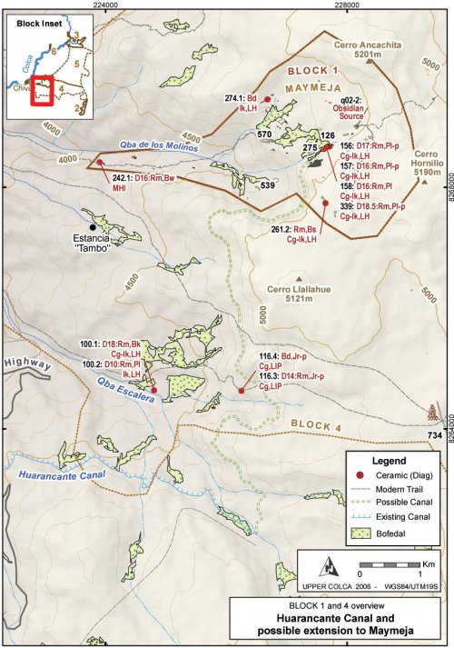
Possible Late Prehispanic canal route
As agricultural intensification and terrace construction accelerated during Late Prehispanic times, the volume of water entering canal systems from the high altitude headwaters would have become increasingly important to the farmers below. The Huarancante canal system that irrigates the southern half of the Colca valley has been discussed in more detail elsewhere (Brooks 1998: 203-213;Wernke 2003: 235-246). This canal irrigates some of the most productive farm land in the main Colca valley, including the area around Yanque, the dominant community during the LIP and LH. Any additional water contributed into the Huarancante canal system would have been of great utility downstream.
While no glaciers are found in the Maymeja area and the precise date of deglaciation of Cerro Ancachita and Hornillo are not known, the spring that irrigates the southern half of Maymeja has a relatively high volume of flow. This flow is particularly notable in this porous volcanic landscape, where much of the surface water disappears underground. The substantial volume of water that descends from here to Chivay was sufficient to justify the construction of a mill during colonial times (the apparent namesake of Quebrada de los Molinos). Today, this water powers a small hydroelectricity plant for Chivay.
According to Sr. Mamami (2005, pers. comm.), the owner of "Tambo", a rich estancia between Chivay and Cerro Hornillo, a canal existed that connected Maymeja with Huarancante in the past and it traversed high above eastern edge of his land. Upon further discussion with S. Wernke (2005, pers. comm.), the significance of a possible extension to the modern Huarancante canal is explored here, as this extension would have been an important asset had it connected the abundant perennial spring in Maymeja to the Huarancante canal.
A possible route using contours derived from the ASTER 30m topographic DEM layer is presented here. Following Brooks' (1998: 203) estimate of 1° or less downslope for the canal, the canal is extended up from the point at which the existing canal departs from Quebrada Huanta Occo at 4745 masl on the north slopes of Nevado Huarancante. The contour distance to the Maymeja bofedal is approximately 10.5 km, which, at a 1° slope, would require a vertical change of 183m, indicating that the canal would have had to begin at around 4928 masl. The altitude of the Maymeja workshop in site A03-126 is 4902m, therefore when extrapolated over more than 10km the gradient potential exists for such a canal, but it would have required losing very little altitude across difficult terrain. No specific cliff bands block the construction of such a canal, but a steep lava cliff passes immediately above the canal route and the slopes below this loose cliff consist of an incline of sand and talus at approximately 45°. These features would have presented a difficult obstacle to canal construction.
Under Inka rule, the Collagua extended their agricultural production through projects such as canal expansion, and the construction of such a canal would serve to explain, in part, the predominance of Late Horizon Collagua-Inka ceramics over LIP Collagua ceramics in the Maymeja area. Unfortunately, due to fieldwork time constraints, the Upper Colca survey project was not been able to conduct a pedestrian survey along this potential canal route. The route contours around an extremely high colluvation zone below the lava outcrops of Cerro Llalluhue, and a canal in this area would have required significant maintenance.
The possible canal route shown on Figure 6-67 and Figure 6-70 is 11 km long and drops from 4905 to 4745 masl at a gradient of 0.83°. No features definitively related to canal construction were observed, but further fieldwork could confirm Sr. Mamani's account. Another possibility is that the Inka-Collagua presence in the Maymeja area results from a work-in-progress where feasibility study measurements and initial work were perhaps underway for the construction such a canal in the 16thcentury when the Spanish arrived. A scenario such as this would have left somewhat ambiguous evidence in the Maymeja area.
Figure 6-70. Blocks 1 and 4 overview showing possible route of Late Prehispanic canal.
