4.1. The geography of the Colca Valley study area
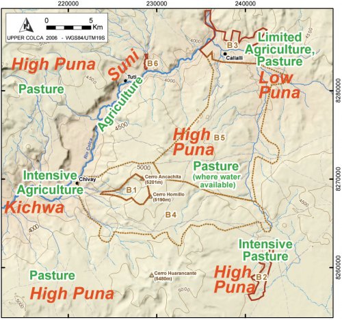
A brief review the geography of Upper Colca study area better contextualizes the ancient lifeways and relationships that are the subject of this dissertation. The 2003 research project was organized into three distinct blocks of contiguous survey (1, 2, 3) with other adjacent areas numbered 4, 5, and 6. The three major survey blocks correspond with ecological zones in the Upper Colca area and the overall ecological variability in the project area will be reviewed here by a discussion of each block.
Ecological complementarity between highland herders and valley agriculturalists is a widespread feature of Andean economy. Research into the productive potential of "pure" pastoralism in the Andes has shown that the caloric return and efficiency is insufficient to sustain communities without inputs from non-pastoral communities (Thomas 1973;Webster 1973). The Upper Colca study area lies immediately above the altitude of intensive valley agriculture that begins at the village of Tuti (3840 masl), corresponding with the upper portion of the suniand with the punaecological zones, and reflecting the local precipitation and temperature gradient (ONERN 1973: 39;Pulgar Vidal 1946). The town of Tuti is at approximately the altitude of Lake Titicaca, and in some ways the land use practices observable upstream of Tuti in the Callalli area are comparable to those in the Lake Titicaca Basin, although this western slope location does not have the moderating effect of the large lake body itself.
|
Local elevation |
Zone |
Description |
Upper Colca Survey Blocks |
|
4000 - 5000 |
Puna |
Rich pasture lands and rugged volcanic terrain in the Chivay obsidian source area, the San Bartolomé puna near Chalhuanca, and below to the town of Pulpera. |
1, 2, 4, 5 |
|
3600 - 4000 |
Suni |
High elevation agricultural lands, lower quality pasture, upper river valley from Chivay to Sibayo / Callalli. |
3, 6 |
|
3300 - 3600 |
Kichwa |
Lower portion of the main Colca valley. |
None |
Table 4-1. Andean ecological zones with approximate local elevation values for each zone.
Annual rainfall ranges from 550 and 750 mm, depending on elevation, and the average annual temperature is 1° C in the puna (ONERN 1973). In this area, precipitation is higher with altitude, but temperature, especially night time temperature, drops with altitude. The result is a balance between the potential for dryland agriculture, altitude, and climate that has periodically allowed farming in the Upper Callalli area in prehispanic and Hispanic times.
Figure 4-2. Survey blocks in the Upper Colca study area are shown with modern production zones described in Table 4-1. These zones reflect changes in altitude and rainfall as the Colca river, descending westward, is surrounded by puna pasture lands.
A relationship of mutual benefit exists between residents and resources of the higher altitude ecological zones and the vegetatively-productive main Colca valley. A principal assumption of this research is that the procurement of resources like obsidian have long been structured by the human use of complementary ecological zones. Some form of regular articulation between the highlands and the valley therefore probably existed through much of prehistory without special recourse for obsidian provisioning. This interaction may have taken the form of regular visits to the Chivay obsidian source area by valley agriculturalists, who may have been hunting or herding in the adjacent highlands, or by way of visits by highland pastoralists traveling from the puna regions in order to visit the Colca valley to barter for agricultural goods.
4.1.1. Climate across the study area
The Colca valley is located in the western cordillera of Andes in a semiarid climate that is cool and unpredictable. As a high altitude region of tropical latitude, diurnal temperature variation is more prominent than annual temperature variation (Denevan, et al. 1987;Troll 1968). Precipitation is highly seasonal, however, and it is changes in rainfall and availability of pasture that strongly influence the scheduling and intensity of pastoralism and dry land agriculture throughout the study area. The south-central Andes is a region south of 15° S latitude, outside of the Intertropical Convergence Zone, and precipitation is relatively unpredictable with high interannual variability because it results largely from the convection of humid air from the Amazon Basin to the east (Johnson 1976). The western slope of the Andes thus lies in a rain-shadow, and warm, dry winds from the east result in low average annual precipitation as one descends the western flanks of the Andes. In the ecotone that is the Upper Colca study area the herding economy thrives, because these communities can seasonally exploit the rich pasture lands and greater rainfall of the high puna while simultaneously interacting with the communities and products of the main Colca valley, communities to which they may have family linkages.
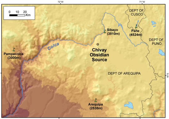
Of the major obsidian sources in the Andes, the Chivay obsidian source is the highest elevation source and the environmental conditions in the area during prehispanic procurement visits to the source are the subject of some speculation. Annual climatic variability under modern conditions at the Chivay source can be inferred from the relationship between altitude and temperature, known as the lapse rate, and this rate may be calculated using records from nearby meteorological stations. A mass of rising air will cool at the dry adiabatic lapse rate that is often estimated as 0.98° C per 100m of ascent for dry conditions, while the saturated adiabatic lapse rate is typically 0.5° - 0.6° C per 100m at dew point when temperatures are around 10°C (Adiabatic lapse rate 1999). This theoretical lapse rate may be compared with empirical temperature data reported by the ONERN environmental investigation, a regional study of the entire Majes-Colca drainage that preceding the construction of the Majes hydroelectric project. These data include mean monthly temperature records from meteorological stations at Pañe near the Colca headwaters, Sibayo on the northern edge of our Upper Colca study area, and the mid-altitude stations of Arequipa and Pampacolca (ONERN 1973;WMO 2006).
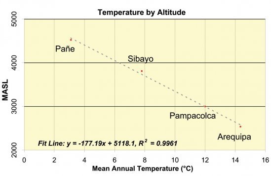
Figure 4-3. Temperature by Altitude at mid- and high-altitudeArequipa meteorological stations. All data from ONERN (1973) except Arequipa values from W.M.O. (2006). These data represent a lapse rate of -0.56°C per 100m of ascent.
These empirically-derived mean annual temperature values from the Arequipa sierra show a lapse rate of -0.56°C per 100m, which is in the range of the standard saturated adiabatic lapse rate of -0.5 to -0.6 per 100m, discussed above, from which can be inferred a mean annual temperature of 0.8°C at the Chivay obsidian source. Given the aridity of this region much of the year, the relatively low-slope (saturated) lapse rate is unexpected and the raw tabular data in the ONERN report suggests that a more detailed examination of the data will better allow the temperature variation at the Chivay obsidian source to be inferred.
Models based on local meterological data
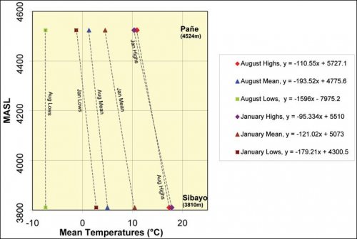
Monthly mean temperature data collected from 1952 - 1970 at local meteorological stations show highs, daily means, and lows, and the considerable differences from the lapse rate function that probably result from the dramatic diurnal temperature variations and the relatively thin atmosphere in this region. The seasonal effects on lapse rate can be considered by looking more closely at data from the nearest reliable weather stations, at Sibayo and Pañe.
Figure4-4. Comparison of Temperature highs, means, and lows for August and January from two meteorological stations with records kept between 1952-1970(ONERN 1973).
|
August (winter, dry) |
January (summer, rainy) |
||||||
|
Altitude |
Lows |
Mean |
Highs |
Lows |
Mean |
Highs |
|
|
Sibayo |
3810 |
-7.4 |
5.0 |
17.3 |
2.7 |
10.4 |
17.8 |
|
Pane |
4524 |
-7.8 |
1.3 |
10.9 |
-1.2 |
4.5 |
10.3 |
|
Maymeja |
5000 |
-10.2 |
1.0 |
6.6 |
-3.6 |
0.6 |
5.6 |
|
Temp. Change / 100m |
-0.5 |
-0.1 |
-0.9 |
-0.5 |
-0.8 |
-1.0 |
|
Figure 4-5. Mean monthly temperatures (°C) from data in ONERN (1973). Inferred temperatures at the Maymeja area of the Chivay obsidian source shown in italics.
Figure4-6. Precipitation by Altitude (left), precipitation in the study area (lines represent highs, averages, and lows) is highly seasonal as shown in 14 yr precipitation record from Sibayo on right. Data from ONERN (1973).
The local relationship between altitude, temperature, and precipitation on the dry western slopes of Arequipa are evident in these data derived from tables provided by ONERN (1973, Appendix II). Diurnal temperature variation, highest during the dry winter months of July, August, and September results in a steep lapse rate such that low temperatures in Sibayo, near the lowest part of the study area, are only 3° C warmer than those mean winter lows at the Chivay source. Curiously, the high temperature values cross over between summer and winter months (
Figure4-4) resulting in somewhat more of a temperature difference between Sibayo and Pañe during the rainy summer months than the winter months, probably reflecting the higher precipitation at altitude. As most precipitation, including snowfall, comes during the summer months of January and February, greater cloud cover and reduced solar insolation at altitude are expected during the summer months.
At the Chivay obsidian source the inferred temperature values are in keeping with observations made during the course of research at the source in August and September 2003, as will be discussed below. This is not to suggest that the modern climate regime existed during prehispanic times, but these relative contrasts in temperature and precipitation values throughout the Upper Colca study area probably have existed throughout the Holocene although actual precipitation and temperatures varied from those of the modern conditions. Paleoclimatic reconstructions from the Terminal Pleistocene and through the Holocene using data from cores collected in large lakes and glaciers were discussed in Chapter 3.
It is important to stress that adiabatic lapse rate temperature estimates do not account for other important factors affecting local climate such as local insolation, vegetative cover, and wind, as well as temperature contrasts due to solar heating where the atmosphere is thin, and temperature inversions in mountain valleys (uncommon at tropical latitudes). Further, orographic effects such as mountain and valley winds have specific and localized effects in the Upper Colca survey blocks. Seasonality in the upper Colca region includes rain and snowfall in the highest reaches during the wet summer months as well as a high incidence of lightning strikes (a major cause of death in the Peruvian highlands today). Modern herders in the Colca area adapt to these conditions by distributing their impacts and exploiting the high altitude resources primarily during the dry season.
The equatorial bulge in barometric pressure
An issue related to temperature variation is the presence of an equatorial bulge in atmospheric pressure as one ascends to high altitude (Ward, et al. 2000: 26-28;West 1996). In low latitude areas, barometric pressure at a given altitude is correspondingly higher than is pressure at that altitude in mid and high latitude areas of the world.
|
Figure4-7. Latitude against barometric pressure (West 1996). Lines show altitude in km. Annual temperature seasonality is minimal in the equatorial areas and thus seasonal effects at low latitudes are not shown in this graph. |
Models of variance in barometric pressure with latitude at a given altitude based on data derived primarily from weather balloons explain why there is greater available oxygen at 5000m in low latitude areas than in high latitude areas. The differences in pressure are particularly notable during high latitude winters.
|
Altitude |
15° latitude |
60° latitude, summer |
60° latitude, winter |
Equivalent Altitude |
|
4000 |
475 |
462 |
445 |
3479 |
|
5000 |
419 |
406 |
387 |
4400 |
|
6000 |
369 |
356 |
335 |
5310 |
Table 4-2. Equatorial bulge and effects on barometric pressure (in torr) at 15° and 60° latitude. From data in (West 1996: 1851). Equivalent altitude column shows altitude at 60° latitude with equivalent pressure to the value shown at 15° latitude.
As shown in Figure 4-7 and Table 4-2, the equatorial bulge in pressure means that the available oxygen at the Chivay source at 5000 masl is only close to the pressure that of a location nearly 1000m lower if the source were located at 60° latitude (in winter). In other words, during the winter at 60° latitude, at approximately the latitude of Anchorage Alaska, one would have to be at only 4400 masl altitude to find available oxygen at levels equivalent to that found at 5000 masl at the Chivay source. Barometric conditions similar to those found near the summit of Nevado Ampato at 6000 masl can be found in winter at 5310 masl near Anchorage, AK. The high altitude Chivay source is not as inhospitable as would be this zone at the equivalent altitude in higher latitude areas. Resource patches, such as rich bofedal grazing areas, are sufficient to draw seasonal or permanent residents to these altitude zones in the Andes. Raw material sources, particularly mining operations, are another significant draw to high altitude locations both in past and in modern times (Ward, et al. 2000: 336-344).
4.1.2. Lower elevation biotic zones: Study Area Blocks 3 and 6
Beginning with the lower elevation part of the survey area and moving upstream, the vegetation of the Colca valley above Tuti consists of low grasses dominated by the ichuvariety during the dry season. The Colca River is relatively low gradient in this area, and two or three levels of natural river terraces are evident along the valley margins. The geography of the zone is dominated by the fact that the confluence of two large river systems (Colca and Llapa) occurs here. This area holds the largest settlements in our study area, but both agriculture and pasture appear marginal in immediate area of these towns. Rather, the settlement of the upper river valley seems to reflect the importance of the articulation between the main Colca valley and the broad altiplano. The village of Sibayo rests precisely at the main confluence of the Colca River and the Llapa River, and as is evident in the Shippee-Johnson expedition, Sibayo has long served as a principal modern ingress to the Colca Valley until the Chivay-Arequipa highway was completed (Shippee 1932).
Settlements
The bulk of the contemporary populations in the study area reside in towns in block 3 established during the colonial period that are distributed along the Colca river. The largest settlement inside the study area is Callalli, a town with a 1993 population of 1295 persons, and across the Colca River the population of the town of Sibayo is 508, and upstream in Block 5 the cooperative of Pulpera numbers 85 residents (I.N.E.I. 1993). These towns are primarily service centers and district seats for widely distributed populations with an economy based largely on pastoral products, and on extensive interaction through trade with their wealth in camelid herds, and have long resided in rural hamlets and herding outposts. Callalli and Sibayo first formed as part of the sixteenth century reducción of the Yanque Collagua, and in the colonial period the province of Collaguas (Caylloma) held three-quarters of the livestock in all of Arequipa (Cook 1982;Manrique 1985: 95-96). The dominance of the herding economy in these upper valley towns is evident in the 1961 census where both Callalli and Sibayo populations are reported as 93% "rural", while the average percentage for all nineteen towns in the Colca census, including large and dense agricultural communities downstream, was only 52% "rural" (Cook 1982: 44).
These early villages also formed an important source of labor for colonial mining ventures in the Cailloma region (Guillet 1992: 25-27). Mercury and copper were mined between Callalli and Tisco (Echeverría 1952 [1804]) and Lechtman (1976) reports a structure in Callalli known as " La Fundición" that is described as "stone metal smelter, probably colonial, said to be for copper smelting: mineral, scoria on surface". A location known as "Ccena" or "Qqena" is described as having "metal smelters near a pre-Spanish occupation site: mineral, scoria, surface sherds" (Lechtman 1976: 11). The toponym "Ccena" can be found close to the Llapa and Pulpera stream confluence upstream of Callalli. These historical smelters were not encountered during the course of our survey in this particular area.
Pyrotechnical installation
One structure ([A03-842], Figure 4-8) was identified in the course of the 2003 survey that appears to be of colonial period construction and it appears to have some kind of pyrotechnical function (B. Owen 2006, pers. comm.). The structure has two doors in the lower area, apparently providing access to the lower furnace. The internal lower construction is built of thermally altered stones and has a cracked lintel. A variety of pyrotechnical structures are known in the south-central Andes (Van Buren and Mills 2005) that were used to heat lead, silver, or copper, and other oven types (e.g., pottery, bread) are known in the region as well. Slag or other evidence of smelting was not encountered in the soils adjacent to the structure, however, although the building is immediately adjacent to a stream channel and such materials may be eroded or difficult to detect.
Figure 4-8. Exterior and interior of probable colonial pyrotechnical structure at Achacota near Pulpera, upstream and south of Callalli [A03-842]. One meter of exposed tape is visible in each image.
Vegetation and dryland agriculture in the study area
The Callalli area consists primarily of high elevation grassland punaecology (1973). Dry bunch grasses are available much of the year in this area, but during the wet season (austral summer) a greater variety of grasses become available and herds are brought to the valley to exploit the pasture of chilliwuaand llapagrasses.
Callalli and Sibayo lie in the upper reaches of agriculture at this latitude and evidence of abandoned fields are visible in the upper valleys. Plants like tubers, oca, and chenopodium were historically viable at this altitude (Echeverría 1952 [1804]), although microclimatic variability is influential in these conditions of marginal dryland agricultural production. Guillet (1992: 24) cites evidence for climate change from historical sources that describe the cultivation of maize above the current limits for this crop, and coca, membrillo, and peppers on terraces that lie at altitudes where these crops are not feasible today. Wernke (2003: 51-52) considers the significance of climate change evidence from ice cores in mountain ranges to the east for Colca valley culture history and agriculture.
In Markowitz's (1992) ethnographic study at Canaceta, a village at 4000 masl and approximately 12 km upstream of Callalli, villagers explained that they had formerly engaged in agriculture at this altitude, but that they had recently abandoned the practice due to lack of rainfall. She observes that practicing a mixed subsistence system of agriculture and pastoralism was an important cultural ideal in the Canaceta, but that in recent years due to changes in the climate and in economic circumstances they had increasingly become specialized on pastoral production complemented by exchange (Markowitz 1992: 48). Under modern circumstances there is probably not a very high return on labor invested in agriculture in this area as the increased economic integration, and an improved transportation infrastructure with intensive farming areas at lower elevations, has further induced residents towards specialized economic practices. The current distribution system emphasizes pastoral production in the highlands and higher yield agriculture on lands at lower elevations.
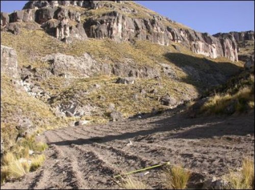
Figure 4-9. Tuber cultivation at 4200 masl surrounded by large tuff outcrops.
In the course of survey in 2003 cultivation was observed in a few high altitude locations, such as the upper reaches of Quebrada Taukamayo. The plots were at 4200 masl in a north-north-east facing (10°) aspect and a mild slope (8°). The area is relatively sheltered by the presence of lava tuff flows (see Figure 4-9) that may have had a temperature moderating effect acting like large terrace stones that are known to reduce diurnal variation by absorbing heat during the day and releasing heat at night in the immediate valley microclimate (Schreiber 1992: 131).
Flora and fauna
Important flora and fauna to residents of the Upper Colca region include the following (Gomez Rodríguez 1985;Guillet 1992: 130;Markowitz 1992: 42-44;Romaña 1987;Tapia Nuñez and Flores Ochoa 1984). Major flora comprise grasses such as Chilliwa( Calamagrostis rigescens), a frost-resistant perennial grass that thrives during the rainy season and in bofedales, grazed by a wide range of animals and also used for roof thatching. Other important puna pasture grasses include llapa, malva, sillo, and paco,though these are principally consumable by herbivores only during the rainy season. Ichu/ Paja( Stipa ichu) is a common grass used for thatching. In the higher elevation bofedales one can encounter parru, a grass preferred by alpacas. Wild fruits are gathered seasonally by locals including locoti(cactus fruit), q'ita uba(wild grapes), and sanquayo(a plant related to chirimoya) (Markowitz 1992: 43). In the high elevation area of the obsidian source yareta( Azorella compacta), a green, flowering cushion plant is one of the few flora that grow in the unirrigated areas of this harsh volcanic terrain. In addition to animal dung, dried yaretais the only dense, combustible fuel widely available above 4500 masl. As a local herder, T. Valdevia demonstrated, the cushion plant will burn when it is kicked over and allowed to dry out for several weeks. Drought and cold-resistant shrubs, including tolaand cangi, are valuable sources of firewood in the punatoday, though the shrubs are over harvested in many areas.
Fauna species include a number of birds that are hunted for their meat including the Grey Breasted Seedsnipe known as puko elquio( Thinocorus orbygnianus), partridges ( pishaq), and the guallata,the large white Andean Goose (Chloëphaga melanoptera)(Hughes 1987;Markowitz 1992: 43) .Several Andeancondors ( Vultur gryphus), for which the Colca is renowned, flew repeatedly near our work at the Chivay obsidian source in 2003. Wild mammals observed in the study area include viscacha( Lagidium peruana), tarucadeer ( Hipocamelus aticensis), and the wild camelid vicuña (Vicugna vicugnaor Lama vicugna).Thetrout found in the streams represent an important food source, but these fishes were introduced in the nineteenth century.
4.1.3. High Puna: Block 2 survey and adjacent Blocks 4 and 5
This high altitude zone of the study area is dominated by the Pliocene lavas and Quaternary moraines, as will be described in more detail below in the geology section. Much of these survey blocks consisted of porous lava rock and sandy soils covered by a mantle of ash, lapilli (rock fragments between 2 - 64 mm across) and the occasional volcanic bomb (molten rock between 64 - 1000 mm). During the dry season surface water was available only sporadically across the area and, unsurprisingly, reliable water sources frequently have archaeological sites nearby. The renowned "Ventanas del Colca" tuff formations occur on the edge of the San Bartolomé survey area (block 2) at the point where the highway connecting Callalli with Arequipa climbs out of the Pulpera drainage and straightens out for its run across the open puna grassland.
This area is also remarkably wet, the environment is productive, and faunal density is relatively high. Even during the dry season the Block 2 area has reliable water.
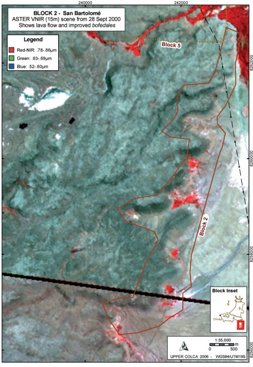
Figure 4-10. ASTER scenes with the terminus of volcanic breccia outcrop in green, photosynthesizing plant areas (bofedales) shown in red pixels, and ash in white. The black diagonal line is a seam between the two scenes.
Block 2 geography
Block 2 can be characterized as containing rich bofedales, reliable hunting opportunities, and access to lower Colca Valley resources only two-day's travel away. This area, known as San Bartolomé, can be considered a "puna rim" ecological area because animal and plant species are affected by the presence of lower elevation Colca Valley environments immediately downhill to the north and west, and warmer air rises from the lower valley affecting the local climate. The Pliocene eruption of the Barroso group vents of Huaracante, Hornillo, and Ancachita resulted in the predominantly silicic coulee flows of lava described as "Centro Huarancante" by the INGEMMET study (Palacios, et al. 1993: 139). On the eastern edge of the Huarancante Group the viscous lava flows terminate in breccia outcrops where they overlie crystalline ignimbrites (TBa-c) of older Pliocene age, also belonging to the Barroso formation. Below the toe of the lava the crystalline ignimbrites rich in dacite appear as light colored, sandy soils, where perennial surface water has created good grazing opportunities in this flat expanse to the east of the lava flows. Bofedales are found below each quebrada descending from the lava formations, a pattern that is perhaps the result of subsurface water moving through the lava flows and emerging at the contact zone with the ignimbrite formation.
A number of small rock shelters occur along the base of the upper lava flow. The rock shelters are typically dry, but the floors are sloping out onto talus slope below and so they offer little in the form of shelter inside the drip line. There are some notable exceptions, as will be reported in Chapter 7, and relatively dense occupations were found at few of the best rock shelters. On the whole, Block 2 follows along the eastern periphery of a lava flow where there is a concentration of resources. Water emerges from the lava onto the open pampa, grazing opportunities for wild and domestic herbivores on the bofedales and adjacent grasslands are good, and Andean geese and other puna bird species are seen in the greatest numbers. The lava flow provides topographic variability on the perimeter of a wide and often windy plain, providing shelter and occasional, small rock shelters.
Figure 4-11. View of San Bartolomé (Block 2) area during the dry season from atop a toe of Barroso lava looking northeastward. For scale, our white pickup truck is visible below. A rich bofedal is visible 3 km to the northeast.
Current environmental conditions suggest that the edge of the lava flow served as a rich ecotone with water, shelter, and numerous hunting opportunities for bird species, vicacha, tarucadeer, mammals, and probably the wild camelids guanacoand vicuñaat certain times in the past. We often observed a number of wildlife species in the course of research in this area including viscachaand geese, and perhaps the density of wildlife in this locale was due in part to lack of surface water elsewhere, on the adjacent lava beds and ashy soils. Even well into the dry season, parts of Block 2 area have reliable water and soft grasses.
Regional geography
Block 2 is a natural bottleneck for economic traffic moving between the Colca and the Titicaca Basin along what may be interpreted as the prehispanic trail system. Due to the steep descent to the Pulpera on the north side, and the glaciated volcano Nevado Huarancante on the south-west side, many travelers would probably have traveled through Block 2. The presence of a very large bofedal and rich hunting opportunities in the adjacent lava flows to the west probably made the Block 2 area an even greater attraction for travelers with caravan animals. This area lies on the periphery of the Colca valley and it is approximately one long day from the rich grazing areas of the Escalera access to the Colca valley, and about two days from the town of Yanque.
4.1.4. The Chivay Source: Block 1
The geological source of Chivay obsidian is above 4800 masl among the lava flows from two Barroso (Pliocene) volcanic vents named Cerro Ancachita and Cerro Hornillo. The discussion here focuses on the geographical context of Survey Block 1, and the geology of these volcanic features will be explored in more detail in Section 4.3.3, below.
In the high altitude portions of the Upper Colca survey, most notably in the Chivay obsidian source area above 4800 masl, the local temperature and climatic exposure is strongly affected by the lack of vegetative cover and the katabatic (mountain breeze) and anabatic (valley breeze) winds. The winds were a daily feature during the Block 1 fieldwork in the months of August and September 2003, and the winds are most notable in the mornings and evenings when the temperature differential between the high altitude areas and the warmer Colca Valley are greatest. Extrapolating the local lapse rate from Colca meteorological stations suggests that the obsidian source, at around 5000 masl, would have mean temperatures of 0.5 to 1.0° C year-round (
Figure4-4), not accounting for the effects of wind in this exposed area. In the course of fieldwork daytime high temperatures were approximately 5° C, and nighttime temperatures were commonly -9° C with the coldest night measured at -12° C. These data largely corroborate the estimates derived from the local adiabatic lapse rate discussed above.
