5.10.1. The All ArchID Centroids file
The added complexity of managing data through 1:M relates and distributing the recording of archaeological feature types among multiple GIS feature layers can be alleviated by creating a single file reference dataset. The concept is based on the ArchID numbering system described above (Section 5.3.5). Because all archaeological features that were individually mapped, including lithics, ceramics, and structural loci, shared a single number series, then a number list could be generated that is comprehensive and serves as a "backbone" against which to structure Many-to-Many relates.
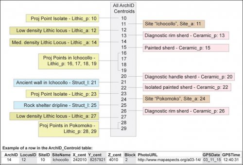
Figure 5-13. The All_ArchID_Centroids table provides a single reference layer for all the ArchID numbers used in the project, and allows relates to occur between disparate data layers. This figure shows the structure of these different layers using artificial data.
Many-to-Many (M:M) relates consist of a series of 1:M relates linked through a file structure that contains key fields in held common by the different tables, and this structure allows for relates to move across different file types. An example of queries moving between different layers would include the following: one needs to know if there is a statistical association between the percentage of obsidian among simple flakes in lithic assemblages in Ichocollo (Figure 5-13), and the rim diameter of LIP painted ceramics at that site. All the lab results from the archaeological features within Ichocollo showing obsidian percentage can be selected and related to the ArchID numbers, which in turn are related to the Ceramic_p layer containing the rim sherd diameter information. The problem is that some of these features are lines and polygons, while others are points, thus a single lookup table reconciles all these differences and allows relates to occur.
This file, referred to as All_ArchID_Centroids, is a single point-type file containing the point locations, and in the case of lines and polygons, the centroids of these features. This GIS layer is a single comprehensive list of all geographical proveniences, although the spatial detail and topology of lines and polygons is obviously lost when centroids are used. The table from the All_ArchID file can accompany lab data into statistical software packages to allow very general geographical queries on lab analysis results, such as patterns by common Locus, by Survey Block, and other queries that do not require GIS.
In sum, this post-fieldwork processing step involves creating the comprehensive list of ArchIDs that were used throughout the field season from the multiple file types described above in Figure 5-7a and creating a single GIS point geometry file from the cumulative list. The All_ArchID_Centroids file proved to be extremely useful in later GIS and lab analysis. The point location centroids for all feature types contains sufficient detail for many of the later geoprocessing steps, and the All_ArchID_Centroids layer was used as single location for labeling and for providing a structure for linking to photos on external website URLs.

