A03-1014 "Chiripascapa" [A03-1014 - A03-1057]
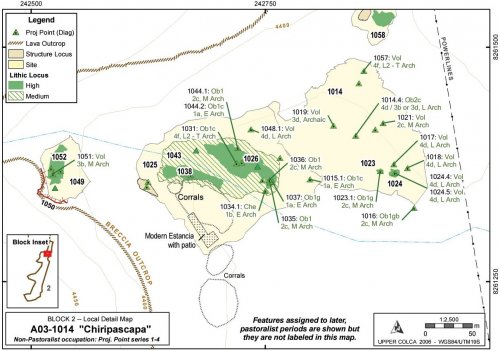
Chiripascapa was recorded as three sites due to variability in the artifact distributions and the differences in topography. Due to downslope movement in the steep talus zone in one portion of the site, and deflation in the lower site complex, the Archaic Foragers component of this site complex will be described as one group.
|
ArchID |
SiteID |
FileType |
Description |
Area (m2) |
|
1014 |
1014 |
Site_a |
"Chiripascapa" |
24,550,334 |
|
1023 |
1014 |
Lithic_a |
Medium Dens, 100 Obs |
38,785 |
|
1024 |
1014 |
Lithic_a |
Medium Dens, 89 Obs |
124,943 |
|
1025 |
1025 |
Site_a |
"Chiripascapa2" |
27,927,630 |
|
1026 |
1025 |
Lithic_a |
High Dens, 100 Obs |
2,470,331 |
|
1038 |
1025 |
Lithic_a |
High Dens, 30 Obs |
1,086,213 |
|
1041 |
1025 |
Ceram_a |
Painted LIP |
186 |
|
1043 |
1025 |
Lithic_a |
Medium Dens, 100 Obs |
9,484,728 |
|
1045 |
1025 |
Struct_a |
Wall Bases Only, Cave |
128 |
|
1052 |
1025 |
Lithic_a |
Medium Dens, 100 Obs |
888,906 |
|
1049 |
1049 |
Site_a |
"Chiripascapa3", Rock shelter |
3,657,074 |
Table 6-26. Loci in Chiripascapa
Description
The upper part of Chiripascapa consists of one medium sized rock shelter and three small rock shelters at the base of an east-north-east facing portion of the Huarancante volcanic breccia lava flow escarpment. Below the rock shelters a sloping talus field (a 25° slope), littered with lithics as well as ceramics, leads to a small intermittent stream 20 vertical meters below the rock shelter. On the banks of this stream is a scatter of lithics and ceramics from a variety of time periods that extend downstream for approximately 300 m. The south bank of the stream has a modern estancia (Pausa) and a large corral below the associated buildings, seriously disturbing any artifact scatters on the south bank. The north bank of the stream is also disturbed. Large scars from bulldozers scraped off the topsoil in certain areas. The resident at the Pausa estancia explained that during the 1970s highway improvement for the Majes Project the road crews caused these impacts as they were looking for gravel sources in that area. Just north of this site complex is a large, active gravel pit.
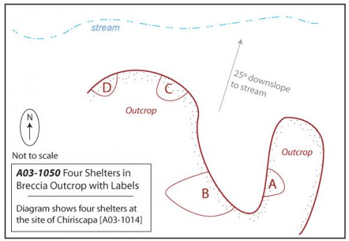
Figure 6-18. A03-1050 consists of four rock shelters: A, B, C, and D.
Figure 6-19. Chiripascapa [A03-1014], Archaic Foragers occupation.
A03-1050 - Four rock shelters of Chiripascapa
These rock shelters appear to be well situated with respect to the surrounding geography. The shelters face east-north-east and so despite being in a dark and slightly damp corner of the lava toe they catch the morning and midday sun. It is worth noting that the estanciadepicted in the center of the map appears to be deliberately built with the same aspect. The rock shelter is relatively well-hidden because it lies about 50m up a side quebrada and therefore goes unnoticed unless you climb the quebrada. Despite the concealed position, this location actually offers a partial view of the most important resource in the zone: the bofedal one km to the north-east. It would also be possible to monitor travel through the Ventanas del Colca access to the upper Colca from this hidden location. The stream below the shelters was dry at the end of the dry season, but probably flows most of the year.
Due to low GPS reception in the rock shelter area the four rock shelters were mapped as a single Struct-L line "A03-1050" and differentiated as A, B, C, and D. Only one shelter, the one designated as A03-1050B, had the characteristics of a residential shelter. The dimensions of this shelter are as follows. Height:2m, Depth:6.5m, Width:7m. Due to the overhanging roof formed from the lava flow, a considerable area is dry outside of the walls of the cave. This area shows signs of having been improved as a patio and the "patio" area extends the depth of the dry zone by another 12.5m. The rock shelter 1050A was large but wet, and 1050C and 1050D were very small but dry.
Below the rock shelters a talus slope extends approximately 20 vertical meters to the stream. A variety of lithics and ceramics were identified on this slope, though only one projectile point was diagnostic to a period that falls in the Archaic Foragers timespan. This point [A03-1051] was a Middle Archaic andesite point and it had a transverse snap and missing its haft element, suggesting that it was broken in use.
Features and Artifacts
The stream enters the open, sandy soils of the pampa and on either bank of the stream, though primarily on the north bank, projectile points from throughout the Archaic sequence were found. Preservation is relatively poor on this section of the pampa. In addition to the bulldozer impacts mentioned above, the soils appear deflated and this partly explains the high density of projectile points, from virtually every time period, found in this area. It seems possible that the entire site scatter was formerly more aggregated on the western part of this map, and with riverine transport the artifacts have been scattered over the pampa.
|
ArchID |
Artif. # |
Material |
Form |
Type |
Temporal |
|
1015 |
1 |
Obsidian |
Proj Point Broken |
1a |
Early Archaic |
|
1016 |
1 |
Obsidian |
Proj Point |
2c |
Middle Archaic |
|
1017 |
1 |
Volcanics |
Proj Point Broken |
4d |
Late Archaic |
|
1018 |
1 |
Volcanics |
Proj Point |
4d |
Late Archaic |
|
1019 |
1 |
Volcanics |
Proj Point |
3d |
Archaic |
|
1021 |
1 |
Volcanics |
Proj Point Broken |
2c |
Middle Archaic |
|
1023 |
1 |
Obsidian |
Proj Point |
2c |
Middle Archaic |
|
1024 |
4 |
Volcanics |
Proj Point |
4d |
Late Archaic |
|
1024 |
5 |
Volcanics |
Proj Point Broken |
4d |
Late Archaic |
|
1026 |
3 |
Obsidian |
Proj Point |
1b |
Early Archaic |
|
1031 |
1 |
Obsidian |
Proj Point |
4f |
Late-Term. Archaic |
|
1034 |
1 |
Chert |
Proj Point |
1b |
Early Archaic |
|
1035 |
1 |
Obsidian |
Preform |
2c |
Middle Archaic |
|
1036 |
1 |
Obsidian |
Preform |
2c |
Middle Archaic |
|
1037 |
1 |
Obsidian |
Proj Point |
1a |
Early Archaic |
|
1044 |
1 |
Obsidian |
Preform |
2c |
Middle Archaic |
|
1044 |
2 |
Obsidian |
Proj Point |
1a |
Early Archaic |
|
1048 |
1 |
Volcanics |
Proj Point |
4d |
Late Archaic |
|
1051 |
1 |
Volcanics |
Proj Point Broken |
3b |
Middle Archaic |
|
1057 |
1 |
Volcanics |
Proj Point Broken |
4f |
Late-Term. Archaic |
Table 6-27. Diagnostic Series 1 through 4 projectile points from Chiripascapa [A03-1014].
The temporal distribution of projectile points from Chiripascapa shows that virtually every time period is well represented. One distinction worth noting is that obsidian is used almost exclusively in the later time period, while about 50% of the projectile points (by count) are made from obsidian in the early time periods presented by Series 1 - 4 points.
|
Projectile Points |
Obsidian |
Volcanics |
Chalcedony |
Chert |
|
Series 1 - 4 |
10 (48%) |
9 (43%) |
1 (5%) |
1 (5%) |
|
Series 5 |
24 (96%) |
1 (4%) |
0 |
0 |
|
Total |
34 |
10 |
1 |
1 |
Table 6-28. Representative proportions of material types by projectile point styles.
The medium and high density lithic loci along the creek banks are difficult to temporally isolate because there are later period diagnostics, including twenty-six Series 5 projectile points and ceramics dating from the Middle Horizon, LIP, and Inka periods found in the A03-1038 lithic locus. Most of the flakes observed at this site were obsidian and chert. A small concentration of andesite flakes on the south bank of the stream in locus A03-1038 was observed, despite the fact that all andesite projectile points came from the north bank of the stream.
|
Material Type |
Obsidian |
Volcanics |
Chalcedony |
Chert |
Quartzite |
|
No. |
88 (62%) |
32 (23%) |
5 (4%) |
15 (11%) |
1 (0.7%) |
|
Mean Wt (g) |
5.05 |
18.28 |
16.7 |
10.91 |
11.5 |
|
% by Sum Wt |
34.5% |
45.6% |
6.7% |
12.3% |
0.9% |
Table 6-29. All lithic artifacts from Chiripascapa.
The surface materials included bifaces, cores, and flakes of all local material types except quartzite, which was rare at the site. Based on the mean flake size and the percentage of the total contribution by weight, fine-grained volcanics appear the most local to the area. Isolating any one of the lithic concentrations to a particular time period is difficult, but when viewed collectively including the point scatters in A03-1014 and A03-1025, and the rock shelters in A03-1049, the site complex is one of the oldest residential areas in the larger study area. The rock shelter A03-1050B and the built up patio has a high probability of containing a stratified intact deposit that extends into the earlier parts of the Archaic.


