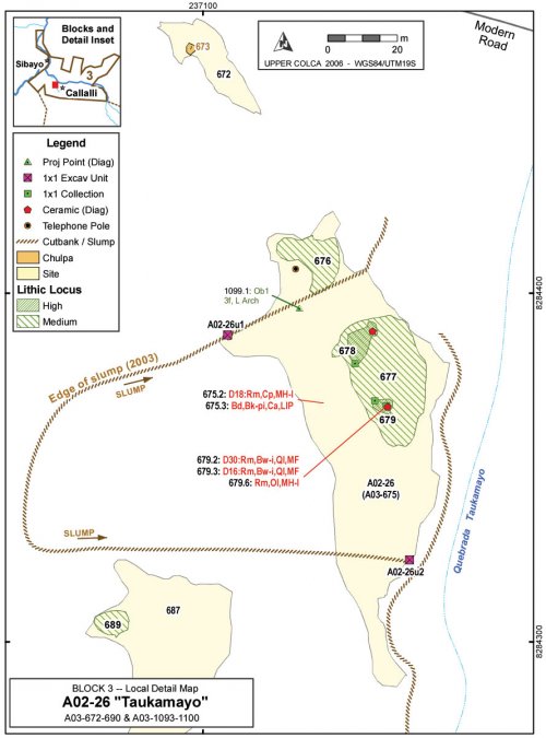
A02-26 "Taukamayo"
The multicomponent site of Taukamayo sits on a terrace above Quebrada Taukamayo just west of the modern town of Callalli. In the course of the 2003 survey the site was surface mapped as A03-675 in keeping with the 2003 survey methodology, but the official site number on the test excavation permit is A02-26. The site was tested with a 1x1m test unit and two partial units that produced dates circa cal AD650 (Section 7.6.1).
The site is located on a terrace above a tributary to the Río Llapa immediately upstream of the large confluence with the Río Colca. Located in a parcel owned by Noemi Ramos, who resides primarily in Arequipa, the site is located across Taukamayo creek from the modern village of Callalli. The town site of Callalli has Inka and possibly earlier components evident on the western edge of the town limits, but the occupation encountered at Taukamayo is earlier.
It is possible that Taukamayo was a peripheral site to the principal settlement at Callalli. Nielsen's (2000: 465-468, 490) ethnoarchaeological research on camelid caravans notes that when caravans stop overnight at settlements they will frequently camp in areas segregated from the principal settlement for two reasons. First, interference in the activities of residents, stampedes, and other forms of conflict can be avoided by remaining on the periphery of the settlement. Second, the agricultural fields can be better defended from caravan animals by camping a prudent distance from farm plots. In the modern trail system the principal route linking the Callalli area with the Chivay obsidian source and other high puna regions to the south climbs the Taukamayo drainage. Thus, Taukamayo may have represented a kind node in a larger transportation network because it is a relatively large site lying precisely in the area where the highland trail system joins the river network, but it is across the drainage from the settlement of Callalli.

Figure 6-62. Taukamayo [A02-26], a multicomponent site partially destroyed by a landslide.
Figure 6-63. Overview of Taukamayo [A02-26] on slump along base of hillside. Grey box shows area detailed in Figure 6-64, below.
Figure 6-64. Taukamayo [A02-26] detail showing two test units locations on cutbank margins of the creep area. Excavators are visible on right-side at A02-26u1 and provide scale for photo.


