A03-126 "Maymeja 1"
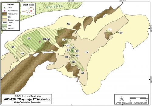
On the southern edge of Maymeja a site was located that contained a dense mound of flaked obsidian, an extensive scatter of obsidian, traces of terracing and wall building, but virtually no ceramics. Dates from a 1x1m test unit [Q02-2u3] placed in the obsidian mound (Section 7.4.2) showed that this site was occupied from at least the Terminal Archaic until the end of the Early Formative.

Figure 6-50. A03-126 "Maymeja 1" workshop and vicinity.
Maymeja 1 [A03-126] belongs to a complex of features that have been divided into an upper site A03-126, and a lower site A03-275 that has some LIP and LH component. This complex is located on the dry southern margins of the Maymeja area where viscous lavas emanating from the Cerro Hornillo vent slope downwards to the northwest into the depression referred to as Maymeja. Subsequent glaciation polished these lavas into smooth banks with excavated depressions that offer adequate shelter in this exposed region. The shelter and abundant sun in this north-facing zone is compensated for by the mountain winds that blow with regularity in the area.
Figure 6-51. View of A03-126 "Maymeja" from north. Terraced area A03-334 on upper level. Test Unit Q02-02 is just right of the orange bucket. Project tents are visible in corral A03-127.
|
(a) |
Figure 6-52. (a) Workshop area of "Maymeja 1" showing proximity of bofedal, (b) Testing Q02-2U3, with the quarry pit [Q02-2] visible among light ash 600m uphill in the background.
The residential base of A03-126 consists of two principal zones that show human modification: (1) the upper area above the polished lava bluffs visible in Figure 6-51, and (2) a lower zone that abuts the bofedal to the north. As the area is almost devoid of ceramics the primary indicators of occupation are lithic scatters of varying density and with highly eroded walls and terraces. The central greatest concentration of flaked stone is the workshop area labeled as a high density lithic locus [A03-330], shown on Figure 6-50.
|
Arch_ID |
Site_ID |
Feature Type |
Description1 |
Description2 |
Area_m2 |
|
126 |
126 |
Site |
"Mayemeja 1" |
Workshop and upper sector |
6,007.0 |
|
127 |
126 |
Structure Locus |
Walls |
Corral area |
130.6 |
|
275 |
275 |
Site |
"Mayemeja 5" |
Lower slopes parallel to bofedal |
10,401.4 |
|
276 |
275 |
Structure Locus |
Wall bases only |
Eroded terraces along lower slope |
1,414.2 |
|
277 |
275 |
Structure Locus |
Wall bases only |
Eroded terraces along lower slope |
978.2 |
|
278 |
275 |
Structure Locus |
Wall bases only |
Eroded terraces along lower slope |
524.6 |
|
279 |
275 |
Structure Locus |
Wall bases only |
Eroded terraces along lower slope |
1,234.2 |
|
280 |
275 |
Structure Locus |
Wall bases only |
Eroded terraces along lower slope |
4,306.6 |
|
324 |
126 |
Lithic Locus |
Medium Density |
Concentration in on top of lava outcrop |
49.6 |
|
325 |
126 |
Lithic Locus |
High Density |
Flakes washing down from structures |
12.4 |
|
326 |
126 |
Lithic Locus |
High Density |
Concentration in sheltered area |
4.5 |
|
327 |
126 |
Lithic Locus |
Medium Density |
Expanse of flaked stone |
182.4 |
|
328 |
126 |
Lithic Locus |
Low Density |
Light scatter coterminous with site bndy |
2,942.7 |
|
329 |
126 |
Lithic Locus |
Medium Density |
Expanse of flaked stone |
940.5 |
|
330 |
126 |
Lithic Locus |
High Density |
Workshop mound |
292.1 |
|
333 |
126 |
Lithic Locus |
Medium Density |
Concentration in sheltered area |
15.6 |
|
334 |
126 |
Structure Locus |
Wall bases only |
Eroded terraces along lower slope |
1,504.4 |
|
335 |
126 |
Structure Locus |
Wall bases only |
Base of circular structure |
4.3 |
|
336 |
126 |
Structure Locus |
Wall bases only |
Base of circular structure |
5.2 |
|
337 |
126 |
Structure Locus |
Wall bases only |
Base of circular structure |
5.5 |
Table 6-48. Areal features belonging to A03-126 and A03-275 workshop complex.
Spatial features in this area were initially delimited with dGPS and then, during a visit in 2004, the boundaries of the smaller structural features were remapped with a total station.


